17:00 Mar 4 Sage
Near B.
                   Fresh(4 Mar) Dry(5 Mar)	%(wet/total)
A sample taken 16:00 which broke, but I recovered some:
   0-~5	   	   80.3		56.9		29.1
		   56.9		49.7		12.7

The real sample:
   0-3 cm  EI 	   28.0	    	18.4 		34.3
           EII     30.0		19.8		34.0
           EIII    28.7		19.8		31.0
   Mean:					33.1
   Total sample:   88.6         [59.3]
   Density:			[0.86]

   3-8 cm  FI      52.8		44.1		16.5
           FII     54.0		44.5		17.6
           FIII    48.8		38.4		21.3
   Mean:					18.5
   Total sample:  179.3		[146.1]
   Density:			[1.28]

12:45 Mar 4 Lake
Close to B!
Dug down through 28 cm of snow - broke up ice coating surface

                   Fresh(4 Mar) Dry(5 Mar)
(has some ice/snow on the top, but mostly solid frozen)
  0-3 cm  AI       38.0		28.5		25.0
          AII      35.9		27.3		24.0
          AIII     23.3		17.8		23.6
  Mean:						24.2
  Total sample:	   99.8		[75.6]
  Density			[1.10]

(peaty: root and stem)
  3-8 cm  BI       19.3		14.7		23.8
          BII      15.7		11.3		28.0
          BIII     16.0		11.2		30.0
  Mean:						27.3
  Total sample:    87.8         [63.8]
  Density:	   		[0.56]

15:00 Mar 5 Grass site:
Close to B:
Dug down through 28 cm of snow - broke up ice coating surface

                   Fresh(5 Mar) Dry(6 Mar)
(has some ice/snow on the top, but mostly solid frozen)
  0-3 cm  CI       18.3		4.4		76.0
          CII      10.9		3.1		71.6
          CIII     12.9		2.9		77.5
  Mean:						[75.0]
  Total sample:	   42.9		[10.7]
  Density	   0.62		0.16

(peaty: root and stem)
  3-8 cm  DI       28.3		22.1		21.9
          DII      19.8		13.1		33.8
          DIII     29.4		24.0		18.4
  Mean:						[24.7]
  Total sample:    111.2	[83.7]
  Density:	   0.97		0.73

17:00 Mar 5 Lake site:

Close to C:

                   Fresh(5 Mar) Dry(
(has some ice/snow on the top, but mostly solid frozen)
  0-3 cm  EI       32.8		23.5		28.4	[had a grub inside!]
          EII      26.9		19.7		26.8
          EIII     28.4		20.6		27.5
  Mean:						[27.5]
  Total sample:	   92.5		[67.1]
  Density	   1.35		0.98

(peaty: root and stem)
  3-8 cm  FI       39.4		24.7		37.3
          FII      44.8		32.3		27.9
          FIII     39.8		22.7		43.0
  Mean:						[36.1]
  Total sample:    157.9	[100.9]
  Density:	   1.38		0.88

09:30 Mar 6 Grass site:
Close to A:
                   Fresh(6 Mar) Dry(7 Mar)
(has some ice/snow on the top, but mostly solid frozen)
  0-3 cm  AI       14.5		1.6		89.0
          AII      10.6		1.0		90.6
          AIII     11.1		1.1		90.1
						89.8
  Mean:
  Total sample:	   37.0 	3.8		(but not complete volume)
  Density	   0.54		0.06

(peaty: root and stem)
  3-8 cm  BI       22.2		9.8		55.9
          BII      16.5		7.5		54.5
          BIII     17.9		4.6		74.3
  Mean:						61.3
  Total sample:    87.8		34.0
  Density:	   0.77		0.30

13:00 Mar 6 Sage site:
Close to A:
I took two cores that broke (along with the corer), so I only recovered about
6cm deep cores twice.
                   Fresh(6 Mar) Dry(7 Mar)
  0-~6 cm EI       44.2		34.3		22.4
          EII      34.5		27.3		20.9
          EIII     42.4		34.0		19.8
  Mean:						21.1
  Total sample:	   138.7 	109.4		(very crude estimate)
  Density	   1.01		0.80

  0-~6 cm FI       42.8		34.5		19.4
          FII      37.7		31.4		16.7
          FIII     39.4		31.8		19.3
  Mean:						18.5
  Total sample:    168.1 	137.0		(very crude estimate)
  Density:	   1.22		1.00


[] values are calculated from other variables
Diameter of corer is 5.4cm
At Lake site at 15:00- 16:00. Level with the middle soil installations, 6 - 7m
north of the center of the radiometer stand.
Cleared the 15 cm snow for a 1m diameter circle.
There was an ice crust a cm or so thick. This was broken up and discarded.
Then carefully excluding
loose snow dug a 20 cm wide, 35 cm deep pit using a digging bar. The loose dirt
was sccoped out by hand and thrown to the north, away from the rad stand.
Using trowel took samples of 0-5cm,5-10cm,10-15cm,15-20cm,20-25cm,and 25-30 cm
Returned to base and weighed aliquots
Into oven 16:40 on 24 Feb''03
Out of oven for weighing 09:00 on 26 Feb''03

         Aliquots   Fresh       Dry      Different    Gravmoist

 0-5cm    A I       33.4        25.4      8.0        0.315
          A II      36.1        27.5      8.6        0.313     30.4%
          AIII      30.6        23.8      6.8        0.286

 5-10cm   BI        28.4        23.7      4.7        0.198
          BII       26.5        22.2      4.3        0.194     20.1%
          BIII      27.5        22.7      4.8        0.211

 10-15cm  CI        26.4        23.0      3.4        0.148
          CII       29.1        25.4      3.7        0.146     14.9%
          CIII      25.8        22.4      3.4        0.152

 15-20cm  DI        24.0        20.7      3.3        0.159
          DII       23.0        19.7      3.3        0.168     16.4%
          DIII      22.0        18.9      3.1        0.164

 20-25cm  EI        28.3        23.8      4.5        0.189
          EII       26.2        22.0      4.2        0.191     18.9%
          EIII      24.1        20.3      3.8        0.187

 25-30cm  FI        30.6        25.1      5.5        0.219
          FII       24.7        20.3      4.4        0.217     21.8%
          FIII      24.1        19.8      4.3        0.217

There is a minimum soil moisture at ~ 15 cm. Note that below this depth the soil
changes from "sandy" to "clayey".
From 1300-1400 added regulators to the switched 12V signals from the CR10s at
all 3 sites (grass, then sage, then lake).  I'm not sure about some of the
electrical contacts -- the daily plots show that I did make a change --
hopefully, it was for the good!
To investigate the soil moisture down to the 35 cm depth, a pit was dug at the
Sage site. The pit was 5m or so south of the Darkhorse. near the fence.
It was in a small clear patch with 20-30cm sage bushes some 20-30 cm away.
Several cm of snow was brushed away and with digging bars the ground was broken
to a depth, then the loose dirt collected.
Samples were collected for:
                            0 -  6 cm
                            6 - 10 cm
                           10 - 15 cm
                           15 - 20 cm
                           20 - 25 cm
                           30 - 35 cm
Triplicate aliquots were separated and introduced into the oven at 12:00
The dried aliquots were removed and weighed the next day at 09:45.
Note that the ordering of the aliquots C, B, A, D, E, F is correct

   Sample    Aliquot   Fresh      Dry     Difference      Gravmoist
                         g         g          g
  0 -  6 cm   C I      22.7       19.0       3.7        0.195
              C II     27.5       23.4       4.1        0.175   18.7%
              C III    25.6       21.5       4.1        0.191
  6 - 10 cm   B I      21.8       19.0       2.8        0.147
              B II     18.2       15.8       2.4        0.152   15.0%
              B III    24.3       21.1       3.2
 10 - 15 cm   A I      24.5       21.5       3.0        0.140
              A II     23.0       20.3       2.7        0.152   13.6%
              A III    20.9       18.4       2.5        0.152
 15 - 20 cm   D I      28.0       24.7       3.3        0.134
              D II     25.5       22.5       3.0        0.133   13.2%
              D III    26.1       23.1       3.0        0.130
 20 - 25 cm   E I      21.3       19.0       2.3        0.121
              E II     24.0       21.3       2.7        0.127   12.7%
              E III    24.7       22.0       2.7        0.123
 30 - 35 cm   F I      19.9       17.9       2.0        0.112
              F II     26.2       23.6       2.6        0.110   11.2%
              F III    25.7       23.1       2.6        0.113
7/28/03 we examined the soil problems noted in the 'todo' list.

SAGE:
Very little snow on ground, mostly bare with patches of snow.
gsoil.c.10cm yes indeed the cable was spliced and it appears
dicey to try to fix it where it enters the frozen ground.
Tsoil.a.2.5cm appeared ok and not disturbed even though someone
said it looks 'wierd'  took pictures.

LAKE:
crusted snow cover all over.  Perhaps 4-8" deep.
Gsoil.c.10cm has a wiring break and we were supposed to resolder
it.  We played a bit trying to pull out the cable to find the
'tape job' but decided we were impacting the surface and jeopardizing
the other sensors so stopped.
Qsiol.c.10cm ditto.
Logger connections are secure and look good.
7/28/03 ~1pm
TP01 should now be up.  We haven't seen a pulse on the Vheat yet
but it's still set to 3-hour cycling and we didn't change that.

Checked wiring after examining sage site which is working.
CR10 wiring OK.  I did note the C7 - Switched 12 goes to
the access point 2 positions away instead of the access
across the terminal blocks adjacent to the +12 input.

Amp-9 connector from probe was bad.  It could never have
worked and apparently wasn't checked in Boulder before
coming up here.
Pin 2 (gnd) was crimped with the insulation preventing
contact.
Pin 1/4 were in wrong positions.
Pin 8 with 150 ohm connector had and has a tenuous
solder to the wire.  We probably broke off when unscrewing
the backshell.

Wiring correct now.
NOTE: the 150ohm connection needs to be redone so it's more
secure.
- Previous - Next - Index
Graphic: 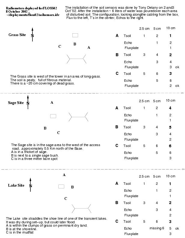
To view the configuration of the soil sensors at Grass, Sage and Lake:

Hit "Graphics Viewer", and then the little diamond.
- 116: Soil, Site all stns, Wed 22-Jan-2003 12:57:12 MST, TP01 wiring
- Previous - Next - Index
Graphic: 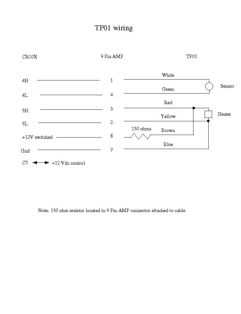
The graphics file shows the wiring ofr the TP01 probe. The color code
for the wires corrresponds to the probe wires and NOT the wires in the
logger box.
- 101: Soil, Site all stns, Tue 07-Jan-2003 13:40:58 MST, testing of thermal properties probes
At sage, 11:59 am, Jan 7, set the thermal properties cycle to 10 minutes
(from 180 minutes) so that Steve/Cody could check the voltages.

At 12:05, did the same at lake.

Steve determined at sage that the variation seen on Vheat is due to the
charging system.


At 1:30 pm, changed sage back to 180 minute cycle.  At 1:32, changed
lake back.

At 1:37pm, changed grass to 10 minutes.
At 3:51pm, changed grass back to 180 minutes.

The TP instructions are numbers 68 and 72

The values for normal 3 hour cycling are:
MODE 01:0000  68\r\n
68:P92  \r\n
01:0000  \r\n
02:0180  \r\n
03:30  \r\n
\r\n
MODE 01:0000  72\r\n
72:P92  \r\n
01:0003  \r\n
02:0180  10\r\n
03:30  \r\n
\r\n


For 10 minute cycling, change the second parameter from 180 to 10.
- 84: Soil, Site lake, Thu 19-Dec-2002 11:56:01 MST, Corrected therm prop. timing at lake
The logger at lake was looping through the thermal properties code every
3 minutes, instead of every 3 hours.  The code was changed to 3 hour
looping at 11:30am, Dec 19
- 80: Soil, Site all stns, Wed 18-Dec-2002 14:13:04 MST, Soil gravimetric/bulk density
The Sage, Lake and Grass C soil samples were not treated the same as were the A and B. Rather, the cores were extracted in toto and will be used for bulk density determination. Because of the limitation of the balance the cores were broken in two. The core portions were put into larger Al container, were weighed and then left to dry until the next visit. In all cases the ~20 cm of snow was removed and the ice crust atop the soil surface was broken and removed. At Grass dead grass stalks were also removed. Sage C Tare Fresh(18 Dec) Dry(1/7/03) 0 - 8cm ZI 8.0 143.2 122.0 ZII 8.0 149.0 115.2 Lake C Tare Fresh(18 Dec) Dry(1/7/03) 0 - 8 cm ZIII 8.0 120.5 87.0 ZIV 8.0 168.8 127.2 Grass C Tare Fresh(18 Dec) Dry(1/7/03) 0 - 8 cm ZV 8.0 76.2 top 4 cm peaty 34.3 ZVI 8.0 136.1 bottom 4 cm 106.4- 70: Soil, Site all stns, Tue 17-Dec-2002 16:21:07 MST, Gravimetric soil samples
Weighed the soil samples collected on Mon 16 Dec (see log entry 67) 11:40 Sage site. .At B, dug away 10 cm of snow. There was a 2 -3 cm ice crust on the soil surface. Very hard going to sink the core as the ground was frozen. Although the snow was completely removed from the surface before coring the ice incorporated in the soil melted in the base to yield mud. The corer stem broke and had to be replaced with a pice of pipe. Fresh Dry (18 Dec) 0-3 cm AI 25.3 17.6 AII 20.9 14.7 AIII 21.9 16.1 3-8 cm BI 26.1 21.6 BII 22.6 18.8 BIII 22.3 18.8 13:30 Lake site At B dug down through 30 cm of snow and brushed soil surface clear of snow Fresh Dry (18 Dec) 0-3 cm CI 13.3 11.5 CII 16.6 14.4 CIII 14.6 12.5 3-8 cm DI 13.9 11.3 DII 15.7 12.7 DIII 19.1 15.3 14:00 Grass site. At B 25 - 30 cm of snow. Dug down and then broke up crust incorporating dead grass stems and ice. Cleaned this away and started core at peaty surface. Fresh Dry (18 Dec) 0-3 cm EI 8.2 2.5 EII 7.4 2.4 EIII 6.7 2.4 3-8 cm FI 15.9 12.3 FII 17.3 12.7 FIII 19.7 15.3- 67: Soil, Site all stns, Mon 16-Dec-2002 17:55:08 MST, Gravimetric soil samples
Gravimetric soil samples are to be: top 3 cm next 5 cm The plan is to do Sage A, Lake A and Grass A on Mon, 16 Dec, dry overnight ......................B.......B B Tue 17.................. .......................C ......C.......... C....Wed..18 leave in oven Also to take total cores from three sites for bulk density and leave in oven 11:20 Sage site. Approx 10 cm of snow between bushes with almost no snow under some bushes.At A, under a bush with no snow cover, core sample. Fresh Dry (17 Dec) 0-3 cm AI 16.6 11.7 AII 12.4 8.5 AIII 13.1 8.8 3-8 cm BI 22.7 20.6 BII 23.7 21.6 BIII 24.2 21.9 12:00 Lake site Fairly uniform 20 -25 cm snow. Couldnt locate A so went approx the correct distance from box. Dug down through snow to soil and brushed the surface clear. Fresh Dry (17 Dec) 0-3 cm CI 15.6 11.0 CII 14.5 10.4 CIII 17.1 12.5 3-8 cm DI 23.4 21.5 DII 25.8 23.8 DIII 25.4 23.2 12:40 Grass site. Grass sticking out of 0-8 cm snow. Note that the top 1 cm was grass stalks. I discarded this and separated the dirtr component from the next 3 cm. The lower 5 cm was mostly dirt. Fresh Dry (17 Dec) 0-3 cm EI 5.5 2.9 EII 4.6 2.4 EIII 5.0 2.7 3-8 cm FI 9.5 6.8 FII 11.3 8.3 FIII 12.7 9.2- 61: Soil, Site lake, Mon 16-Dec-2002 17:40:33 MST, TP01 installed
TP01 SN 200235 installed at lake site ~1645.  It is installed about at 5cm in
the frozen sand.  It still has an air gap, though somewhat neater (and thus
smaller) than at the tower site -- I'm learning.
- 60: Soil, Site tower, Mon 16-Dec-2002 17:34:16 MST, TP01 installed
TP01 SN 200234 installed at tower site ~1345.  (It was connected an hour
earlier, but it was on top of the snow.)  It is installed about at 5cm in
the (peat-like) dirt.  I'm sure that there is an air-gap beside it, but
hopefully this will heal with time.
- 54: Soil, Site lake, Thu 12-Dec-2002 16:46:33 MST, Changed Tsoil sampling at sage,lake
Dec 12, 16:45 MST

As in logbook entry #51 at the grass site, changed the CR10x logger code
at lake and sage so that there is a 10 msec delay before sampling
the Tsoil probes.
- 51: Soil, Site tower, Wed 11-Dec-2002 10:27:54 MST, Modifed grass logger Tsoil sampling
Dec 11, 10:27 MST:

Added 10 millisecond delay to P11 instruction (#50) which is used to
sample T107 Tsoil probes. This is the 03 parameter, which we
changed from 1 to 21.

Lab testing showed that this reduces
noise, and so we hope this will reduce the noise on Tsoil that
we see when the radiometer fans are on.

This changed reduced the noise significantly, except on the 10cm
probes, which are sampled at another point in the CR10 code.


Dec 11, 15:13 MST

Changed the P11 instruction for the 10cm probes too (instruction 60).
Here is the  rserial output:

MODE 01:0000  60\r\n
60:P11  \r\n
01:01  \r\n
02:05  \r\n
03:01  \r\n
04:0027--\r\n
05:+1.0000 \r\n
06:+0.0000 \r\n
MODE 01:0000  60\r\n
60:P11  \r\n
01:01  \r\n
02:05  \r\n
03:01  21\r\n
04:0027--\r\n
05:+1.0000 \r\n
MODE 01:0000  60\r\n
60:P11  \r\n
01:01  \r\n
02:05  \r\n
03:21  \r\n
04:0027--\r\n
05:+1.0000 \r\n
06:+0.0000 \0x7f\r\n


Oops: looks like I didn't restart the logger with a "*0" and it didn't
resume until I rserial'd to it again at about 16:20.
- 46: Soil, Site tower, Mon 09-Dec-2002 09:09:34 MST, soil profile array cable installed
the soil profile array interface cable was installed on
Wed, Dec 4th
we are now receiving data
- 7: Soil, Site all stns, Mon 14-Oct-2002 10:02:32 MDT, FLOSS02 soil sensors
On Thurs, 10 Oct''02 Tony and John visited the FLOSS site The Echo soil sensors at Sage, Lake and Grass were reinstalled. They had been installed horizontally the previous week and had been watered to help them meld into the soil. This melding was apparently sucessful at Sage and Lake, where the soil was suitable, but not so sucessful at Grass, where the soil was actually peat. The Echo probes were reinstalled vertically, with their midlines at the designated depths of 5 cm and 10 cm. They were positions at right angles to each other with ~12cm between their cabled ends. Sage A 1 @ 5cm A 2 @ 10cm Sage B 3 @ 5cm B 4 @ 10cm Sage C 5 @ 5cm C 6 @ 10cm Each set of Echo probes waterd with 1 gallon Lake A 1 @ 5cm A 2 @ 10cm Lake B 3 @ 5cm B 4 @ 10cm Lake C 5 @ 5cm C 6 @ 10cm Each set of Echo probes watered with 1 gallon Grass A 1 @ 5cm (It is possible that A1 is actually at 10cm) A 2 @ 10cm (It is possible that A2 is actually at 5cm) Grass B 3 @ 5cm B 4 @ 10cm Grass C 5 @ 5cm C 6 @ 10cm Each set of Echo probes watered with 2 gallons- 4: Soil, Site lake, Fri 11-Oct-2002 14:51:44 MDT, Hft Probes 1,2 upside down
10/10/02

The sensors apparently didn't have the white dot and were installed
up-side down.  This is very apparent in the data.

Fix: can either be swap wires in logger, or change sign of logger coef.
- 3: Soil, Site all stns, Fri 11-Oct-2002 14:48:08 MDT, Soil Echo Probes Rotated to Vertical
10/10/02

Soil Echo Probes Rotated:
from Horizontal to Vertical orientation at Sage/Lake/Grass.
Water was dumped on to help bed the sensors in.  Tony said they already
were looking good in that respect.

The logger cable was added to the Lake site.  Both Sage/Lake are now reporting
data through goes.
- 1: Soil, Site all stns, Tue 08-Oct-2002 08:48:09 MDT, Installation of soil sensors
On 2 Oct''02 the locations for the soil sensors for Grass, Sage and Lake
 soil sensor arrays were chosen by Tony, Steve O and Jielun.
Tony installed the sensors at Grass and Sge on 2 Oct and installed the
sensors at Lake on the 3 Oct. After installation the sensors were wetted down
with approximately 6 liters of water to "bed them in". It is anticipated that
given another month of warm weather the local soil moisture will come to
equilibrium before the start of the program in December.
For the schematic of the placement see