Principal Investigator:
Dr. Philip J. W. Roberts
School of Civil and Environmental Engineering
Georgia Institute of Technology, Atlanta, GA 30332
Funding period: April 2006 - April 2009
Partners: Great Lakes Environmental Research Laboratory (GLERL)
Abstract:
One of the most serious, and complex, issues relating to human health around lakes and oceans is exposure to pathogens and other bacteria at beaches. High bacteria levels lead to beach closures, which are an increasing problem in the US, with significant economic consequences. They can be caused by local sources such as combined sewer overflow outfalls (CSOs) and contaminated rivers. This research focuses on the mechanisms that govern the fate and transport of bacterial contaminants in coastal waters, particularly their impacts on beaches. The goal is to develop reliable mathematical models of bacterial transport. This will enable prediction of potentially hazardous beach conditions, and particularly the improved design of related water infrastructure such as CSO systems and the water intakes that are needed to serve increasing populations.
The research is interdisciplinary with hydrodynamic and microbiological field measurements and development of mathematical models. It is part of the OHHI goal to develop early warning systems for health risks. We are focusing on river plumes that can carry significant bacterial contaminants due to surface runoff and, more seriously, combined sewer overflows (CSO.s). They can impinge on local beaches and can be entrained into water intakes. Plume dynamics are complex, involving physical, chemical, and biological processes that span a wide range of spatial and temporal scales from meters to kilometers, and seconds to hours and days.
Four comprehensive field experiments have been completed on the plume from the Grand River, which is subject to CSO.s from Grand Rapids, as it enters Lake Michigan at Grand Haven. The experiments involve simultaneous aerial photography, measurements of lake physical properties, and the addition of artificial tracers to track the plume. Four acoustic Doppler current profilers (ADCPs) were deployed, two of which also measure wind speed and direction and air temperature, and GPS-tracked surface drifters were released to measure surface water motions. In Summer 2007, we collaborated on simultaneous bacterial and pathogen measurements in the river and lake.
We find that critical conditions occur when the river is warmer than the lake. This occurs often in summer and causes the plume to form a thin surface layer about one to two meters thick that spreads dynamically. The plume behavior depends on lake currents and winds and is complex and highly variable; its mixing depends on the temperature differences, river flow, and lake turbulence.
We have developed mathematical models of these processes to predict plume behavior and therefore the transport of pathogens to local recreation areas. These include models of mixing and chemical and biological kinetics. Two three-dimensional hydrodynamic models are used in the far field: A coarse-grid model of the whole Lake Michigan, and a high resolution model around the source. In addition, a separate near-field model of the small-scale plume hydrodynamics is being developed that will incorporate the correct plume physics, such as buoyant surface spreading, into the gridded models. The mixing models are coupled together, with the output from the near field model becoming an input to the far field model. The model predictions are being compared to the field observations with good results.
Research Highlights:
Contaminated rivers that carry bacteria and pathogens can have major impacts on beaches. For example, Figure 1
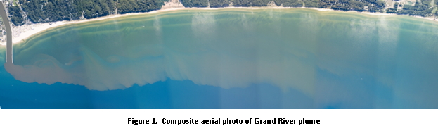
shows the plume from the Grand River traveling along the Lake Michigan coast and impinging on the shoreline. We have conducted extensive field experiments, shown schematically in Figure 2,
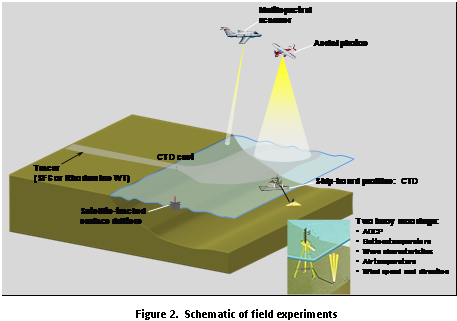
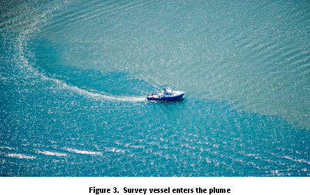
to understand the dynamics of these plumes. They include aerial photography, current measurements, lake profiling, tracer additions to the river, and bacterial sampling. Figure 3 shows the NOAA survey vessel entering the plume and Figure 4
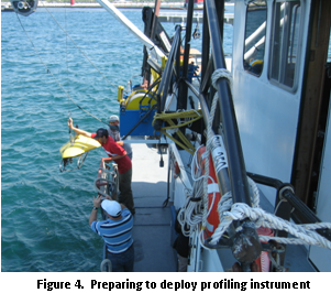
the deployment of the profiling "tow-yo" instrument package used to map the plume. This research has revealed the complexity and variability of the hydrodynamic processes that govern these plumes. They are dramatically influenced by very small temperature differences. For example, in the critical summer months the river is slightly warmer than the lake. This causes it to form a thin layer that "floats" on the water surface with a sharp boundary (clearly visible in Figure 1) that spreads with little mixing. The spreading can rapidly transport the plume and its associated contaminants to beaches.
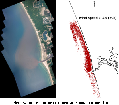
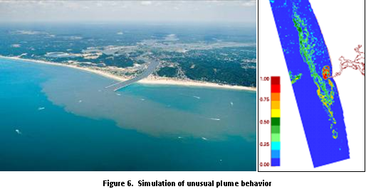
We have developed a high-resolution hydrodynamic model around the river mouth that is coupled to a whole lake model. We have developed particle-tracking models to simulate bacterial transport that have considerable advantages over the conventional gradient-diffusion approach. The models can accurately simulate plume transport under complex and varied conditions, as shown in the aerial photographs and model predictions in Figures 5 and 6.
Beach closures are rising rapidly in the US, with economic losses in the millions of dollars. The costs of water-related infrastructure to protect beaches and human health are even higher, in the billions of dollars per year. This is particularly true for many older cities that have combined sewer overflow schemes (CSOs), where untreated domestic sewage and stormwater runoff are combined and discharged into rivers and other waterways. Most CSO mitigation schemes are deep, large-diameter tunnels that can store some wastewater, provide some treatment such as chlorination, and release it at a controlled rate into the environment. These facilities have very high annual operating costs.
The results of this research have wide implications for the protection of human health, minimizing economic losses due to beach closures, and reducing the construction and operating costs of water infrastructure. The models can be used to provide early warnings of beach closures, which will enable beach managers to plan for them. They can be applied to the design and operation of infrastructure such as CSOs, CSO and domestic sewer outfalls, and water intakes, so that they maximize human health protection while minimizing cost. Coupling the models with real-time operation of CSO and wastewater treatment plants will enable .smart. operation of the plants, such as minimizing and optimizing chlorine addition. This reduces the considerable cost of chlorine, and also protects the environment, as chlorine can be a pollutant. The models can be used to find water intake locations that minimize the entrainment of bacteria (and sediment and other contaminants) thereby protecting drinking water supplies.
Products and Services:
- The major product/service from this project will be a reliable mathematical model that will be part of an early-warning system for bacterial beach contamination.
- The scientific contribution is improved understanding of complex dynamics of river plumes and their behavior under various forcing mechanisms.
- Methods to predict plume entrainment into water intakes.

Revised December 16, 2010
| Questions, Comments? Contact Us | Report
Error | Disclaimer | About
the Site | User Survey
Web Site Owner: National Ocean Service | National Oceanic and Atmospheric
Administration |
Department of Commerce | USA.gov
http://oceanservice.noaa.gov/education/welcome.html