A. Video
interview with V. Ramanathan of the Scripps Institution of
Oceanography.
|
B. Video
interview with Jeff Stith of the National Center for Atmospheric
Research.
 |
Click here or on image to view video.
Click here to enlarge photo.
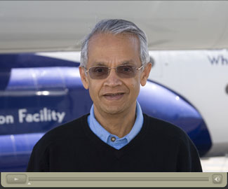
Ramanathan, a principal investigator on the Pacific Dust
Experiment (PACDEX), discusses how the massive plumes of dust and
pollantants from Asia may affect global warming. (Photo by Carlye
Calvin, Video by Jeff Alipit, ©UCAR.
News media terms of use*) |
Click here or on image to view video.
Click here to enlarge photo.
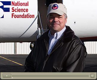
Stith, a principal investigator on the Pacific Dust Experiment
(PACDEX), discusses how the dust and pollutants can interact with
clouds. (Photo by Carlye Calvin, Video by Jeff Alipit, ©UCAR.
News media terms of
use*) |
C.
Satellite view of Asian dust near California
|
D. Satellite
view of Asian dust over the Pacific
|
Click here or on image to enlarge.
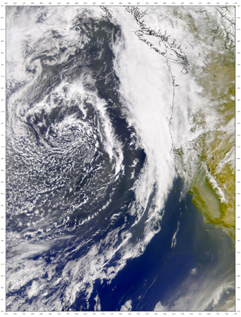
This April 15, 2001, NASA satellite image shows dust
arriving in California from Asian deserts. Concentrations of dust are
visible to the south, near the coastline (lower right of image); to
the west the dust is mixed with clouds over open ocean. This dust
event caused a persistent haze in places like Death Valley,
California, where skies are usually crystal clear. (Image courtesy
the SeaWiFS Project, NASA/Goddard Space Flight Center, and ORBIMAGE.) |
Click here or on image to enlarge.
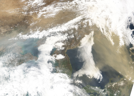
This NASA satellite image, taken on April 30, 2005, shows a plume
of dust flowing from China to the north of the Korean Peninsula and
over the Sea of Japan.The dust almost completely obscures the island
of Honshu from satellite view. Such plumes can cross the Pacific and
scatter dust across the Western United States.(NASA images created by
Jesse Allen, Earth Observatory, using data obtained from the Moderate
Resolution Imaging Spectroradiometer (MODIS) and Goddard Earth
Sciences. Image courtesy the SeaWiFS Project, NASA/Goddard Space
Flight Center, and ORBIMAGE.) |
E.
Readying the G-V research aircraft for PACDEX
|
F.
Behind-the-scenes, preparing for PACDEX
 |
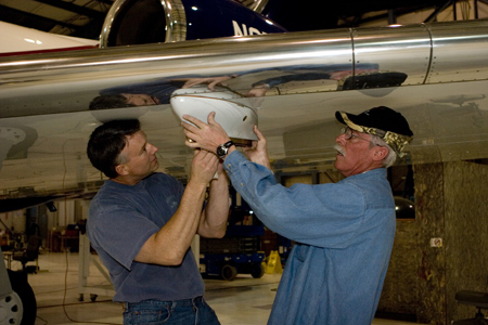
Click here or on image to enlarge.
NCAR engineer Kurt Zrubek (left) and aircraft mechanic Robert
Beasley attach part of a pylon mount on a wing of the NSF/NCAR
Gulfstream-V. The pylon will hold research instruments under the
airplane's wing. (Photo by Carlye Calvin, ©UCAR.
News media terms of use*) |
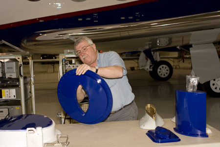
Click here or on image to enlarge.
James Nolan, an aircraft mechanic at NCAR, works on a mount that
will hold an instrument package on the fuselage of the NSF/NCAR
Gulfstream-V. The instruments will help scientists measure solar
radiation in the atmosphere. (Photo by Carlye Calvin, ©UCAR.
News media terms of use*) |
G.
Hypothetical PACDEX flight map
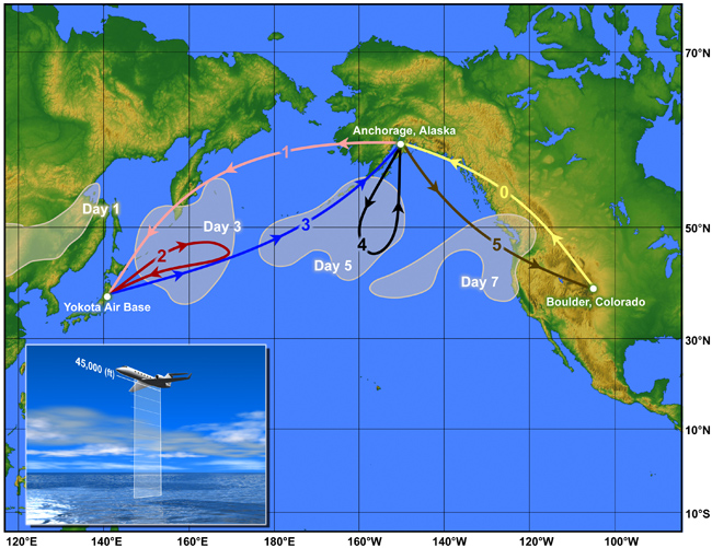 |
Click here or on image to enlarge.
This illustration shows a hypothetical plume and possible series
of flight patterns during the PACDEX field project. When a major
plume of dust and pollutants begins blowing off Asia, the G-V would
fly from Boulder to Anchorage, where it would refuel, and then fly on
to Yokota Air Base, Japan. It would then conduct a series of flights
for about a week in and around the plume as the plume moves over the
ocean to North America. (Illustration by Steve Deyo, ©UCAR.
News media terms of use*) |
G-2.
Flight path during the live chat with scientists
|
H.
Satellite measurements of Asian dust across the Pacific
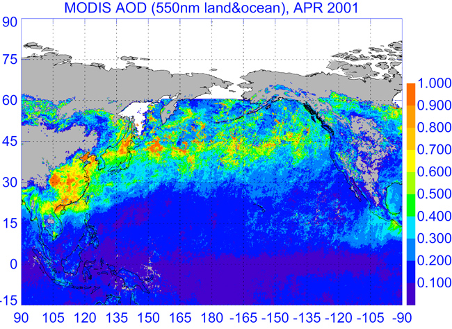 |
Click here or on image to enlarge.
This image, drawn from satellite observations, shows the movement
of a particularly large dust plume from Asia to North America in
2001. The purple and blue areas represent no or little dust in the
atmosphere; the yellow and orange areas represent a moderate to
high amounts of dust. The image uses a scientific measure known as
aerosol optical depth, which shows how much light in a column of the
atmosphere is blocked by airborne particles. The observations were
taken by the Moderate Resolution Imaging Spectroradiometer (MODIS),
flown aboard NASA's Terra satellite. (Image courtesy NASA.) |
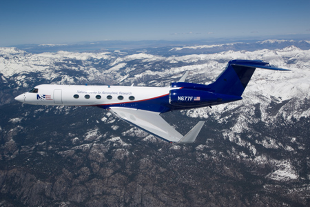
I.
The NSF/NCAR Gulfstream-V
 |
 |
Click here or on image to enlarge.
The NSF/NCAR Gulfstream-V in flight over the western United
States. (UCAR. News
media terms of use*) |
Click here or on image to enlarge.
Latest In-Flight Video Capture |
| Contacts for This Release |
| |
For Journalists
David Hosansky, head of Media Relations
303-497-8611, hosansky@ucar.edu
|
|
|
UCAR Communications
www.ucar.edu/news/contacts.shtml |
| |
General inquiries
Yvonne Mondragon, 303-497-8601, yvonnem@ucar.edu
Photo inquiries
Carlye Calvin, 303-497-8609, calvin@ucar.edu
Digital Image Library
www.ucar.edu/imagelibrary |
|
|
*News media reproduction to illustrate this story and nonprofit use permitted with proper attribution as provided above and acceptance of UCAR's terms of use. Find more images in the UCAR Digital Image Library.
The National Center for Atmospheric Research and UCAR Office of Programs are operated by UCAR under the sponsorship of the National Science Foundation and other agencies. Opinions, findings, conclusions, or recommendations expressed in this publication do not necessarily reflect the views of any of UCAR's sponsors. |


