
 SHEBA ISFF Flux-PAM Project Report
SHEBA ISFF Flux-PAM Project Report
SHEBA ISFF Flux-PAM Project Report
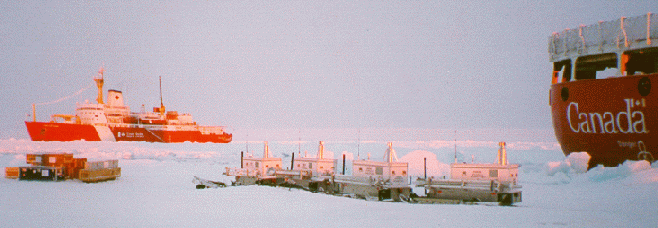
SHEBA (Surface Heat Budget of the Arctic) is an interdisciplinary program to study the interactions of clouds, atmospheric radiation, and the surface energy balance over the Arctic Ocean. The field phase involved the deployment of numerous measurement systems on board and in the vicinity of the Canadian ice breaker N.G.C.C. Des Groseilliers, which was frozen into the Arctic ice pack north of Alaska from October 1997 to October 1998. During this period, Ice Station SHEBA drifted from approximately 75° N, 144° W to 80° N, 166° W.
The research teams at the ice camp included the SHEBA Atmospheric Surface Flux Group (ASFG), which was responsible for direct measurement of the fluxes contributing to the surface energy balance. The principal investigators in this group are Ed Andreas (U.S. Army Cold Regions Research and Engineering Laboratory), Chris Fairall (NOAA Environmental Technology Laboratory), Peter Guest (Naval Postgraduate School), and Ola Persson (NOAA Environmental Technology Laboratory and the Cooperative Institute for Research in Environmental Sciences). The Atmospheric Surface Flux Group instrumented a 20 m micrometeorological tower located about 1 km from the Des Groseilliers and also requested the use of four NCAR Flux-PAM stations to measure fluxes over a variety of different surface types.
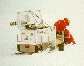
Flux-PAM remote meteorological stations are one of the principal components of the NCAR Integrated Surface Flux Facility (ISFF). These stations measure the standard meteorological variables of wind, temperature, humidity, pressure and precipitation plus net radiation, soil heat flux and the eddy fluxes of momentum, water vapor and sensible heat. To provide maximum siting flexibility, Flux-PAM stations are powered by solar-charged batteries and the sensor are mounted on an internally-guyed mast with a tripod base. The Flux-PAM data-processing computer, known as EVE, ingests data from the sensors at rates commensurate with their individual response characteristics and calculates 5-min means, variances and covariances. These data statistics are stored locally on EVE and also transmitted to a base computer system for archival, analysis and display. Data transmission is accomplished in real time either through the GOES satellite and/or, for networks of limited spatial extent, by means of line-of-sight RF modems. For SHEBA, RF modems were used to transmit the data from each station to a base computer located on the Des Groseilliers.
In order to meet the research requirements of the SHEBA Atmospheric Surface Flux Group, the Flux-PAM stations required several modifications.
|
| J. Militzer |
Several adaptations were also made to the standard complement of Flux-PAM sensors. Because of sensor maintenance requirements, no attempt was made to directly measure eddy fluxes of water vapor. The standard net radiometer was replaced by a 4-component measurement of incoming and outgoing, short and long-wave radiation utilizing aspirated Kipp and Zonen pyranometers and Eppley pyrgeometers. Since the standard platinum-resistance thermometer used by Flux-PAM has a lower limit of -40 °C, it was supplemented with a thermistor calibrated over the range -55 °C to 10 °C. Additional details are provided in separate sections that discuss each of the Flux-PAM sensors.
|
| J. Militzer |
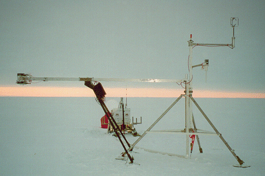
Fig. 2.1 SHEBA Flux-PAM Station
Figure 2.1 shows one of the SHEBA Flux-PAM stations (Atlanta?) in October 1997, shortly after setup. On the upper right is an R2 Solent sonic anemometer at a height of 3.5 m, and below the sonic is a hygrothermometer with the inlet of its mechanically-aspirated radiation shield at a nominal height of 2 m. The red strobe beacon can be seen at the top of the central mast and the electronic compass is in the cubical box mounted on top of the hygrothermometer boom. On the left is the 4-component radiometer array, also at a height of 2 m. Temperature and heat flux sensors have been installed below the radiometer boom at the snow-ice interface. In the background is the sled-mounted container housing the barometer, the thermoelectric generator, 12 V batteries, and the station data computer.
|
| P. Guest |
The Flux-PAM stations were installed and decommissioned by NCAR personnel.
However, with the exception of several visits by NCAR staff to the
ice camp, the stations were maintained by ASFG personnel.
Table 3.1 below is a record of Flux-PAM service personnel at the ice camp.
| Person | Dates | Person | Dates | |
|---|---|---|---|---|
| Kurt Knudson | 2 Oct-16 Oct 1997 | Ola Persson | 31 Mar - 23 April 1998 | |
| John Militzer | 2 Oct - 20 Oct 1997 | Peter Guest | 21 April - 14 May 1998 | |
| Ed Andreas | 2 Oct - 1 Nov 1997 | Ed Andreas | 12 May - 2 June 1998 | |
| Kerry Claffey | 2 Oct - 1 Nov 1997 | Dave Costa | 12 May - 1 July 1998 | |
| Steve Semmer | 16 Oct - 2 Nov 1997 | Dom. Ruffieux | 31 May - 1 July 1998 | |
| Gordon Maclean | 16 Oct - 2 Nov 1997 | Ola Persson | 2 July - 11 Aug 1998 | |
| Chris Fairall | 16 Oct - 25 Nov 1997 | Kerry Claffey | 3 July - 11 Aug 1998 | |
| Jeff Otten | 16 Oct 1997 - 14 May 1998 | Dave Costa | 11 Aug - 9 Sept 1998 | |
| Janet Intrieri | 26 Nov 1997 - 8 Jan 1998 | Peter Guest | 11 Aug - 9 Sept 1998 | |
| Steve Semmer | 7 Jan - 9 Jan 1998 | Scott Abbott | 9 Sept - 11 Oct 1998 | |
| Ann Keane | 7 Jan - 19 Feb 1998 | Ed Andreas | 9 Sept - 11 Oct 1998 | |
| Dan Wolfe | 17 Feb - 1 April 1998 | Tom Horst | 29 Sept - 11 Oct 1998 | |
| Tony Delany | 19 Feb - 11 Mar 1998 | John Militzer | 29 Sept - 11 Oct 1998 | |
| John Militzer | 31 Mar - 23 April 1998 |
Three of the Flux-PAM stations were deployed at distances of 1.5-2 miles from the ship, while Station 4 was deployed in the vicinity of the main ASFG tower for the purposes of data intercomparison and hardware testing. The ASFG Web site contains a useful collection of photos of the four Flux-PAM sites. The following site description are based on the cited logbook entries, as well as comments provided by Ed Andreas, Ola Persson, and other on-site personnel.
Atlanta was deployed on October 11, 1997, approximately 1.5 miles N of the ship on smooth, multiyear ice with a good potential for drifting snow. Ola Persson describes this station in April, 1998, to be on the southern end of a small floe, with a small lead 4 m to the S of the station which had a low ridge along its edge. This lead never opened substantially, and the low ridge was barely noticeable by June. The area to the SE through SW contained numerous ridges about 1-3 m high at various distances, but the fetch to the E was fairly smooth, with no ridges. In late April, a major lead opened roughly 60 m to the NE of the station.
On May 21, 1998, Ed Andreas recorded that Atlanta was approximately 1.6 km from the ship on a bearing of 84° true. The local ice thickness was approximately 1.9 m and the snow depth was 30 cm. The ice to the N and NE was noted to be rough, starting with the refrozen lead 100 m to the N. Ola notes that this lead was partly filled with ice floes over time, but it was still distinctly noticeable with open water even in June and July. On July 6, the distance from the edge of the lead to the Flux-PAM tripod was 91 paces (meters?). The ice blocks marking the edge of this lead were 1-2 m high, and substantial blocks were also floating as icebergs in the lead.
In July-August, Ola noted that some melt ponds were present at distances of 20-40 m in all directions. Although these melt ponds did not appear to contribute significantly to the radiometer measurements, the ice appeared darker (wetter) than at Baltimore.
On September 16, 1998, Ed noted that the location of Atlanta relative to the ship had changed little. The site was characterized by ridged ice, refrozen leads, and melt ponds to the N and NE, with smoother ice and melt ponds to the SE, S, and W. The local ice thickness had decreased to approximately 0.9 m and the snow depth was 6 cm. Atlanta was decommissioned on September 30, 1998. (See logbook entries 31, 495, 713, and 717.)
Table 4.1 lists snow depth observations by the SHEBA Snow/Ice Group, sampled at roughly 5 m intervals along a 200 m line near the site of the Atlanta Flux-PAM station. Snow depths in this and following tables have been summarized by Ola Persson from data provided by Don Perovich.
Table 4.1 Atlanta Snow Depth Observations
(cm, negative depths are melt ponds)
| Date | Average | Range | Date | Average | Range | |
|---|---|---|---|---|---|---|
| 97 10 16 | 14.4 | 6 to 31 | 98 06 10 | 21.9 | 1 to 60 | |
| 97 10 26 | 17.9 | 2 to 35 | 98 06 12 | 21.7 | 4 to 66 | |
| 97 11 18 | 23.6 | 3 to 46 | 98 06 14 | 20.3 | 3 to 58 | |
| 97 12 04 | 27.1 | 2 to 52 | 98 06 16 | 17.2 | 1 to 223 | |
| 97 12 23 | 23.4 | 3 to 59 | 98 06 18 | 11.6 | -7 to 55 | |
| 98 01 15 | 23.1 | 4 to 55 | 98 06 20 | 9.8 | -22 to 46 | |
| 98 02 02 | 31.4 | 6 to 67 | 98 06 22 | 3.8 | -23 to 32 | |
| 98 02 22 | 31.1 | 6 to 61 | 98 06 24 | 5.0 | -10 to 36 | |
| 98 03 09 | 31.4 | 5 to 60 | 98 06 26 | 8.0 | -12 to 35 | |
| 98 03 25 | 35.3 | 2 to 82 | 98 06 28 | 5.9 | -17 to 30 | |
| 98 04 04 | 37.2 | 4 to 94 | 98 06 30 | 6.3 | -20 to 31 | |
| 98 04 22 | 41.9 | -1 to 92 | 98 07 02 | 2.9 | -19 to 23 | |
| 98 05 01 | 42.4 | 4 to 88 | 98 07 10 | 1.1 | -27 to 16 | |
| 98 05 16 | 44.6 | 2 to 97 | 98 07 14 | -0.4 | -32 to 14 | |
| 98 05 27 | 41.0 | 3 to 84 | 98 07 20 | -6.5 | -40 to 9 | |
| 98 06 03 | 30.1 | 0 to 109 | 98 07 24 | -7.3 | -44 to 8 | |
| 98 06 06 | 22.2 | 4 to 68 | 98 09 02 | 4.2 | 0 to 13 | |
| 98 06 08 | 20.6 | 2 to 60 | 98 09 14 | 6.4 | 1 to 13 |
Cleveland was deployed on October 12, on rough ice approximately 2 miles S of the ship. The local snow depth was 5 cm. Ed Andreas notes that "no one has probably ever intentionally placed meteorological equipment on such rough ice. This is a rubble field with broken ice in all directions." On February 6, 1998, Station 2 was trapped in an overriding ridge of ice, seriously mangled, and temporarily decommissioned. (See logbook entry 37.) Table 4.2 lists snow depths measured by the SHEBA Snow/Ice Group, along a 200 m line near the site of the Cleveland Flux-PAM station.
Table 4.2 Cleveland Snow Depth Observations
(cm, negative depths are melt ponds)
| Date | Average | Range | Date | Average | Range | |
|---|---|---|---|---|---|---|
| 97 10 22 | 18.1 | 6 to 47 | 97 12 13 | 21.6 | 5 to 46 | |
| 97 11 07 | 17.4 | 5 to 46 | 98 01 05 | 20.9 | 4 to 45 | |
| 97 11 19 | 21.7 | 6 to 55 | 98 01 17 | 17.4 | 2.5 to 43 |
On April 3, Station 2 was resurrected adjacent to Florida, and over the next two weeks it was used for various tests, including a radiometer intercomparison. Then on April 16, Station 2 was moved to a new site, named Seattle and described by Ola Persson to be on a flat, refrozen-melt pond area of 50-60 m radius. Beyond this range, a major ice block rubble field extended from E to N to SSW, with an especially heavy concentration and long fetch (kilometers) of rubble towards the NE. Even the SSE direction had some ice block rubble. The ice blocks towards the S (towards the ship) were less extensive, but still present. Ed Andreas described the site "as if in a fortress since it is rimmed 100-200 m away in all directions with ridges." It was considered a dangerous site because of the cover provided for polar bears. The ASFG tower was at about 150° and about 600-700 m distant. The Snow/Ice Group had a thermistor string about 30 m away, and nearby snow-depth monitoring as well. The snow depth data are tabulated with the description of the Florida Flux-PAM site.
On May 16, the Seattle site was about 0.9 km from the ship on a bearing of 356° true and was characterized by rough, multiyear ice. There was an active lead 400 m to the N and many local cracks, centimeters to meters wide, exposing open water. The local ice thickness was approximately 1.9 m and the snow depth was 19 cm. In June, a NW-SE lead opened 10-20 m to the SW of the Flux-PAM station, cutting off access to the site and fueling fears of damage if the lead closed. (See logbook entries 258, 400, 495, and 517.)
On June 10, Station 2 was moved once more after the Seattle site deteriorated to a peninsula. The new site, named Maui, was on rough ice located about 3/4 mile NW of Atlanta and 1090 m from the ship on a bearing of 47°. There was a big lead about 50 m radius going from the N to the E of the site, and a pressure ridge 2.5 m high that followed a lead about 30 m from the site. The tripod was on a small hummock/old pressure ridge and there was also a 2m-high icy peak about 10 m W of the site. Dominique Ruffieux thought the site to be quite interesting even if the surroundings were not very rough. He noted a lead located about 100 m to the NE of Maui and a ridge at about 50m to the N and NE of the site. Dominque described the surface to be "quite hilly with some pointing at 1 m agl and others at 1-2 m agl." Dave Costa noted "a nice big lead about 200 yards NNW and a pressure ridge about 100 yards E of the site."
Ola Persson described the site on July 6 to be located on gently-hilly multi-year ice, with shallow melt ponds beginning to fill the "valleys". A significant ridge was located 100 m to the E of the site, and a smaller ridge was located several hundred meters to the W (towards the ship). On this visit, the snow was hard and crusty. Ola noted that the melt ponds grew rapidly during the summer, surrounding the site with water. The sled and the tripod were on separate ice islands or peninsulas. By early August, ice movement and melting had produced some holes of open ocean water just on the north side of the sled pedestal. Throughout, the radiometers had been over their own ice peninsula/island. On August 7, the radiometer boom was moved slightly to hang directly over a melt pond in order to observe more directly the changes in the melt ponds during freeze-up.
By September 2, Maui was a small island of ice in a very active region. During the morning the radiometers were over an area of brash ice. The immediate area (within 30 m) around Maui was about 50% open water. This dropped off to less than 5%, except in a region running approximately NW to SW which was active and about 30% open water. There was more ridging right under the sonic mast and around the edges to the left and right of the sonics. Rafting ice depressed the sonic side of the floe but ridging under the outer leg kept the tripod level. Then by the afternoon, the floe had rotated about 90° and there was much more open water in the immediate region, with the radiometers positioned over open water.
On September 16, Maui was roughly 1.1 km from the ship on a bearing of 56° true. The Flux-PAM station was on a small floe with broken ice all around and open and refrozen leads and dark melt ponds nearby. The radiometers were positioned over new ice. The local ice thickness was approximately 0.3 m and the snow depth was 5 cm. By September 20, the Maui ice floe had rotated 90° clockwise and a ridge had appeared under the radiometers. Since the sled and radiometer stand were sitting in sea water pooled on the ice, and the main tripod and mast were on a separate floe, the station was dismantled and returned to the ship. (See logbook entries 520, 666, 699, and 713.)
Baltimore was deployed on October 12, 1997, approximately 2 miles E of the ship on smooth first-year ice surrounded by older, hummocky ice. It was roughly at the south end of a north-south refrozen polyana about 400 m long and 150 m wide. The local ice thickness was about 0.4 m and the snow depth was 2 cm. The Snow/Ice Group reports that a "substantial ridge" formed in January at the "edge of their snow line", which ran for 200 m NNW-SSE over the frozen polyana about 125 m to the NE of the Flux-PAM station. There are verbal reports of a 300-500 m wide lead in January 1998 about 2.5-3 km to the WNW of this site.
On May 15, Ed Andreas reported this station to be roughly 4.5 km from the ship on a bearing of 166°. The surrounding ice was fairly smooth with the exception of a refrozen lead and rougher ice to the SE. The local ice thickness was approximately 1.4 m and the snow depth was 50 cm. Ola Persson noted that the edge of the polyana on which Baltimore was located was marked by ice blocks, which were about 60 m from the site to the N, 150-200 m from the site to the E and S, and even further to the WSW. A particularly high "escarpment", used as a landmark to locate the site, was located about 100 m to the NNE of the mast. The tripod was buried in snow almost up to its crossbar. Table 4.3 lists observations by the SHEBA Snow/Ice Group sampled at roughly 5 m intervals along a nearby 200 m snow line. The average snow depth in April was 37-43 cm, which appears to be the maximum for the year (see Table 4.3).
Table 4.3 Baltimore Snow Depth Observations
(cm, negative depths are melt ponds)
| Date | Average | Range | Date | Average | Range | |
|---|---|---|---|---|---|---|
| 97 10 15 | 15.8 | 6 to 36 | 98 03 30 | 27.2 | 7 to 62 | |
| 97 10 26 | 17.5 | 2 to 52 | 98 04 14 | 42.8 | 3 to 83 | |
| 97 11 11 | 22.8 | 3 to 81 | 98 04 28 | 37.3 | 1 to 119 | |
| 97 12 10 | 25.9 | 4 to 90 | 98 05 13 | 35.2 | 5 to 115 | |
| 98 01 01 | 23.9 | 2 to 100 | 98 05 28 | 33.4 | 2 to 116 | |
| 98 01 13 | 25.6 | 3 to 86 | 98 06 04 | 21.0 | 1 to 98 | |
| 98 03 04 | 28.9 | 7 to 65 | 98 06 18 | 6.6 | 0 to 72 | |
| 98 03 18 | 19.9 | 0 to 42 | 98 06 29 | -1.0 | -42 to 34 | |
| 98 07 09 | -4.9 | -75 to 20 |
Ola Persson noted that in July there were extensive melt ponds in all directions from the site, with the exception of an area within 50-80 m of site. He observed 3 cm of crusty snow around the tripod on July 9 and a dusting of snow and thin ice on the melt ponds on July 30. By early August the melt ponds were closer, but the immediate area around the tripod was still free of melt ponds.
On September 20, Ed Andreas observed that Baltimore was roughly 10 km from the ship on a bearing of 115°. It was surrounded by ridged ice and refrozen leads, producing a very broken surface all around. The local ice thickness was approximately 0.3 m and the snow depth was 9 cm. Baltimore was dismantled the next day because of the thin, highly-active ice in the vicinity. (See logbook entries 33, 495, 703, and 713.)
Florida became operational on October 22 and remained in the vicinity of the main ice camp throughout the project. At its initial location, the ship and main camp were 100-400 m to the SW. The local surface was smooth, multi-year ice with a snow depth of 10 cm. On April 1, Florida was moved to 40 m NW of the ASFG hut at about 280° from the ASFG tower. The new site was about 35 m W of the ASFG radiometers. From April 3-15, Station 2 was also set up nearby, prior to moving it to the Seattle site.
Florida was moved again on April 20 to a site on top of a hummock or ridge, about 250 m NW of the ASFG tower and roughly 200 m N of the previous location near the ASFG hut. Ola Persson noted that the thickness of the ice ridge was 8 m, and that it was aligned with a direction of 65°-75°. From this site, the floe was flat and open to the E and SE, while to the N and W there were some ice blocks. The "camp ridge" ran N-S about 200 m W of the site. The Snow/Ice Group had a thermistor string on the ridge about 75 m W of the site.
On May 16 Ed Andreas observed that Florida was roughly 0.5 km from the ship on a bearing of 9° true. There was a major ridge 200 m W of the site, a refrozen lead and ridging 200 m N, and very smooth ice to the E. In general there were few obstacles within 200 m of the station. The local ice thickness was approximately 3 m and the snow depth was 32 cm.
Ola Persson noted that in July and August the terrain nearest the Florida site was very hilly, crusty ice and snow, and was about 1-2 m higher than the rest of the floe. Consequently, there were no major melt ponds in its immediate vicinity. However, numerous sizeable melt ponds were located 50-100 m towards the SE through SW (towards the ASFG tower and camp). On August 4, the floe to the NW of Florida sheared off (taking the Snow/Ice Group's Quebec site with it), so that a large expanse of open water was then present 100-150 m to the W through N from the Florida site.
On September 20, Florida was 0.47 km from the ship on a bearing of 12°. There were melt ponds, leads, and broken ice to the N and W, other hummocks to the E, and the ship and main camp to the S. The local ice thickness was approximately 4 m and the snow depth was 6 cm. Florida was decommissioned on September 30, 1998. (See logbook entries 66, 348, 411, 495 713, and 718.)
Table 4.4 lists observations by the SHEBA Snow/Ice Group along a 500 m (150 m after August 3) line running from the vicinity of the Florida ridge site to the Seattle site.
Table 4.4 Mainline Snow Depth Observations
(cm, negative depths are melt ponds)
| Date | Average | Range | Date | Average | Range | |
|---|---|---|---|---|---|---|
| 97 10 11 | 11.6 | 6 to 35 | 98 05 26 | 34.7 | 1 to 117 | |
| 97 10 17 | 12.2 | 6 to 38 | 98 06 01 | 27.0 | 1 to 100 | |
| 97 10 19 | 13.2 | 5 to 68 | 98 06 04 | 19.0 | 0 to 103 | |
| 97 10 21 | 16.3 | 5 to 74 | 98 06 06 | 21.3 | 1 to 91 | |
| 97 10 26 | 15.4 | 5 to 69 | 98 06 08 | 19.0 | 1 to 92 | |
| 97 10 29 | 14.2 | 1 to 62 | 98 06 10 | 19.9 | 1 to 90 | |
| 97 11 03 | 15.3 | 1 to 57 | 98 06 12 | 19.4 | 0 to 91 | |
| 97 11 10 | 16.2 | 3 to 77.5 | 98 06 14 | 16.8 | 1 to 96 | |
| 97 11 16 | 21.6 | 3 to 77 | 98 06 16 | 15.5 | 1 to 85 | |
| 97 11 22 | 24.4 | 6 to 78 | 98 06 18 | 10.9 | -1 to 78 | |
| 97 11 29 | 27.7 | 4 to 93 | 98 06 20 | 13.7 | -1 to 74 | |
| 97 12 09 | 23.8 | 4 to 75 | 98 06 22 | 12.8 | -21 to 129 | |
| 97 12 16 | 25.5 | 5 to 95 | 98 06 24 | 4.5 | -29 to 63 | |
| 97 12 23 | 26.6 | 4 to 84 | 98 06 26 | 6.4 | -52 to 62 | |
| 97 12 30 | 24.1 | 4 to 72 | 98 06 28 | 5.1 | -31 to 53 | |
| 98 01 09 | 22.4 | 2 to 95 | 98 06 30 | 3.7 | -39 to 53 | |
| 98 01 18 | 18.5 | 3 to 65 | 98 07 02 | 1.3 | -36 to 43 | |
| 98 02 14 | 20.5 | 0 to 100 | 98 07 04 | 1.5 | -33 to 40 | |
| 98 02 23 | 19.0 | 1 to 88 | 98 07 10 | 2.6 | -28 to 26 | |
| 98 03 03 | 26.8 | 4 to 97 | 98 07 14 | -0.4 | -73 to 26 | |
| 98 03 10 | 29.3 | 2 to 80 | 98 07 22 | -2.9 | -40 to 7 | |
| 98 03 17 | 25.2 | 2 to 107 | 98 07 26 | -3.0 | -38 to 10 | |
| 98 03 26 | 24.8 | 2 to 67 | 98 07 30 | -1.2 | -57 to 11 | |
| 98 04 03 | 29.6 | 1 to 111 | 98 08 03 | -1.4 | -42 to 11 | |
| 98 04 11 | 31.5 | 2 to 113.5 | 98 08 09 | -4.2 | -44 to 9 | |
| 98 04 19 | 34.4 | -2 to 118 | 98 09 07 | 8.7 | 0 to 28 | |
| 98 04 25 | 33.5 | 3 to 124 | 98 09 14 | 8.3 | 0 to 25 | |
| 98 05 02 | 35.4 | 1 to 121 | 98 09 22 | 10.8 | 1 to 36 | |
| 98 05 12 | 40.0 | 2 to 120 | 98 10 07 | 14.7 | 3 to 42 | |
| 98 05 18 | 34.8 | 2 to 117 |
| Table of Contents | Top | Next |