Flight ID:
- 940524I
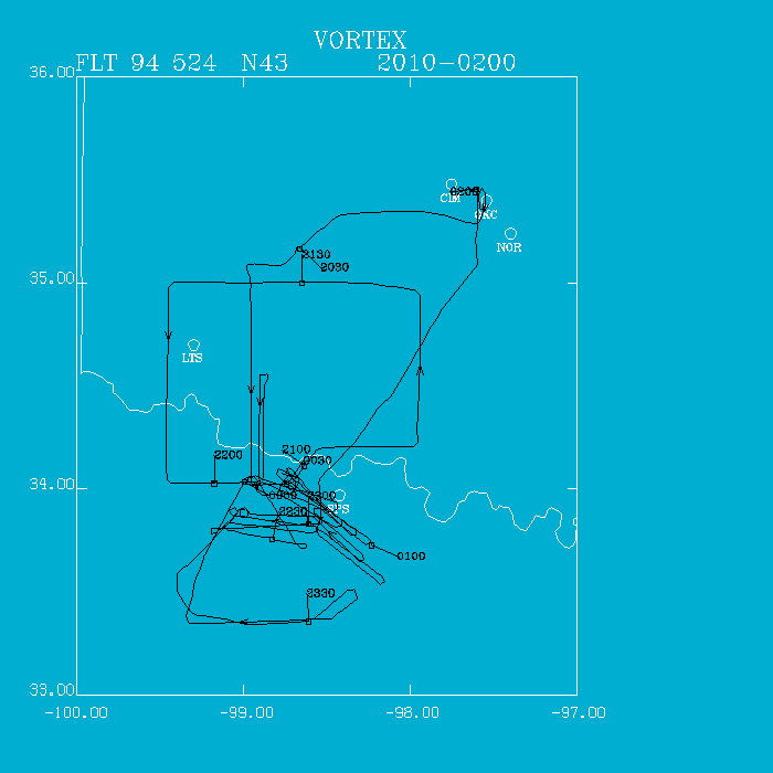
Flight Track:
Click image for full resolution.
Chief Scientist: Watson/Ziegler         Flight Director:  Damiano
Doppler Radar:   Shepherd/Atkins        Pilots:           Tichnor/Tennesen
                                                          Kennedy
Cloud Physics:   Jacobs                 Data Technician:  Pradas
Observer:                               Systems Engineer: Lynch
Media:           Irish Air Letters (2)


Takeoff Time: 2010 UTC                  Landing Time: 0206 UTC
Official Mission Duration: 6.2 hrs
Number of Data Tapes Used:  Radar: 2    Cloud Physics: 1        Video: 2

Data Systems Log

Radar Data System Log   Time On(UTC)    Time Off(UTC)   Comments
                        2030                            Begin REC on LF/TA
                                        2010            Stop REC on TA
                                        2116            Radar down
                                                        Rewinding Tapes to
                                                       start again
Tape #1                 2223                            Begin REC LF/TA
                                        2308            Radars down
Tape #2                 2326                            Begin REC again
                                        0044            Radars down
Tape #3                 0050                            Radars up
                                        0202            Stop REC LF/TA

Cloud Physics Log       Time On(UTC)    Time Off(UTC)   Comments
                        2023            0143            Recycled after
                                                        check
We broke off the pattern to evaluate an east-west convective line developing in the vicinity of Archer and Seymour, TX some 30 mi SW of Wichita Falls.. The ground teams were enroute. We made several east-west convective patterns on the north side of the convection. While the radar rebooted, we crossed through the weak line to the south side and made several Doppler pattterns. However, the convection remained weak and the ground teams became impatient and departed for a cell just northwest of Wichita Falls (SPS) which had apparently developed in the low-level cyclonic circulation which we sampled 2 hours before.
NOAA 43 arrived at the supercell at 0000 UTC and immediately setup east-west Doppler patterns. Visually, the wall cloud could be seen for the first 15 min. Storm motion was toward the southeast at 25 kts. We continued sampling the storm until 0131 UTC making some 12 to 14 passes on the cell.
Apparently, at 0045 UTC when the radar went down, the radar tapes were accidently rewound. At 0051 UTC, when we started our southest-bound leg we started copying over the old data. We were assured on our first flight that this was not the case. Therefore, from this point on, we will always put in a new tape when the radar is rebooted. It ramains to be seen if the data are recoverable after the 2 EOFs at 0150 UTC when we ceased collecting data. The mission was successful and proved that we can identify the mesocyclone region of the supercell and fly tight short legs sampling the convective evolution of a supercell. Baseball size hail was reported near Granfield, TX. Very strong outflow was observed on the ground from the P-3 and a very well developed shelf cloud formed on the southern flank. The supercell appeared to feed on the west side and had a somewhat tilted appearance in the later stages. NOAA 43 arrived back in OKC at 0206 UTC accumulating 6.2 hours flight time. The repeater seemed to act somewhat erratic today with periodic clicking sounds.
Irv Watson