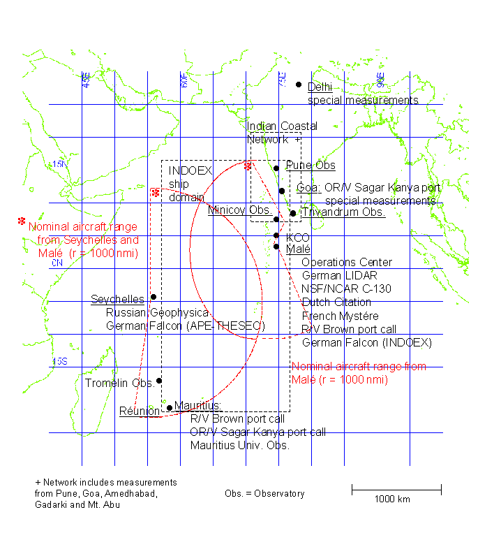
Figure 3 shows the project area
for INDOEX. Major data collection locations (fixed and mobile) are on this
figure or described in the caption. Both operational and research data
to be collected are described in this section. Research data will come
from the aircraft and ship platforms as well as land-based locations. Appendix
A provides specific information for most of the research data sets.
Operational data will include satellite, sounding, surface, and model output
(including trajectories) data sets to be collected for INDOEX. Appendix
B provides a specific listing of these anticipated data from operational
and model sources for the region. These lists will continue to be updated
and modified as data samples and final data sets are received by the Data
Archive Centers.
As noted in Section 3.3.1, INDOEX will implement an on-line catalog for the field phase. If the participants are conscientious about keeping the on-line catalog current, it can be a valuable tool to help the investigators assess progress toward achieving scientific objectives and in operations decision making. An electronic form which can be completed using the WWW will also be available. Following the IFP, all the on-line catalog information will be transferred into the CODIAC system which will become the access point for INDOEX PIs and the broader scientific community that will analyze this data set.
To achieve full utility in the field, certain critical data are needed. The following daily reports are expected from field participants:
Sounding reports from operational and research sites - Sounding
reports will be primarily monitored from the GTS transmissions. In addition,
reports (and in some cases actual data) will be received from the R/V
Ron Brown, Kaashidhoo Climate Observatory (KCO), Diego Garcia U.S.
Navy Base, and selected Indian coastal sites. All status reports (and data)
will be entered into the on-line field catalog as they become available.
Ship reports - A formatted status message will be prepared and
sent from the R/V Ron Brown on a daily basis. It will contain pertinent
information on critical equipment and operations status as well as a daily
ship operations summary. It will be transmitted to the INDOEX Operations
Center (Hulule) via satellite e-mail and entered into the on-line field
catalog as soon as possible. Periodic status reports for the ORV Sagar
Kanya will be transmitted to the INDOEX Operations Center via satellite
telephone or facsimile either directly from the ship or from the Indian
National Institute of Oceanography (NIO). It may also be possible to obtain
status for other ships of opportunity (WOCE cruises, etc.). They will be
included in the on-line field catalog whenever possible.
Aircraft reports - A daily (or following each flight on multiple
mission days) summary status report will be provided from all INDOEX aircraft.
They will contain pertinent information on critical equipment and operations
status as well as a daily aircraft operations or mission summaries. These
summaries will be entered into the on-line field catalog to be used for
planning and data analysis purposes.
Other Operational Data - JOSS will maintain status on a variety
of supplementary operational data sets (whenever available) including geostationary
and polar orbiter satellite imagery, surface observations, model products/trajectories
and preliminary operational data. Status updates and daily operations summaries
will be available in the on-line field catalog as they become available,
normally on a daily basis.
Other Research Data - All PIs both in the field as well as those
producing products away from the Operations Center are requested to submit
these data/model output products to the on-line field catalog on a periodic
basis. These data sets are considered "preliminary" and will be used primarily
for in-field analyses. They will not be available on the JOSS mirrored
catalog in Boulder, Colorado. Further, these data sets/products may be
imported to the in-field C4 CIDS Data analysis system running at the INDOEX
Operations Center.
JOSS plans to have some software tools available in the INDOEX Operations Center to permit perusal of field data. Also, CIDS, a SIO/C4 developed display and analysis system allowing the user to overlay and compare a variety of data sets (satellite, soundings, surface data, aircraft tracks and research data, etc.) in a workstation environment, will be available for use by the on-site PIs. It is also desirable to have other tools such as some simple graphics (X-Y plots, time-series, etc.) for intercomparison of specific constituent measurements. The PIs will be consulted on preferred tools for this purpose (spreadsheets, IDL, etc). JOSS will provide limited support to include specific data display requirements with the on-line field catalog.
The need for data from other programs operating spatially or temporally close to INDOEX are very important to INDOEX. Efforts will be made to coordinate closely with the APE-THESEO Project operating from the Seychelle Islands during the INDOEX IFP. Data will be requested from these facilities through formal channels. It is also expected that supplementary measurements will be made at selected sites specifically for INDOEX. Data from these and other programs will be requested and included in the INDOEX archive as available.