| |
Click on the maps for larger image |
| |
|
| Regional Surface Meteorological Networks |
| |
|
| WJAR WeatherNet
- WJAR-TV in Providence, Rhode Island operates this network of 53 stations located
primarily at schools throughout Rhode Island, Massachusetts and 1 in New York (37 in Massachusetts). The
network provides up to 1-minute observations of air temperature, relative
humidity, wind speed, wind direction, precipitation, and barometric pressure.
For further information visit the
WJAR network page. |
No map yet. |
| |
|
| State and Local Surface Meteorological Networks |
| |
|
| None. |
|
| |
|
| Precipitation and Radar Networks |
| |
|
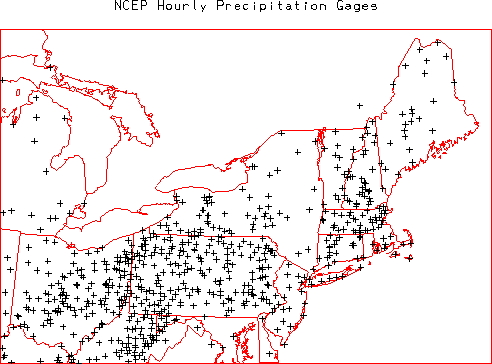
| NOAA/National Centers for Environmental
Prediction (NCEP) Hourly Precipitation Data - NOAA/NCEP routinely develops
a National Multi-sensor Hourly Precipitation Analysis (Stage II) data set from
hourly radar precipitation estimates and from hourly gage reports. The gage data
includes hourly observations from ~4000 gages across the US (3 in Rhode Island)
collected by the NOAA River Forecast Centers and sent to NCEP. Further information
on these data is available at:
http://wwwt.emc.ncep.noaa.gov/mmb/ylin/pcpanl/. |
 |
| |
|
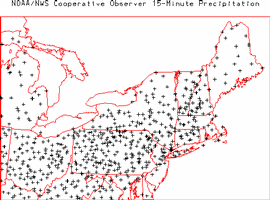
| NOAA/NWS Cooperative Observer 15-minute Precipitation Network - The NOAA/NWS
routinely collects 15-minute observations of precipitation from Fisher-Porter and Universal
rain gages operated by 2777 cooperative observers located throughout the US (2 in Rhode Island).
These data are archived at NOAA/NCDC as data set TD 3260. For further information visit the
NOAA/NCDC TD3260 page. |
 |
| |
|
| Radiation and Flux Networks |
| |
|
| None at present |
|
| |
|
| Soil Networks |
| |
|
| None at present. |
|
| |
|
| Hydrology Networks |
| |
|
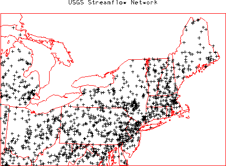
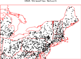
| United States Geological Survey (USGS) Streamflow
Network - The USGS (part of the US Department of the Interior) operates this
network of 7237 streamflow gages (8 in Rhode Island) at locations throughout the US.
The network provides hourly or more frequent observations of stage (water level) from
which discharge (flow) is comuputed using a stage-discharge rating relation. The
rating is defined by occasional direct current-meter measurements of discharge. All
data are available through the USGS and the district offices in each state. Many of
these gages provide realtime data
relayed via the GOES satellite data collection system. The realtime data are
provisional data that have not been reviewed or edited. These realtime data
may be subject to significant change and are not citeable until reviewed and approved
by the USGS. Realtime data may be changed after review because the stage-discharge
relationship may have been affected by: 1) backwater from ice or debris; 2) algal and
aquatic growth in the stream; 3) sediment movement; and 4) malfunction of recording
equipment. Each station record is considered provisional until the data are
published. The data are usually published with 6 months of the end of the water year
(1 October to 30 September). Data users are cautioned to consider carefully the
provisional nature of the information before using it. For further information on the
USGS stremflow network visit the
USGS Water Resources of the United
States page or the
USGS Rhode Island District Office
home page. |
 |
| |
|
| Upper Air Networks |
| |
|
| None at present |
|
| Aerosol Networks |
| |
|
| None at present |
|
| Coastal Networks |
| |
|
| |
|
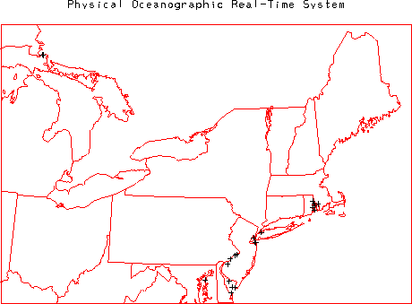
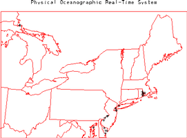
| Physical Oceanographic Real-Time System (PORTS)
- The National Ocean Service (NOS) operates this network of 51 weather stations with
locations within bays and harbors along the Atlantic and Gulf of Mexico coastlines
(5 in Rhode Island). The network provides 15-minute observations of air temperature,
wind speed, wind direction, barometric pressure, water temperature, and water level.
For further information visit the
PORTS home page
. |
 |