(DRAFT)
Cumulus Photogrammetric, In-situ and Doppler Observations (CuPIDO)
Scientific Overview Document
Joe Zehnder, Arizona State University
Bart Geerts and Rick Damiani, University of Wyoming
1.1 Objectives and scientific hypotheses
1.2 Relation to previous field studies
1.3 Photogrammetric techniques for studying cumulus development
1.4 Airborne cloud
radar studies of cumulus dynamics
4.2 Surface and upper air observations
4.4 Forecast support and data management
Cumulus convection is of fundamental importance to the development atmospheric circulations from the meso-g scale to the planetary scale as is serves as one of the primary mechanisms for the vertical transfer of heat, moisture and momentum. Details of the evolution of cumulus convection and particularly the transition from shallow to deep convection are important, since these processes must be parameterized in numerical weather prediction and general circulation models. Observation of cumulus convection is difficult owing to the short time scales and high degree of spatial variability associated with the phenomenon. The “sky islands” of the desert southwest serve as a natural laboratory for cumulus convection, owing to the development in a fixed location at rather regular times every day, under the influence of localized latent and sensible heat flux and upslope flow. Moreover, orographic convection carries its own intrinsic interest: how does the dry anabatic flow within the boundary-layer transform into tropospheric circulation driven by deep convection? How much energy and momentum does convection over isolated mountains transfer vertically?
The prime objective of CuPIDO is to characterize the onset
and transition from shallow to deep convection over a desert southwest sky
island, using surface and upper air measurements, various ground-based
profiling systems, in-situ and Doppler aircraft observations and stereo digital
photogrammetric techniques.
The central hypothesis of CuPIDO is that deep convection and precipitation development only occur once the column over the terrain is sufficiently moistened by shallow convection to prevent erosion of convective turrets by entraining dry environmental air. This hypothesis requires detailed monitoring of changes in the potential temperature and mixing ratio in the boundary-layer inflow, as well as in the mid-troposphere. While high values of moist static energy are detrained above the convective boundary-layer (CBL), lower values may be detrained into the CBL by convective downdrafts, contributing the pulsating nature of the towering convection phase. The duration of this phase varies daily, presumably depending on the profiles of wind and thermodynamic properties.
This hypothesis is specific to sky islands but its fundament
has broad applicability to both shallow and deep cumulus convection in
conditions of near-moist-neutral stability and weak shear, as prevail over the
tropical warm ocean regions, and it may be a key factor in the explanation of
the observed longevity of clusters of convective turrets in these regions.
The CuPIDO field experiment, conducted in July-August 2006
over the Catalina Mountains in Arizona, will employ an array of ground based
and airborne observing platforms. The following instruments are supported
at this time: pairs of digital cameras that will be located near the base
of the mountains, a network of ten PAM-III stations, four of which will be
equipped with towers to measure surface latent and sensible heat and turbulent
momentum transfer, two mobile
GPS based sounding systems (MGAUS) and
the University of Wyoming King Air (UWKA) with the 95GHz (W-band) multi-antenna
Wyoming Cloud Radar (WCR). The WCR is capable of 30 meter resolution and hence
will reveal details of the entrainment processes. Other probes may be in the
field as well, pending the success of several proposals. These include a network
of GPS receivers (integrated water vapor) and various profiling remote sensors.
1. Introduction
1.1 Objectives and scientific hypotheses
Cumulus convection plays an important role in the vertical
transfer of mass, moisture and momentum in the troposphere, in organizing
mesoscale circulations, and in
determining the equilibrium state of the earth’s climate. A fundamental
distinction exists between shallow cumulus convection, which is confined to the
boundary-layer, and deep convection. The evolution of convection from the onset
to the eventual development of deep convection is difficult to observe and
measure, because of the wide range of scales involved. There are preferred
areas for the development of localized convection such as sea-breeze
convergence zones, dry lines and orography. In the case of orographic
convection, and particularly that occurring over localized terrain features,
the initial location is well determined and one can both sample the
pre-convective environment as well as record the earliest stages of the
convection.
A favored location for the initial development of summer
convection in southern Arizona is the Santa Catalina Mountains, north of
Tucson. This range has a maximum elevation of about 2800 m (9000 feet) with a characteristic
horizontal scale of about 20 km.
Due to the relatively small horizontal extent and large difference in
elevation between the mountain and surrounding area, mountain features of this
type are colloquially referred to as “sky islands” in southern and central
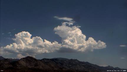
Arizona (See Fig.1.1)
![]()
There is a growing body of evidence that cumulus congestus
eventually are transformed into cumulonimbus as an ensemble of plumes or
thermals eroding and detraining to various degrees.
Over the
Santa Catalinas Mountains, convection typically begins at around 9:00am local
time. In spite of there usually being sufficient convective available potential
energy (CAPE) to support deep convection, the convection develops in stages. Shallow convection builds, first into a
cluster of turrets growing to the cumulus congestus stage and then, in many
cases, into cumulonimbus. In general, the transition from the first time that
BL convection reaches saturation (i.e. cloud appearance) to the appearance of a
thunderstorm over the Catalinas is about 3 hours. In many cases, the orographic
thunderstorm dissipates or moves from the top of the mountain and a second
episode of convection begins, with a transition from shallow to deep convection
occurring on a similar time scale.
The transition
from shallow to deep convection is not confined to the sky islands, and has
been described for mid-latitude maritime cumulus and tropical trade wind
cumulus by Malkus and Scorer (1955). Blyth and Latham (1993) show that the
cumulus congestus which forms over the New Mexico mountains undergoes cycles of
growth and decay with new convective turrets ascending through the remnants of
the old ones.
One possible explanation
for the behavior described above is related to the entrainment of environmental
air into the ascending current. The mixing of relatively dry environmental air
into the saturated air causes the clouds to dissipate. Entrainment erodes
cumulus buoyancy in proportion to
the dryness of the ambient air. The invisible plume of moist air that results
from the detrainment and decay of initial convection shields subsequent
towering Cu from erosion by entrainment. The details of this process depend on
how and where air is entrained, the level and horizontal distribution of where
the cloudy air is deposited (detrained), the extent to which these processes
modify the environmental thermodynamic profile, and the ratio of the cumulus
detrainment timescale to the advection timescale.
The fundamental scientific hypotheses around which CuPIDO
is based are :
The onset of orographic convection results from the
convergence of boundary layer over the mountain and local surface heat fluxes,
leading to local boundary-layer deepening to the level of free convection
(LFC).
Local surface fluxes of latent and sensible heat at and
around the top of the mountain begin as the net radiation increases. This warms
and moistens the boundary layer, and increases the equivalent potential
temperature qe . The notion of a
convective deficit, introduced by Raymond (1995) defines a threshold value of qe based on the surface value and the saturated value qe* in the vicinity of the cloud base (the
Lifting Condensation Level, LCL).
The local fluxes are augmented by the transport of warm,
moist boundary layer air from the valley via the mesoscale upslope flow. The
total time tendency of the boundary layer qe
is determined by surface fluxes of latent and sensible heat along the sides and
top of the mountain, and the transport of low-level boundary layer air. The
strength of the orographic circulation, thermodynamic characteristics of the
boundary layer air, and the previous history (i.e. the early morning value of qe) determine the timing of the onset of convection.
Dry convection may act to modify the temperature profile and
remove some of the convective inhibition (CIN) present in the morning sounding.
Since in general the LFC is only just above the LCL, the appearance of shallow
cumuli implies that ambient CIN has vanished. The shallow cumuli represent
entraining boundary-layer thermals. Their vertical momentum is largely
buoyancy-driven, although some forced ascent may result as the mesoscale
anabatic or large-scale flow rises over steep terrain.
Subsequent development of the convection and thunderstorm
development is governed by mutual interaction of cumulus and the environment
Once the convective deficit has been eliminated, shallow
convection develops and convective turrets eventually begin to grow. Dry air
aloft is entrained into turrets and they evaporate. However, the shallow
convection can, in certain circumstances, moisten the column above the terrain.
Subsequent convection rises through the remnants of the old convection and the
air that is entrained is less dry, allowing the new convection to penetrate
deeper. The successive deepening of the convection leads eventually to
precipitating cumulonimbus. The extent to which conditioning of the column
occurs depends on the thermodynamic and shear profiles of the environment.
Shallow convection moistens column above the mountain and provides conditions for development of deep convection. In the process, some CAPE is consumed, but the conditioning that occurs via the shallow convection allows the remaining CAPE to be used more efficiently. As deep convection develops, the mesoscale upslope flow is enhanced by buoyancy-induced pressure reduction. As deep convection matures and a cold pool develops in the boundary-layer, the upslope flow is temporarily blocked. This dynamic synergy between towering cumulus convection and orographically-induced mesoscale circulations determines the timescale of subsequent convective development.
The successive development of cumulus turrets over the mountain, combined with cloud radar and stereophotogrammetry observations at a resolution sufficient to capture entrainment events, set the stage to gain new insights into the fundamental dynamical mechanisms controlling the evolution of cumuli.
The cloud radar captures the echo and kinematic structure of orographic cumuli at a scale of
about 40 m, sufficient to resolve the primary entrainment processes. These are interpreted
in light of in situ microphysical and thermodynamic data. While the UWKA
and WCR capture snapshots, the temporal dimension is covered by stereophotogrammetric observations. The
abundance of soundings will allow an assessment of the effects of shear and
static stability on entrainment, and a more accurate estimation of buoyancy.
1.2 Relation to previous field studies
Aspects of the orographic circulation and accompanying convection associated with sky islands in the Southwest US have been documented in a number of studies. Fujita et al. (1962) used a mesometeorological network consisting of microbarographs, hygrothermographs and wind recorders located on San Francisco Mountain in Northern Arizona to examine moisture inflow associated with the cloud formation. They found an area of surface low pressure developed on the heated side of the mountain slope that provided low-level convergence that led to the morning cumulus convection. The low eventually dissipated as the deep convection developed.
The Fujita et al. (1962) study followed work by Braham and Draginis (1960) who used radar and airborne instruments to study the orographic cumulus over the Santa Catalina Mountains, which are the focus of CuPIDO. They showed that the elevated terrain was essential to increasing the potential temperature in the free atmosphere over the slope. The flight data revealed the existence of a convective core located over or slightly downwind of the peaks, with an accompanying moisture anomaly and nearly adiabatic lapse rate that is in contrast to the slightly stable environment.
A later and more comprehensive series of field observations was performed over the Magdelena Mountains in Central New Mexico by personnel from the New Mexico Institute of Technology. This region also experiences a summertime precipitation maximum associated with the North American Monsoon. The dry orographic circulation in the pre-monsoon phase (Raymond and Wilkening, 1980) and the resulting moist flow and accompanying convection (Raymond and Wilkening, 1982) were examined separately. These experiments were carried out with data obtained primarily from an instrumented aircraft. The key objective of these studies was to estimate the horizontal moisture, mass, and heat fluxes around the mountain.
Raymond and Wilkening (1980) found an orographic flow similar to that in Braham and Draginis (1962), with a toroidal circulation of ~20 km in diameter that is driven by 3-4 km convective eddies. Mean heat fluxes of ~400 W m-2 over the convective core were common, with values as high as recorded. This suggests that the mountain is collecting solar heat from a region larger than its actual area, implying that local fluxes as well as the orographic flow are important in determining the energy budget. There is also evidence of negative heat fluxes above the convective core that also highlights the importance of the orographic circulation in the overall energetics.
In a series of flights performed later in the season, after the onset of the monsoon and in order to assess the effects of moist convection on the orographic flow and to consider aspects of the convective development. Raymond and Wilkening (1982) found that the presence of cumulus convection or early stage thunderstorms didn’t appreciably change the strength of the orographic circulation. There was also net divergence around the clouds up to a height of about 6 km MSL, which the authors suggest favors a vertical mixing model of cumulus clouds. Further evidence of vertical mixing was demonstrated by Paluch mixing diagrams based on aircraft soundings.
In a later study Raymond and Wilkening (1985) highlighted
differences in orographic thunderstorms and cumulus congestus through composite
soundings and budget measurements using data taken with the NCAR Sabreliner.
The composite temperature profiles were similar, while there were large
variations in the mid-level moisture. The mid level moisture was larger by
nearly a factor of 2 at the 500 mb level for thunderstorm versus the congestus
cases. Composite source terms of
various quantities show that the congestus clouds dry the subcloud layer (below
about 650 mb) and moisten the cloud layer. There is also a warming confined to
below the 500 mb with a peak at about 700mb. In contrast, the thunderstorms dry
from the surface to about 400 mb, with warming occurring between the cloud base
and the 200 mb level.
1.3
Photogrammetric techniques for studying cumulus development
The influence of mid-level moisture on
convective development has been given considerable attention lately. This is
motivated by the fact that clouds developing in drier environments may
experience stronger buoyancy reversal due to entrainment of the dry air (Grabowski,
1993 and Grabowski, 1995). Brown and Zhang (1997) show that dry air above the
boundary layer limits cloud top heights and leads to temporary break periods in
the monsoon over the west Pacific warm pool. Over the tropical oceans, the
surface forcing is relatively weak compared to the surface heating occurring
over the mountains in Arizona, and thus the CAPE small, hence the ability of
the convection to modify its environment may be limited there. But in the
absence of wind shear it is conceivable that mid-level moistening by successive
penetrations of congesti leads to deep convection.
The importance of moisture variability on
convective development has been illustrated in a number of papers utilizing
data collected over Florida during the CaPE (Convection and
Precipitation/Electrification) experiment. Weckwerth et al. (1996) showed that the
helical roll circulation in a sheared convective boundary-layer modulates the
BL depth and vertical profiles of temperature and moisture . Observed cloud
bases (i.e. the LCL) corresponded to moisture values measured by aircraft in
convective roll updraft regions. Weckwerth (2000) showed that operational
soundings did not differentiate between storm and no-storm days, but when the
soundings were adjusted to conditions in convective roll updraft regions using
aircraft data, profiles were then
useful predictors of thunderstorm initiation. Crook (1996) demonstrated the sensitivity of moist
convection to low-level thermodynamic parameters using a high-resolution
numerical model. Modifications of CIN and CAPE of model temperature profiles
consistent with observational uncertainty resulted in either no triggering or
intense convection.
The onset of convection is due to destabilization of the
boundary through a combination of lateral (upslope in this case) transport and local
surface fluxes of latent and sensible heat over the mountain, creating an
elevated convective BL. The details of this issue will be discussed later. However, once the convection begins to
build, there is variability of the development rate that is based on
environmental conditions.
The notion of obtaining quantitative information from
visible cloud images is not new. Early studies by Malkus (1952) used a
labor-intensive manual technique of projecting slides onto a sheet and tracing
the cloud outline. While this technique does yield useful results, it is time
consuming and processing large numbers of cases is unwieldy. Automatic image
processing techniques developed at Arizona State University are being used to
determine a proxy for volume of cloud in a given frame and a time series of
these describes the development of the convective cluster.
Some preliminary results of this analysis technique are
presented by Zehnder et al. (2005), and are summarized below. A simple metric
of cloud development is determined from automatically segmented visible
spectrum images of convection over the Santa Catalina Mountains. The total
number of pixels in the frame is plotted as a function of time, along with a
mountain top value of the equivalent potential temperature (qe).
The onset of the convection occurs when a threshold value of
qe is exceeded, with the
threshold value being based on the saturated equivalent potential temperature qe*
just above the cloud
base. The difference between these quantities is defined as the convective
deficit by Raymond (1995) and represents the threshold for deep convection over
the tropical oceans.
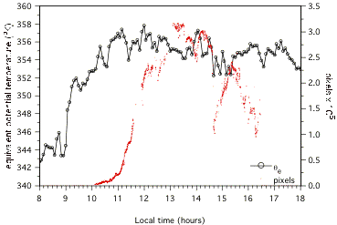
Figure 1.2: Convective development on 23 July 2003. In this case, there is a continuous but
variable development of convection once a surface value of qe of 353K is reached.
The convection builds and then dissipates, but there is a slow and steady
development over a five hour period.
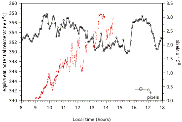
Figure 1.3: Convective development on 25 July 2003. There
the convection again begins once the a surface value of qe of 353K is
reached. The threshold value is exceeded later, and this is due to the
generally lower values of qe earlier that morning. Once
the convection begins, the growth rate is slower but more consistent than on
the 23rd. However, once the deep convection begins to build (at
about 11am) the growth rate is larger than on the 23rd, as is
indicated by the steeper slope of the cloud amount line.
1.4 Airborne cloud radar studies of cumulus dynamics
Cumulus
dynamics were studied for the first time with the UWKA and WCR in HiCu03,
conducted in the southeastern corner of Wyoming over terrain ranging from 1.2
to 2.4 km in altitude. The HiCu03
cumuli may have had roots over higher terrain, but the terrain influence was
not studied in HiCu03, in any event, the deep well-mixed CBL is similar that in
Arizona in summer. Cloud bases
were about 5.0 km MSL. Cloud depth
extended up to 3 km, with freezing levels around 4.4 km MSL. The horizontal aspect ratio of the
clouds was very close to one, with diameters on the order of 2-3 km.
|
|
|
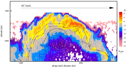
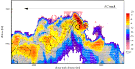
Fig 1.4 Two vertical-plane
dual-Doppler (VPDD) passes at the top of an isolated cumulus, on Aug. 26th,
2003, at 18:20 UTC (left) and 18:23 UTC (right). Shown are WCR reflectivity in
color (Zv, dBZ), 2D vector field (mean wind subtracted), and select streamlines
(black lines with arrows). The aircraft flew just above the cloud tops. Grid
resolution: 30x45 m2. The ‘reflectivity’ is the equivalent
reflectivity, i.e. it is assumed that the scatterers are water spheres. The WCR
vertical velocity is the particle vertical motion: the particle terminal
velocity (ranging between 0-3 m s-1, according to the in situ cloud
probes) is too uncertain to derive the vertical air motion field, but
relatively small.
The
observed (equivalent) reflectivity and velocity fields in Fig 1.4 confirm the conceptual model of shedding thermals (Blyth et
al., 1988). HiCu03 data show that
the upper portion of a cumulus thermal often consists of a rising vortex
ring. Entrainment can occur near
the ascending cap, consistent with the cloud-scale vorticity field: entrained
air, engulfed by fine-scale shear instabilities at the upper boundary, may be
carried downward along the side without penetrating into the ascending core
because of strong horizontal divergence at the top. Instead, the mixed or even purely ambient air is more likely
to be transported into the center of the thermal by the convergent flow at the
vortex ring base. At a smaller
scale (~100 m), both intrusions and extrusions can be seen, in which the velocity
field is generally consistent with the streamwise reflectivity gradient,
suggesting a short cloud microphysical response time.
This
picture is consistent with the numerical simulations by Zhao and Austin (2004).
They confirm the presence of undiluted parcels at the very front cap of the
ascending thermal and in a narrow stem below it. Hydrometeors also may be drawn back
into the updraft via this recirculation.
This may be occurring at the base of the counterclockwise rotor in the
left image of Fig 1.4, for instance.
Such recirculation may lead to rapid precipitation growth: ice crystals
may grow via Bergeron process when re-injected into an ice-supersaturated
region; and larger droplets may find themselves in an environment favorable for
coalescence. In other words, the
vortex circulation may augment the effective particle residence time, thus
facilitating both ice nucleation and riming/collisional processes.
The two
VPDD analyses in Fig 1.4 are separated by ~3 minutes. Low reflectivity values are found in the center of the
growing cumuli, while larger values occur at the summits and edges of the
cloud. During HiCu03, growing
cells systematically show centrally located updrafts, flanked by descending regions. This suggests a toroidal circulation:
upward motion in the center of the cloud, overturning and horizontal divergence
at the top, and descending flow carrying larger hydrometeors along the
sides. The vortex ring is
sometimes tilted by ambient shear. The arching pattern in the reflectivity structure
can be partly due to the lateral displacement of previously formed hydrometeors
caused by the divergence at the top of the thermal.
The
vortex ring core updraft carries aloft new generations of small droplets (mean
diameter <15mm), yielding weaker echoes. Vortex ring tops and edges appear to be areas favorable to
ice nucleation. Evaporative
cooling following mixing may contribute to droplet freezing. Coalescence or riming may be promoted
at the summit of the ascending parcel, if this parcel follows the path of a
previous updraft, and a new generation of droplets is forced against ‘older’
precipitation. Reflectivity maxima
were measured to increase by about 10 dBZ in 10 min in the growing cumulus of
Fig 1.4. Such rapid increase was
commonly observed in HiCu03 cumuli.
Even at temperatures around -18ºC, LWC (liquid water content) values
close to adiabatic were found in growing cumuli, above WCR-detected updraft
shafts. When the central updraft
becomes cut-off from its source, then the cumulus rapidly glaciates. This causes a rapid reflectivity
increase (5 to 10 dBZ), and the development of ample downdraft regions.
|
A |
B |
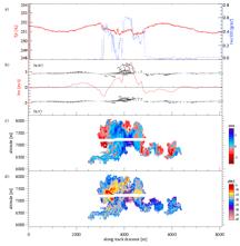
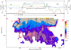
Fig 1.5 A) In
situ and WCR analysis of an isolated congestus, July 13, 2003, 20:58 UTC. a)
density temperature (Emanuel, 1994) (Tr) and
liquid water content (lwc); b) air vertical velocity (hw) and gust vectors
(deviations from the mean horizontal wind) in the vertical transect (u,w) and
the horizontal (u,v); c)Doppler vertical velocity above and below flight level
(the white stripe is the radar blind zone); d) reflectivity. B) As Fig 1.4, but for a young
congestus on July18, 2003, 20:43UTC; upper panel shows in situ data: air
temperature (trf), air vertical velocity, liquid water content, FSSP cloud
particle number concentration (FSSP), and gust vectors in the horizontal plane.
Circulation
driven entrainment is illustrated further in Fig 1.5. Fig 1.5A presents in situ and WCR measurements in up/down
profile mode. Again vortical
kinematics can explain the overall mushroom shape of the cumulus. The Doppler field shows an updraft
located in the central portion of the cloud, near its base. The precise cloud
base cannot be detected by the WCR, because of the small droplet size and the
likely presence of insect scatterers across the cloud base, but it can be
estimated well with both photogrammetry and surface/upper air data in CuPIDO. Vertical
plane wind vectors reveal the overturning of the thermal: a counterclockwise
circulation is visible in the left sector of the cloud with convergent flow
towards the center at flight level.
Stronger reflectivity echoes are evident within the downward motion
region. Some dry air appears to be
captured by the circulation on the left: low reflectivity values intrude the
cloud from the side and bottom.
Note how the flight-level LWC drops to zero where this entrained air is
encountered, near x=3600.
Fig 1.5B illustrates a VPDD
synthesis of another cumulus top.
Again an intense vortical structure is identifiable on the right, with
potential entrainment manifesting in the reflectivity dent, consistent with a
LWC minimum at flight level, well to the left of the cloud edge. During the next pass, six minutes
later, the cloud was in decay; ice was widespread across the cloud and the
maximum LWC had been reduced by a factor of three.
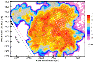
Fig 1.6 As Fig 1.4, but a horizontal-plane dual-Doppler (HPDD)
analysis of a congestus on July 12, 2003.
Fig
1.6 offers a horizontal view. Two large counter-rotating vortices are
visible in the upper right and lower left. The large dent in the cloud boundary on the right
illustrates entrainment driven by the cloud-scale circulation, while the
divergent flow in the upper left cloud patch, away from the main cloud,
suggests that that patch is detraining.
Horizontal-plane vorticity, deformation, and divergence are comparable
to those observed in vertical transects, which is consistent with the ~1:1
cumulus aspect ratio. Clearly the
3-D vorticity vector shows no preferential orientation in the vertical, and can
be readily tilted into the horizontal; e.g. the counter-rotating vortex pair in
Fig 1.6 may be due to the tilting of ring-core vorticity by the ambient
wind. Vertical vorticity is
frequently found at the edges of the updraft core.
During HiCu03, clouds appeared characterized by a pulsating
nature, with periods of ‘inactivity’ alternated by arousal of coherent and
vigorous updrafts. A more complete description can be found in Damiani et al.
(2005). These illustrations highlight the complex 3-D nature of entrainment
mechanisms and cloud development processes. The WCR is a formidable tool to tackle these problems,
especially when combined with in situ cloud, thermodynamic, and velocity data.
In CuPIDO we aim to further examine entrainment processes
and the pulsating nature of convection. We hope to quantify the
buoyancy-eroding effect of entrainment events and place them in the context of
core buoyancy, which can be estimated better because of the detailed
description of the environment during CuPIDO. We may be able to measure
pressure perturbations in and around cumuli based on a new GPS method.
Shallow to deep convection is well-known to develop over mountains during the warm season. The ‘sky islands’ in the American Southwest are a preferred natural laboratory for cumulus studies, given the spatially and temporally regular development of cumuli driven by surface heat fluxes and mesoscale circulations. Cumulus convection is of fundamental importance to the atmospheric circulation. It transfers heat, moisture and momentum across isentropic surfaces in the troposphere. It profoundly impacts the local and large-scale radiation balance and is responsible for much of the warm-season precipitation.
CupIDO will advance science and predictability on several, related fronts:
(1) fundamental cumulus dynamics
A number of contrasting conceptual theories exist for the dynamics of cumulus convection, yet thorough observational evidence remains rather sparse. CuPIDO will revisit many aspects in the series of studies described in the preceding section with the advantage of 25 years of advances in technology. Specifically, we will be able to characterize the detailed structure of the convective clouds at any instant using photogrammetric data and for selected cases, Doppler radar measurements. The combination of airborne in situ data with cloud radar measurements adds a new dimension to the study of cumulus dynamics. We will also sample changes in the environment following convection, using GPS sondes, aircraft data, and hopefully water vapor profiles from various remote sensing systems that are proposed for CuPIDO.
CuPIDO measurements will visualize entrainment and
detrainment, allowing a quantitative estimate of their rates and its variation
with environmental conditions such as shear and moisture/stability in general.
(2) the orographic forcing of cumulus clouds
Data collected during CuPIDO will allow a characterization of orographic cumulus in the desert southwest, the evolution of the boundary layer over the desert sky islands (which has not been previously examined) and the relation mutual interaction between cumulus clouds and the environment during the transition from shallow to deep convection. This is a multi-scale process, and the synergy between topographically-induced mesoscale circulations and cumulus convection over mountains is poorly understood. We will also have a complete characterization of the surface forcing on the scale of the orographically induced uplifting. Further, the GPS based soundings and the UWKA in situ data will allow composite and flux budget analyses similar to that in Raymond and Wilkening’s series of papers that will be aided in interpretation by the details of the cloud structure.
(3) Parameterization of cumulus convection
Cumulus convection operates on a range of horizontal and vertical scales. These scales are generally not resolved by operational numerical weather prediction (NWP) models. Thus the simulation of its impact is most challenging, and convective parameterization remains one of the greatest uncertainties in NWP models. Currently the ETA model runs at a horizontal grid spacing of 12 km in the conus domain. The Santa Catalina Mountains are roughly 20 km in diameter, less than three grid spacings, which are needed for the mountains to be resolved. Even if current- or future generation NWP models are able to resolve the mesoscale circulations associated with the Western mountain ranges, the effect of cumulus convection will continue to be parameterized. CuPIDO observations and interpretation of orographic cumulus dynamics are expected to lead to a more accurate representation of the effect of cumulus convection on the resolved scales of NWP and general circulation models.
.
The primary scientific questions to be addressed center
around aspects of orographic convection in a desert environment and the mutual
interaction between cumulus convection and the environment in general. Specifically, we will explore the
hypotheses:
1) Shallow convection begins over
the sky islands through a combination of boundary layer destabilization and
organized orographic uplifting. The destabilization is due to mainly sensible
heat fluxes building a deep convective boundary layer over the surrounding plains,
and to anabatic boundary layer convergence and thus boundary layer deepening
over higher terrain. The relative contribution of local (mountain top) fluxes
of latent and sensible heat to the low-level moist entropy budget, in
comparison to upslope transport of ambient boundary layer air, is not clear and
probably varies during the transition from shallow to deep cumulus.
2) Deep convection and
precipitation occur through the conditioning of atmosphere by detraining and
decaying shallow convection. Shallow convection modifies the profile by
moistening, reduction of CINH and other factors. The timing of the transition from shallow to deep convection
depends on details of the interaction of between shallow convection and the
environment.
Processes related to 1) may be unique to orographic cumulus.
Processes related to 2) may be generalized to cumuliform
clouds in general and especially in a tropical environment, where the free
troposphere above the subsidence inversion may be dry and the shear is weak.
The destabilization of the boundary layer is due to contributions
of local (mountain top) fluxes of latent and sensible heat and warm moist
boundary layer being transported via the upslope flow. This can be
characterized in terms of a qe budget that will be determined using the
network of automated surface mesonet stations in the Santa Catalina Mountains,
and the existing 30 meter flux tower on Mt. Bigelow. The relative contributions
of forced meso-b scale uplifting and
turbulent mixing will be determined.
It has been documented (e.g. Zehnder et al 2005) that the
orographic cumulus develops slowly and in stages, with a distinct shallow
convection phase of about an hour duration, followed by a rapid development
phase that often results in cumulonimbus formation. One possibility for the
slow initial development is the diurnal change of static stability. It is
possible that the increase in the surface heating in the surrounding plains,
and accompanying orographic uplift and mixing may act to eliminate CIN in the
profile. This process may be due to the action of dry
convection, as the depth between LCL and LFC (i.e. the sub-LFC cloud layer) is
quite shallow. These questions
will be addressed using the sounding data, and vertical profilers if available.
A second possible role the shallow moist convection may play
is to condition the profile by moistening. That is, the non-precipitating shallow
convection detrains BL water vapor into a drier environment. Subsequent
convection rises through the remnants of the old cells, but the air is less dry
and hence there is less erosion of the cells via entrainment. In this case,
there may be a reduction of CAPE due to the warming and moistening of the
column above the mountain, but the moistening allows the remaining CAPE to be
used more efficiently. This mechanism would depend critically on details of the
environment, and particularly the vertical shear, since the residence time of
parcels over the terrain is important. These issues will be addressed using
sounding and in-situ data from the Wyoming King Air.
A third mechanism through which shallow convection may
condition the atmosphere for deep convection is through the initiation of the
ice phase. Observations in HICU03 and elsewhere indicate that the glaciation process
can be rapid. Ice crystals from shallow to mid level convection entrained into
new turrets, accelerating the glaciation in these turrets. Contributions from Lfreeze
and Lsub > Lvap
to the temperature evolution may provide more positive buoyancy (Koenig
1963) . In this case, the exact stage in the evolution and the level at which
the clouds become glaciated is important.
The presence of an ice phase is also important to the cloud
electrification. This aspect will
be addressed by in-situ data collected from the Wyoming King Air during cumulus
penetrations.
In addition to the aspects of convective triggering and the
interaction of cumulus clouds with the environment that leads to the transition
from shallow to deep convection, we will also examine other general aspects of
cumulus convection. Specifically,
the behavior of individual thermals in the context of similarity theory which
states that the entrainment rate at
cloud edge proportional to vertical velocity and inversely proportional to
radius of thermal will be examined.
Also, there have been predictions, primarily based on the behavior of
laboratory thermals, that vertical velocity/buoyancy vary with vertical
distance from source via a power law. We will be able to determine if these
results hold in the presence of latent heat release.
Having the Wyoming King Air and Wyoming cloud radar will allow us to extend previous studies by examining the detailed evolution of convective cells. The radar data will also provide validation for the image analysis and eventually develop a long-term database derived from the digital cloud images.
The following specific aspects of cumulus dynamics will be addressed:
• What conceptual model
best describes the formation stages of a convective cloud?
– Is orographic
convection pulsating ?
– How does the
cloud-top ascent rate compare to the core’s updraft speed?
– Which element does
the updraft mostly resemble: steady jet, starting plume, shedding thermal?
• What are the typical
fine-scale flow and vorticity patterns within a cumulus congestus?
– Are there
secondary circulations along the main updraft column, such as horizontal/tilted
vortex rings?
– What are the space
and intensity scales of vortices in the horizontal plane?
– How do the
horizontal airflow patterns influence the turbulent meandering of the updraft
and affect the particle residence time?
• Are there indications of
significant hydrometeor re-ingestion into the updraft core?
• Where and at what scales
does entrainment occur?
– What is the role
of major and secondary circulations (esp. the toroidal circulation) in the
entrainment?
– How do radar
entrainment signatures at all scales evolve as a cumulus tower grows?
– Do undiluted
parcels persist in some cloud regions?
• Can cloud top
instability nodes be discerned with WCR data?
• How important is the vertical wind shear in the evolution of the characteristic flow structures associated with the convective parcels?
The following questions about the synergy between mesoscale circulations and orographic convection are addressed:
·
Is convective initiation driven by local surface heat
fluxes over the mountain, and/or by mountain-scale convergence of air and
moisture? How does this
convergence change in intensity and in vertical extent during the orographic
cumulus development phase?
·
Does the free troposphere, above the CBL, warm over the
mountain as a consequence of the cumulus convection? In assessing changes in
the ‘environment’ in which a sequence of cumulus towers detrain, care needs to
be taken to discriminate both horizontal and vertical advection: an increase in
q can be due to detrainment of ‘parcel’
air, or to compensating subsidence.
·
Does the water vapor over the mountain increase as a
consequence of the cumulus convection, i.e. do successive waves of cumulus
significantly detrain moisture, as suggested by Perry and Hobbs (1996)?
·
Is the gradual deepening of successive cumuli leading
to the Cb stage caused by moisture detrainment, rather than by the continued
warming along the mountain slopes?
CuPIDO will consist of an extended observing period (EOP) beginning on July 1, 2006 and ending on August 31, 2006. During this period, there will be a stereo pair of cameras operated at the Biosphere 2 facility, with an additional camera located about 5 km to the south in a residential area. We will also operate an additional stereo pair of cameras on the east side of the mountains in conjunction with one of the surface meteorology stations described below. The EOP will also include a network of 10 portable automated mesonet (PAM-III) stations that include standard meteorological observations. Four of the PAM stations will be equipped with sonic anemometers provided by the NCAR Integrated Surface Flux Facility (ISFF) and will provide fluxes of latent and sensible heat. The flux measurements will augment observations from a 30 meter tower operated by the University of Arizona and located at the top of Mt. Bigelow in the Santa Catalina Mountains. The Mt Bigelow tower height is justified by the high forest canopy on the mountain top. The ISFF station measurements will measure at 10 m AGL (???), which is sufficient for the shorter vegetation at sites on the mountain slopes.
Between 18 July and 17 August, 2006 a series of additional Intensive Observing Periods (IOPs) will be performed that will include two Global Atmospheric Observing Systems (GAOS), which are GPS based radiosonde systems using the Vaisala RS-92 radiosonde. We have 100 radiosondes allocated for the project. There will also be a series of research flights performed by the University of Wyoming King Air with 95Ghz (W-band) radar. 60 flight hours have been allocated. During the IOPs the standard observing platforms (digital cameras and PAM/flux stations) will be operated. Given the flight duration of the WKA (four hours), we will perform approximately 15 IOPs.
4.2 Surface and upper air observations
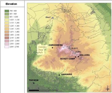
The location of digital cameras, PAM-III and ISFF stations and potential sites for the GAOS systems are shown in Figure 4.1.
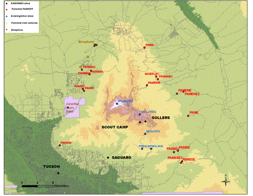
Figure 4.1: Locations
of existing facilities and proposed sites for PAM-III and flux stations.
One site for PAM-III and ISFF stations will be chosen from amongst the clusters shown in Fig. 4.1. These exact locations will be based on a site survey that will be performed prior to the field experiment that will determine feasibility of line of site microwave communications with base station that will be located at the top of Mt. Lemmon.
The PAM-III stations will provide measurements of wind, temperature, humidity, pressure, net radiation, and precipitation. At flux sites, fluxes will be measured by means of high-frequency temperature and humidity sensors, and a 3D sonic anemometer. These sites will house a UV absorption hygrometer, IR H2O/CO2 analyzer, prop-vane anemometer, hygrothermometer, pressure sensor, net radiometer, pyranometer, pyrgeometer, surface temperature sensor, soil temperature sensor, soil moisture and precipitation. Five minute averaged observations will be provided in real time and raw data at 20 Hz will be recorded via data loggers at each station and will be available for post field phase processing.
Upper-air observations will be provided by two GAOS stations, one of which will remain stationary and one mobile station. The latter will be positioned just downwind of the mountains, thus yielding insights into how deep convection alters the environment. The mobile system will be located either to the west or northeast of the Santa Catalinas depending on the prevailing wind conditions. During some of the IOPs a GAOS system will be located in the vicinity of the Rincon Mountains in order to sample the far upstream contributions to the evolution of the thermodynamic profile over the Santa Catalinas. The Rincons are a mountain feature of comparable elevation and horizontal scale to the Santa Catalinas that are located to the southeast (upwind) about 50-60 km.
The stationary GAOS system will be located at the Molino Basin campground in the Coronado National Forest (see Fig. 4.1). This area is located to the southeast of the peaks, and during typical monsoon conditions with deep southeasterlies the sondes will be carried over the region where the convection is developing, thus providing the best estimate of environmental conditions leading to convective initiation.
The optimal spacing of stereo pairs of cameras provides a 1-30 ratio of separation to distance. At the distances from the terrain that we have been operating cameras, this is a separation of around ½ km. The image analysis techniques provides a three dimensional structure of one side of the cloud. In order to provide a full 3-d structure of the convection cameras will be operated on the east side of the Santa Catalinas. Cameras will be co-located with one of the PAM-III stations, with power being provided by solar panels and communications via the NCAR microwave link. The IQEye3W camera has an optional PC card slot that will accommodate a flash drive that will hold about a week’s worth of images. This will be used as a back up to the real time data transfer.
Flights will be dedicated to cloud
scale as well as meso-g scale investigations of orographic cumulus
development. At this stage we
foresee to utilize the available flight hours with an emphasis on the cloud
kinematics and dynamics, dedicating a larger portion of the flight segment to
cloud penetrations and radar scanning mode fly-bys. However, depending on the
type of convection and weather developments, we will extend a portion of the
daily flight to better characterize the modification of the mid-troposheric
environment by the successive cumulus pulses.
Temporal (rather than just statistical)
sampling is essential to assess conceptual
models of cumulus growth. Owing to the orographic locking of the convection, we
should be able to perform multiple rapid scans of the same cloud. We plan to sample cumulus cloud with
depths ranging from shallow (0.5- 2 km) to towering (congestus, up to ~ 4 km
deep). If the cloud does not over-develop, but rather collapses in favor of new
turrets, we will also be able to collect a statistically meaningful sample of
various cumulus features. The accurate planning of flight patterns is a key to
the success of the experiment. In particular these objectives dictate the rules
of flight/cloud engagement:
1.
Mesoscale circumnavigation
(for budget studies)
2.
Characterization of the
kinematics:
2.1 Assessment of the main field structures in both vertical
and horizontal planes, and of the coupling between the two planes
2.2 Classification of flow properties with respect to vertical
levels: several scanning passes at the same level and at least for four cloud
levels: subcloud layer, cloud base, mid-depth, cloud top
3.
Characterization of
thermodynamic/microphysical quantities at different levels (subcloud layer,
cloud base, mid-depth, cloud top)
4.
Characterization of
reflectivity structure variability within vertical and horizontal planes
5.
Time evolution of convection
The King Air will be airborne prior to the first cumulus
appearance. During the ferry the aircraft will execute a sounding up to about 3
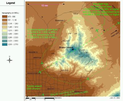
km AGL and a low-level mesoscale circumnavigation of the mountain (Fig 4.2). The total estimated time to complete this segment
of the mission is approximately 30 minutes (100 km circle around the mountain,
see Fig 4.2).
Fig 4.2. Flight patterns aimed at describing the interaction
between orographic cumuli and their mesoscale environment.
The convection is usually locked
on preferential topographic areas and develops in stages:
shallow-to-deep-convection transition usually spans across three hours.
In the initial stages of
evolution the continental cumuli will
likely be only marginally detectible by the WCR, and the strategy is to
characterize the subcloud layer with cross-wind
passes at about 200 m below cloud base,
mostly relying on on-board instruments (Fig 2). Estimated
flight-segment required time: 10-15 minutes. The WCR will
be run in up/down profile mode (scanning a vertical plane above and below
flight level). In case of scatterers such as insects or other types of debris
be present, the WCR will capture the CBL top, echo plumes, and updraft columns
from ground level to echo top. Sampling of the subcloud air mass will be used
to understand CI (or CI resistence) and measure the adiabatic liquid water
path. Entrainment assessment calculations will also rely on these data.
The next phase consists of
penetrations at 200 m above base. The WCR
will be scanning a vertical plane above and below the aircraft and a starboard
horizontal plane. We foresee to find good data for droplet activation problem
closure and to be able to characterize the kinematics of cloud base
(convergence, updraft strength and location). Estimated flight segment time: 10
minutes (~4 2’-legs).
As the cloud develops into a weak
congestus, passes along the same line will be executed near cloud top in VPDD
mode. Then if the tower out-climbs the aircraft there will be chances to
perform HPDD passes grazing the edges alternated by VPDD or side-down modes (see Fig 4.3) penetrating the cloud. Estimated required
time: 20 minutes.
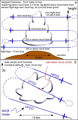
Fig 4.3. Flight patterns aimed at studying fundamental
cumulus dynamics. (a) Vertical transect showing a stepped traverse; (b)
Combination of traverses and side-swipes, with the WCR in vertical and
horizontal plane dual Doppler (VPDD and HPDD), respectively.
With the cloud at a congestus
stage, a further up/down/side penetration and/or dual-plane dual-Dopller (DPDD)
D will be executed at mid-cloud-level. Then the aircraft will climb again to
the top of the tower and complete passes in VPDD and HPDD. Estimated required
time: 20 minutes. Alternating between HPDD and VPDD, an
up/down WCR view is needed for the spatial collocation of the various features
in the horizontal plane with respect to the updraft/downdraft regions. All flight legs should maintain the
same orientations, along the shear vector if shear is present.
In case of multiple mid-size
towering clouds, the operation might be repeated once. Both at an early and at
a late stage, 40 km long legs will be flown at two levels, one near cloud base
and one at the estimated level of maximum detrainment, in order to assess how
the cumuli affect the environment (Fig 4.2).
The aircraft will divert back to
base when the convection becomes deep (cumulonimbus) or lightning is
observed. One more mountain
circumnavigation will be performed if conditions permit.
4.4 Forecast support and data management
An operation center will be located on the University of Arizona campus. This center will contain workstations for viewing real time NWS observations, model output and special forecast products.
Forecast meetings will be held in the late afternoon, in part to review the day’s IOP and also to plan potential activities for the following day. A first guess at conditions for the following morning (i.e. wind direction and thermodynamic profile) will be obtained from the NCEP/ETA and RUC models and also from real time runs of the WRF model that will be run at the UA campus. A second meeting will be held at approximately 6:30am the following morning where a final decision will be made for an IOP based on the 12UTC TUS sounding.
Emphasis will be placed on performing IOPs on “marginal” monsoon days, that is days in which there are clear and calm conditions at and just after sunrise and where the convection develops relatively slowly. These days seem to be associated with relatively dry air at mid-levels, and relatively little CAPE (Zehnder et al., 2005). Marginal days will be emphasized for a variety of reasons. First, the convection develops slowly and with a clearly defined shallow convection phase followed by a transition to deep convection. This is behavior is part of the central hypotheses of CuPIDO, and the automatic segmentation works best under these conditions. Marginal days are also desirable in terms of Wyoming King Air operations. Care must be taken not to operate the aircraft under conditions where there is lightning activity and the marginal days will allow a window of several hours of safe operation. In order to examine how successive convection conditions the environment, days with weak wind and wind shear are preferred. The mesoscale orographic circulation also is best developed and most symmetric on such days.
Flight operations using the NCAR Sabreliner described by Raymond and Wilkening (1985) had the aircraft based in Albuquerque, NM which is about 120 km northeast of the Magdelena Mountains. The aircraft was typically launched when the clouds were observed to reach towering cumulus or cumulus congestus stage. This, along with the ferry time resulted in a fair amount of convective modification of the environment prior to sampling. Given the objectives of that study, which was a characterization of mass, moisture and energy budgets associated with deep convection, this was a reasonable strategy.
We wish to sample the preconvective environment and the evolution of the convective core associated with the orographic uplifting, hence we attempt to begin flight operations prior to the onset of convection. One strategy would be to begin the flights sufficiently early, e.g. 8:00am local time. There is a fair amount of variability in the timing of convective onset particularly on marginal monsoon days, and this would result in long periods of operation in clear air. In order to optimize the amount of time devoted to sampling the convection with the UWKA, we will attempt to predict two milestones, i.e. the first cumulus appearance and the first cumulonimbus.
Zehnder et al. (2005) showed that convection began as the convective deficit defined by Raymond (1995) was reduced to zero. This quantity will be determined in real time based on the 12UTC TUS sounding and values of qe measured by the UA flux tower. Estimating the time tendency of qe will allow us to estimate the onset of convection and minimize the time spent operating in clear air.
The data archive is currently under development. Data and products to be archived wll include:
- all experimental data (direct archive or link to the P/I website)
- all real-time simulations (UA WRF and ETA)
- all GOES data in a rather small sector (maybe 500x500 km centered on Tucson)
- the level II TUC WSR-88D data
- operational surface and upper-air data in southern AZ
- additional surface data around the Tucson/San Pedro area
Several graduate students will participate, both during the field phase and in the subsequent data analysis. One PhD student has been identified at the University of Wyoming (Cory Demko). In coordination with NCAR ATD, we may write an REU (Research Experience for Undergraduates) proposal to fund undergraduate students from UA, ASU, or UW in the field, in order to operate the GAOS and maintain the PAM-III sites.
Blyth, A.J. and J. Latham, 1993: Development of ice
and precipitation in New Mexican summertime cumulus clouds. Quart.J.Roy.Met.Soc., 119, 91-120.
Braham, R.R. and
M. Draginis, 1960: Roots of orographic cumuli. J. Meteor., 17, 214-226.
Brown, R.G. and
C. Zhang, 1997: Variability of midtropospheric moisture and its effect on
cloud-top height distribution during TOGA COARE. J.Atmos.Sci., 54, 2760-2774.
Crook, N.A.,
Sensitivity of moist convection forced by boundary layer processes to low-level
thermodynamic fields. Mon.Wea.Rev., 124,1767-1785.
Fujita, T., K.A.
Styber and Rodger A. Brown, 1962: On the mesometeorological field studies near
Flagstaff, Arizona. J.Appl.Met, 1,
26-42.
Grabowski, W. W.,
1993: Cumulus entrainment, fine-scale mixing and buoyancy reversal. Quart.
J. Roy. Met. Soc., 119, 935-956.
Grabowski, W. W.,
1995: Entrainment and mixing in buoyancy reversing convection with applications
to cloud-top entrainment instability. Quart. J. Roy. Met. Soc., 121, 231-253.
Koenig, 1963:
Malkus, J.S.,
1952: The slopes of cumulus clouds in relation to external wind shear. Quart.J.Roy.Met.Soc., 78, 530-542.
Malkus, J.S. and R.S. Scorer , 1955: The erosion of
cumulus towers. J. Meteor., 12,
43-57.
Raymond, D.J.,
1995: Regulation of moist convection over the west Pacific warm pool. J.Atmos.Sci, 52, 3945-3959.
Raymond, D.J.,
and M.H. Wilkening, 1980: Mountain induced convection under fair weather
conditions. J.Atmos.Sci., 37,
2693-2706.
Raymond, D.J.,
and M.H. Wilkening, 1982: Flow and mixing in New Mexico mountain cumuli. J.Atmos.Sci., 39, 2211-2228
Raymond, D.J. and
M.H Wilkening,1985: Characteristics of mountain-induced thunderstorms and
cumulus congestus clouds from budget measurements. J.Atmos.Sci., 42, 772-783.
Weckwerth, T.M.,
J.W. Wilson and R.M. Wakimoto, 1996: Thermodynamic variability within the
convective boundary layer due to horizontal convective rolls. Mon.Wea.Rev., 124, 769-783.
Weckwerth, T.M.,
2000: The effect of small-scale moisture variability on thunderstorm
initiation. Mon.Wea.Rev., 128,
4017-4030.
Zehnder, J.A. et al. (2005): Using Digital Cloud Photogrammetry to Characterize the Onset and Transition from Shallow to Deep Convection Over Orography. (submitted to Mon.Wea.Rev. and available from http://geography.asu.edu/zehnder/manuscripts.html )