Regional Hydroclimate Project:
-
Other
-
ARM TWP
-
C2 Nauru
-
Name: Raymond McCord
Affiliation:
-
Oak Ridge National Laboratory
-
Building 1507
PO Box 2008, MS 6407
Oak Ridge, TN 37831-6407
Telephone: (865) 574-7827
Fax: (865) 574-4665
-
Latitude: -0.52100
Longitude: 166.91600
Elevation: 7.1 m
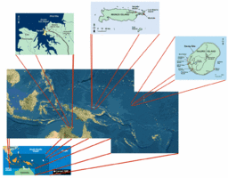
TWP Regional Map (click for full resolution):

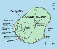
TWP C2 Nauru Area Map (click for full resolution):

Google Earth .kmz file of Other TWP Reference Site stations and radiosonde sites
Station Description:
-
General Description:
The Tropical Western Pacific (TWP) locale was established in 1996 as the second ARM Climate Research Facility site. Operated by the Tropical Western Pacific Office (TWPO) at Los Alamos National Laboratory, the TWP site consists of three climate research facilities: the Manus facility on Los Negros Island in Manus, Papua New Guinea (established in 1996); the Nauru facility on Nauru Island, Republic of Nauru (1998); and the Darwin facility in Darwin, Northern Territory, Australia (2002).
It is situated in the Denigomodu district on Nauru Island, the Republic of Nauru, which is located in the western South Pacific, approximately 1,200 miles northeast of Papua New Guinea. The ARM Program selected this location because it is on the eastern edge of the Pacific warm pool under La Niņa conditions, which affect weather patterns in the Pacific.
Station Operator:
-
US Department of Energy
Vegetation and Land Use:
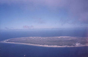
TWP C2 Nauru Aerial View (click for full resolution):

Dominant land cover at the measurement location: No information.
Canopy height: No information.
Density of Canopy: No information.
Land cover within 50 m of site: No information.
Land cover within 500 m of site: No information.
Land cover within 12 km of site: No information.
Seasonal land cover changes: No information.
Major changes in land cover at site from October 2002 to December 2004: No information.
Slope at the site: No information.
Aspect at the site: No information.
Other notes: None
Soil Type and Characterization:
Surface soil type: No information.
Soil type in deeper layers: No information.
Surface soil porosity: No information.
Soil porosity in deeper layers: No information.
Soil infiltration rate: No information.
Bulk Dry Density: No information.
Saturated Hydraulic Conductivity: No information.
The Soil Reference Group(s) (from World Reference Base for Soil Resources): No information.
Climate:
Nauru's climate is tropical, with daytime temperatures around 82° F (28° C), tempered by ocean breezes. Rainfall, averaging 81 inches (2,060 millimetres) annually, is extremely variable, and prolonged droughts occur. There is a monsoonal rainy season from November to February. Day time temperatures vary from 26 to 35 Celsius and nocturnal temperatures range from 25 to 28 Celsius.
-
SURFACE METEOROLOGY AND RADIATION INSTRUMENTATION AND DESCRIPTION:
- Station pressure - 1 m - Vaisala PTB201A digital barometer
- Air Temperature - 2 m - Vaisala HMP45D
- Dew point - 2 m - derived.
- Relative humidity - 2 m - Vaisala HMP45D
- Specific humidity - 2 m - derived.
- Wind speed - 10 m - R. M. Young Model 05106 Wind Monitors.
- Wind direction - 10 m - R. M. Young Model 05106 Wind Monitors.
- U wind component - 10 m derived.
- V wind component - 10 m derived.
- Precipitation - 2 m - Optical Scientific, Inc. Model ORG-115-DA MiniOrg or ORG-815-DA MiniOrg.
- Snow depth - Not measured.
- Incoming shortwave radiation - measured; height and instrumentation not provided.
- Outgoing shortwave radiation - measured; height and instrumentation not provided.
- Incoming longwave radiation - measured; height and instrumentation not provided.
- Outgoing longwave radiation - measured; height and instrumentation not provided.
- Net radiation derived height not provided.
- Skin temperature - measured; height and instrumentation not provided.
- Incoming Photosynthetically Active Radiation (PAR) - Not measured.
- Outgoing Photosynthetically Active Radiation (PAR) - Not measured.
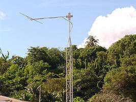
TWP Nauru Surface Instruments (click for full resolution):

- RS80-15GH (GPS windfinding, H-Humicap, 403 MHz) through May 2002
- RS90-AG (GPS windfinding, dual humicap) beginning June 2002
- RS92-SGP (SGP windfinding, dual humicap) beginning April 2005
METEOROLOGICAL TOWER INSTRUMENTATION AND DESCRIPTION:
-
No data of this type available at this station.
FLUX INSTRUMENTATION AND DESCRIPTION:
-
No data of this type available at this station.
SOIL INSTRUMENTATION AND DESCRIPTION:
-
No data of this type available at this station.
RADIOSONDE INSTRUMENTATION AND DESCRIPTION:
-
Location: 0.52S, 166.92E, 7 m
Production system: digiCORA-II (MW-15) s/n S35304
Assigned WMO station identifier (532 block 91)
Radiosonde Types Used:
-
Web:
-
None provided.
Literature:
-
None provided.
- GAPP Reference Site Status (10 March 2004; Irvine, California, USA)
- The USA, GAPP and CEOP (2 April 2003; Berlin, Germany)

