
-
MDB (Murray-Darling Basin)
-
Tumbarumba
-
Tumbarumba
-
None
-
Name: Dr Eva van Gorsel, Dr Ray Leuning or Dr Helen Cleugh
Affiliation:
-
CSIRO Atmospheric Research
-
PO Box 1666
Canberra ACT 6201
Australia
Telephone: +61 (0)2 6246 5611
Fax: +61 (0)2 6246 5560
-
Latitude: -35.65043
Longitude: 148.15125
Elevation: 1200 m
Tumbarumba Regional Map (click for full resolution):
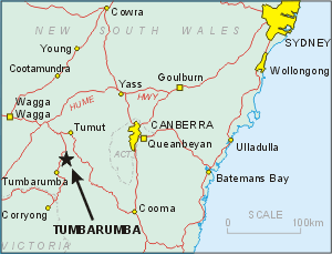
Tumbarumba Area Map (click for full resolution):

Google Earth .kmz file of MDB Tumbarumba Reference Site stations
Station Description:
-
General Description:
- Sensible Heat Flux - 70.00 m unknown instrumentation
- Latent Heat Flux - 70.00 m unknown instrumentation
- CO2 Flux - 70.00 m unknown instrumentation
- Soil Heat Flux - 5 cm depth Rebs HFT-3
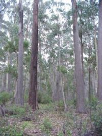
Bago State Forest, where Tumbarumba Flux station was established in March 2000,is a native forest of 50,000 ha that has been managed for wood production for over 100 years. It is a moderately open (Lai ~2.4), wet sclerophyll forest, 40 m tall, in which the dominant species are Eucalyptus delegatensis and Eucalyptus dalrympleana of mixed ages ranging up to 90 years.
Station Operator:
-
CSIRO
Bago State Forest, where Tumbarumba Flux station was established in March 2000,is a native forest of 50,000 ha that has been managed for wood production for over 100 y ears. It is a moderately open (Lai ~2.4), wet sclerophyll forest, 40 m tall, in which the dominant species are Eucalyptus delegatensis and Eucalyptus dalrympleana of m ixed ages ranging up to 90 years.
Tumbarumba Canopy (click for full resolution):

Dominant land cover at the measurement location: No information.
Canopy height: ~40 m.
Density of Canopy: No information.
Land cover within 50 m of site: No information.
Land cover within 500 m of site: No information.
Land cover within 12 km of site: No information.
Seasonal land cover changes: No information.
Major changes in land cover at site from October 2002 to December 2004: No information.
Slope at the site: No information.
Aspect at the site: No information.
Other notes: None
Soil Type and Characterization:
Soil Profile Morphology:
-
O1 0 - 0.02 m Organic Layer;
A1 0.02 - 0.08 m Dark reddish brown (5YR3/3-Moist); Mechanical, 2-10%, , Faint; Clay loam; Moderate grade of structure, 2-5 mm, Granular; Rough-ped fabric; Moderately moist; Very weak consistence; Field pH 4.5 (pH meter); Many, very fine (0-1mm) roots; Few, fine (1-2mm) roots; Common, medium (2-5mm) roots; Abrupt, Smooth change to -
A2 0.08 - 0.2 m Dark reddish brown (2.5YR3/3-Moist); Brown (7.5YR4/4-Dry); Biological mixing, 2-10%, , Faint; Light clay; Weak grade of structure, 2-5 mm, Polyhedral; Rough-ped fabric; Moderately moist; Very firm consistence; 2-10%, fine gravelly, 2-6mm, angular tabular, dispersed, Coal, coarse fragments; Field pH 5 (pH meter); Few, very fine (0-1mm) roots; Clear, Smooth change to -
B21 0.2 - 0.4 m Dark reddish brown (2.5YR3/4-Moist); Biological mixing, 2-10%, , Faint; Light clay; Massive grade of structure; Earthy fabric; Moderately moist; Firm consistence; 2-10%, fine gravelly, 2-6mm, angular tabular, dispersed, Coal, coarse fragments; Few cutans, <10% of ped faces or walls coated, faint; Field pH 5 (pH meter); Few, very fine (0-1mm) roots; Few, fine (1-2mm) roots; Few, medium (2-5mm) roots; Few, coarse (>5mm) roots; Diffuse, Smooth change to -
B22 0.4 - 0.72 m Dark reddish brown (2.5YR3/4-Moist); Clay loam; Massive grade of structure; Earthy fabric; Moist; Weak consistence; 0-2%, coarse gravelly, 20-60mm, subrounded, coarse fragments; Field pH 5 (pH meter); Few, very fine (0-1mm) roots; Diffuse, Smooth change to -
B23 B23 0.72 - 1.62 m Reddish brown (2.5YR4/4-Moist); Clay loam; Massive grade of structure; Earthy fabric; Moist; Weak consistence; Field pH 5 (pH meter); Few, very fine (0-1mm) roots; Few, fine (1-2mm) roots; Few, medium (2-5mm) roots; Diffuse change to -
C 1.62 - 2.42 m Yellowish brown (10YR5/4-Moist); Medium sandy clay loam; Sandy (grains prominent) fabric; Moderately moist; 2-10%, Granodiorite, coarse fragments; Field pH 5 (pH meter)
Tumbarumba Forest Floor (click for full resolution):
Surface soil type: No information.
Soil type in deeper layers: No information.
Surface soil porosity: No information.
Soil porosity in deeper layers: No information.
Soil infiltration rate: No information.
Bulk Dry Density: No information.
Saturated Hydraulic Conductivity: No information.
The Soil Reference Group(s) (from World Reference Base for Soil Resources): No information.
Climate:
-
Climate is wet temperate, where typical annual rainfall is 1000 mm and temperature ranges between -100 and 300 C.
CEOP Parameters Measured and Instrumentation:
-
SURFACE METEOROLOGY AND RADIATION INSTRUMENTATION AND DESCRIPTION:
-
No information.
METEOROLOGICAL TOWER INSTRUMENTATION AND DESCRIPTION:
-
No information.
FLUX INSTRUMENTATION AND DESCRIPTION:
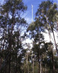
Tumbarumba Tower (click for full resolution):
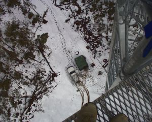
Tumbarumba Tower View Down (click for full resolution):
SOIL INSTRUMENTATION AND DESCRIPTION:
-
No information.
RADIOSONDE INSTRUMENTATION AND DESCRIPTION:
-
No information.
-
Web:
-
None provided.
Literature:
-
None provided.
- MDB (13 March 2007; Washington, DC, USA)