

Regional Hydroclimate Project:
-
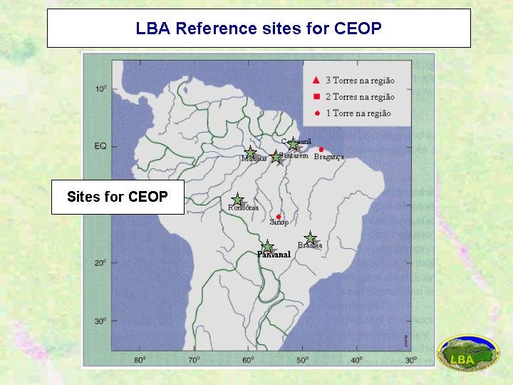
LBA (Large-Scale Biosphere - Atmosphere Experiment in Amazonia)
-
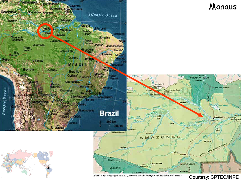
Manaus
-
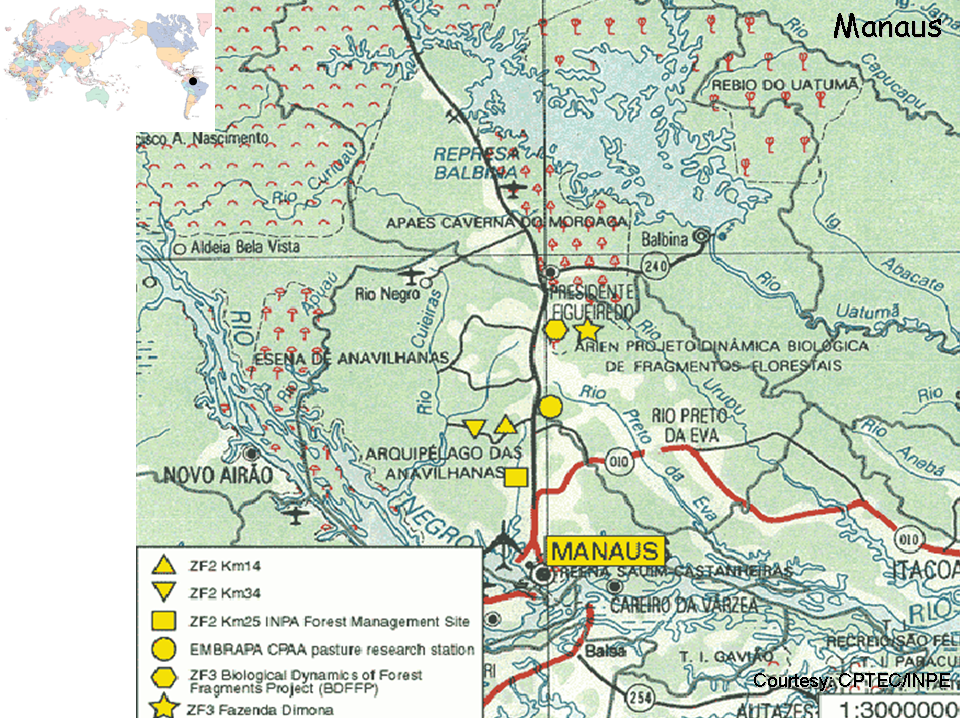
Km34
-
None.
-
Name:Antonio Ocimar Manzi
Affiliation:
-
LBA Implementation Manager / Central Office Coordinator
INPA
-
Av. André Araújo, 2936 - Alojamento nş 09 - Petrópolis
Cx. Postal 478
69011-970 Petrópolis
Manaus, Brazil
Telephone: +55(92)643-3255 / 236-5205
Fax: +55(92)643-3238/ 236-5131
-
Latitude: -2.61
Longitude: -60.21
Elevation: 130 m
LBA Regional Map (click for full resolution):
Regional and Area Maps (click for full resolution):
Station Description:
-
General Description:
No information.
Station Operator:
The LBA Manaus km 34 site is part of the LBA Project, managed by the Brazilian Institute for Amazon Research (INPA) which is subordinated to Brazilian Ministry of Science and Technology (MCT).
Vegetation and Land Use:
The capital city of the state of Amazonas is Manaus, located near the confluence of the Negro and Solimőes Rivers. This area of the central Amazon is relatively undisturbed compared to the eastern Amazon or the Andean Piedmont, but it is currently the focus of increasing deforestation pressure for pasture establishment and selective logging. The recent (1996) completion of the asphalt road (BR 174) linking Manaus with Boa Vista and Venezuela is already significantly increasing deforestation along the highway. The majority of the study sites in Amazonas are near Manaus. These sites are located within 100 km of the city in evergreen secondary and primary forest, pastures derived from primary forest conversion, logged forest, agrosilvo pastoral areas, and inundated areas. Many of these sites are located in preexisting research areas.
Dominant land cover at the measurement location: No information.
Canopy height: No information.
Density of Canopy: No information.
Land cover within 50 m of site: No information.
Land cover within 500 m of site: No information.
Land cover within 12 km of site: No information.
Seasonal land cover changes: No information.
Major changes in land cover at site from October 2002 to December 2004: No information.
Slope at the site: No information.
Other notes: None
Soil Type and Characterization:
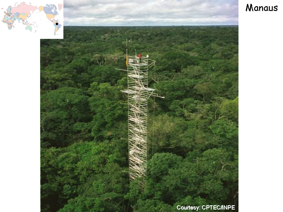
Soils are relatively nutrient-poor, sandy or yellow latosols (xanthic ferralsols). The forest in the area is typical terra firme forest (not subject to periodic flooding) with a canopy height of 30-37 m. Species richness of trees is high, averaging about 280 species per hectare. The understory is relatively open and dominated by palms. The site is located on pleistocenic terraces of interglacial origin and the topography is ondulated with mean altitudinal differences between plateaus and stream valleys of 40-50 m.
Surface soil type: No information.
Soil type in deeper layers: No information.
Surface soil porosity: No information.
Soil porosity in deeper layers: No information.
Soil infiltration rate: No information.
Bulk Dry Density: No information.
Saturated Hydraulic Conductivity: No information.
The Soil Reference Group(s) (from World Reference Base for Soil Resources): No information.
Climate:
The Manaus area has an annual precipitation that averages 2186 mm and a mean annual temperature of 27°C. The wettest months are March and April (c. 300 mm rainfall per month), and July, August, and September are the driest (<100 mm rainfall per month).
-
SURFACE METEOROLOGY AND RADIATION INSTRUMENTATION AND DESCRIPTION:
- Station pressure - measured; height and instrumentation not provided.
- Air Temperature - measured; height and instrumentation not provided.
- Dew point - measured; height and instrumentation not provided.
- Relative humidity - measured; height and instrumentation not provided.
- Specific humidity - measured; height and instrumentation not provided.
- Wind speed - measured; height and instrumentation not provided.
- Wind direction - measured; height and instrumentation not provided.
- U wind component - measured; height and instrumentation not provided.
- V wind component - measured; height and instrumentation not provided.
- Precipitation - measured; height and instrumentation not provided.
- Snow depth - Not measured.
- Incoming shortwave radiation - measured; height and instrumentation not provided.
- Outgoing shortwave radiation - measured; height and instrumentation not provided.
- Incoming longwave radiation - measured; height and instrumentation not provided.
- Outgoing longwave radiation - measured; height and instrumentation not provided.
- Net radiation measured; height and instrumentation not provided.
- Skin temperature - measured; height and instrumentation not provided.
- Incoming Photosynthetically Active Radiation (PAR) - measured; height and instrumentation not provided.
- Outgoing Photosynthetically Active Radiation (PAR) - measured; height and instrumentation not provided.
- Sensible heat flux - 53.1 m instrumentation not provided
- Latent Heat flux - 53.1 m instrumentation not provided
- CO2 Flux - 53.1 m instrumentation not provided
- Soil heat flux - Not measured.
METEOROLOGICAL TOWER INSTRUMENTATION AND DESCRIPTION:
-
No information.
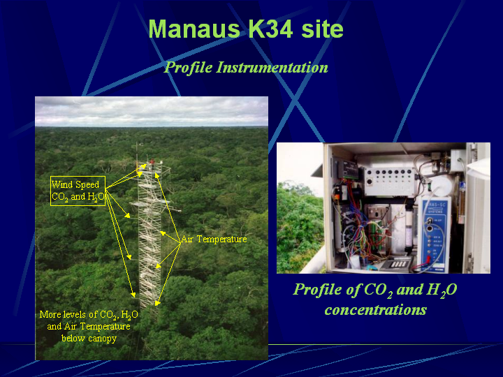
FLUX INSTRUMENTATION AND DESCRIPTION:
SOIL INSTRUMENTATION AND DESCRIPTION:
-
No information.
RADIOSONDE INSTRUMENTATION AND DESCRIPTION:
-
No information.
-
Web:
-
None provided.
Literature:
-
None provided.
- LBA (10 March 2004; Irvine, CA, USA)
- LBA (31 March 2003; Berlin, Germany)
- LBA (2 April 2003; Berlin, Germany)
- LBA (6 March 2002; Tokyo, Japan)
- EOP-3/4 and beyond Data Sets and Documentation
- Surface Meteorological Data: Current Status and Browse Plots
- Soil Temperature and Moisture Data: Current Status and Browse Plots
- Flux Data: Current Status and Browse Plots
- Meteorological Tower Data: Current Status and Browse Plots
- EOP-1 Converted Format Data Sets and Documentation
- EOP-1 Native Format Data Sets and Documentation