

Regional Hydroclimate Project:
-
CliC (Climate and Cryosphere)
-
BERMS
-
Old Jack Pine
-
Name:Alan Barr
Affiliation:
-
Atmospheric Environment Service
National Hydrology Research Centre
-
11 Innovation Boulevard
Saskatoon, SK, S7N 3H5
Telephone: 306-975-4324
Fax: 306-975-5793
-
Latitude : 53.91600N
Longitude : 104.69000W
Elevation : 579.27 m ASL
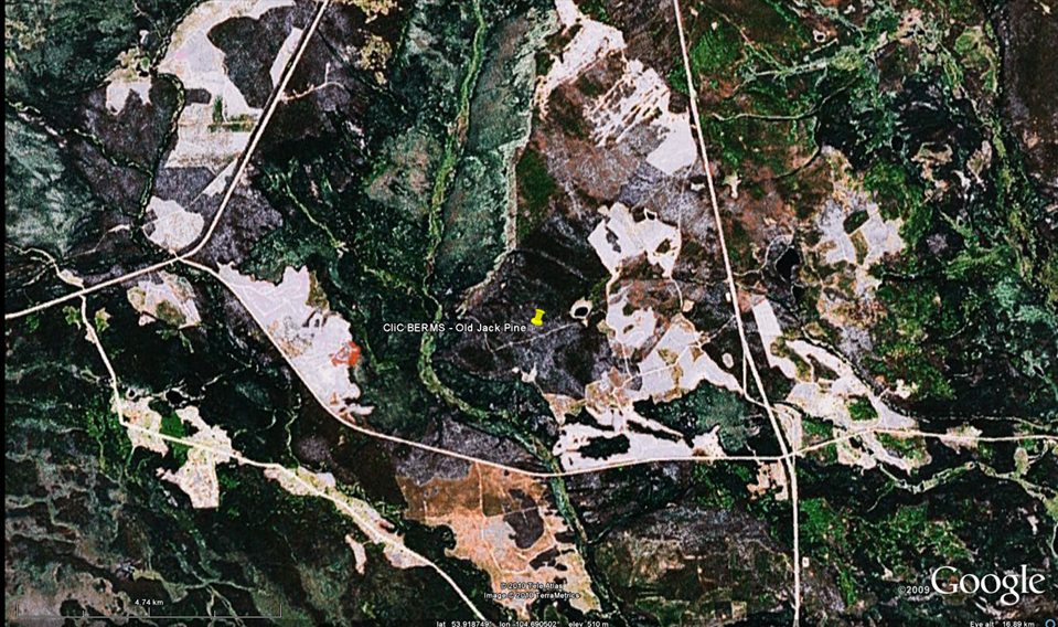
BERMS Old Jack Pine Local Station Map (click for full resolution):
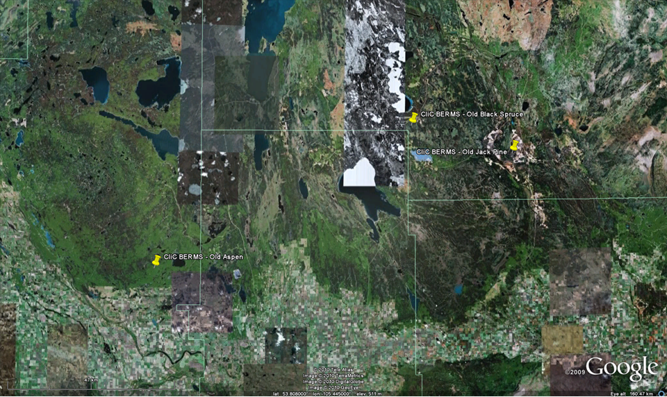
BERMS Regional Station Map (click for full resolution):
Google Earth:
Google Earth .kmz file of CliC BERMS Reference Site stations
Station Description:
-
General Description:
Near Narrow Hills Provincial Park (5km in from route 106, and 2.9km north of Harding Road and route 106 intersection).
Station Operator: No information.
Vegetation and Land Use:
Dominant land cover at the measurement location: No information.
Canopy height: No information.
Land cover within 50 m of site: No information.
Land cover within 500 m of site: No information.
Land cover within 12 km of site: No information.
Seasonal land cover changes: No information.
Major changes in land cover at site during CEOP data collection period: No information.
Slope at the site: No information.
Other notes: No information.
Soil Type and Characterization:
Surface soil type: No information.
Soil type in deeper layers: No information.
Surface soil porosity: No information.
Soil porosity in deeper layers: No information.
Soil infiltration rate: No information.
Bulk Dry Density: No information.
Saturated Hydraulic Conductivity: No information.
The Soil Reference Group(s) (from World Reference Base for Soil Resources): No information.
Climate:
-
SURFACE METEOROLOGY AND RADIATION INSTRUMENTATION AND DESCRIPTION:
- Station pressure 2m - Setra - in the Hut
- Air Temperature 27 m - Platinum Resistance Thermometer in a Met-One ventilator.
- Dew point - 27 m - derived
- Relative humidity 27 m - Vaisala HMP45C in a Met-One ventilator
- Specific humidity 27 m - derived
- Wind speed 29 m - RM Young Propeller Anemometer - mounted on a pipe extending above the top platform of the walk-up tower, 14m above the canopy at 29m agl.
- Wind direction 29 m - RM Young Propeller Anemometer - mounted on a pipe extending above the top platform of the walk-up tower, 14m above the canopy at 29m agl.
- U wind component 29 m - derived
- V wind component 29 m - derived
- Precipitation - Height unknown - Manually corrected Belfort 3000 precipitation
- Snow depth - Height unknown - Ultrasonic Depth Gauge SR50 - on a boom extending from a wooden stand in a 10m natural clearing 200m ESE of the Hut.
- Incoming shortwave radiation - 28 m - Kipp & Zonen CM11 - top of walk-up tower, mounted on railing facing southward 13m above the canopy at 28m agl
- Outgoing shortwave radiation - 23 m - Kipp & Zonen CM11 - on extended boom attached to walk-up tower facing south 8m above the canopy at 23m agl.
- Incoming longwave radiation - 28 m - derived from body and dome temperatures measured by the downwelling longwave sensor, as well as Global Shortwave
- Outgoing longwave radiation - 23 m - derived from body and dome temperatures measured by the upwelling longwave sensor , as well as upwelling shortwave
- Net radiation 23 m - derived - Note that these variables have been corrected prior to deriving four way net radiation.
- Skin temperature - Not Measured
- Incoming Photosynthetically Active Radiation (PAR) - 28 m - Li-Cor LI 190SB - top of walk-up tower, mounted on railing facing southward 13m above the canopy at 28m agl.
- Outgoing Photosynthetically Active Radiation (PAR) - 23 m - Li-Cor LI 190SB - on extended boom attached to walk-up tower facing southward 8m above the canopy at 23m agl
- Station pressure 2m - Setra
- Air Temperature 1, 5, 10, 16, 27 (stopped May 2003), 28 m - Vaisala HMP45C
- Dew point - 1, 5, 10, 16, 27 (stopped May 2003), 28 m - derived
- Relative humidity 1, 5, 10, 16, 27 (stopped May 2003), 28 m - Vaisala HMP45C
- Specific humidity 1, 5, 10, 16, 27 (stopped May 2003), 28 m - derived
- Wind speed 5, 29 m - RM Young Gill Cup Wheel Anemometer at 5 m and RM Young Propeller Anemometer at 29 m
- Wind direction 29 m - RM Young Propeller Anemometer
- U wind component 29 m - derived
- V wind component 29 m - derived
- CO2 Flux - 28 m - no instrumentation information
- Latent Heat Flux - 28 m - no instrumentation information
- Sensible Heat Flux - 28 m - no instrumentation information
- Soil Heat Flux - 0 m - no instrumentation information
- Soil temperature at NW Station 2, 5, 10, 20, 50, and 100 cm depths - Queen.s Univ-made soil temperature rod. - below the moss layer in a pit NW of the Hut.
- Soil temperature at SW Station 2, 5, 10, 20, 50, and 100 cm depths - Queen.s Univ-made soil temperature rod. - in a pit SW of Hut (down hill from Hut)
- Soil moisture Not measured at either location.
METEOROLOGICAL TOWER INSTRUMENTATION AND DESCRIPTION:
FLUX INSTRUMENTATION AND DESCRIPTION:
SOIL INSTRUMENTATION AND DESCRIPTION:
-
Two Sub-Stations: Old Jack Pine NW and Old Jack Pine SW. Provided locations (lat/lon/elev) are identical as above)
RADIOSONDE INSTRUMENTATION AND DESCRIPTION:
-
Soundings are provdied from the The Pas station in Manitoba (WMO ID 71867; 53.97N and 101.10W). Data are mandatory and signficant level. Data are typically available at
0000 and 1200 UTC daily.
OTHER INSTRUMENTATION AND DESCRIPTION:
-
No other measurements available.
-
Web:
-
None provided.
Literature:
-
None provided.
-
None known.