
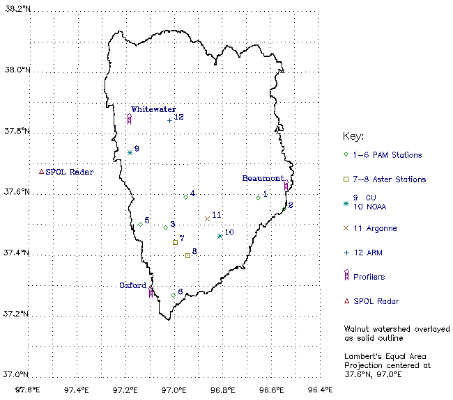
| Station Type |
No | Description | Location | ||||
|---|---|---|---|---|---|---|---|
| Legal | Geographic | ||||||
| Township | Range | Section | Lat (N) | Long (W) | |||
| PAM | 1 | pasture | 28S | 7E | S27 | 37.589 | 96.653 |
| 2 | high grass | 29S | 8E | SE 1/4 SE 1/4 S5 | 37.552 | 96.548 | |
| 3 | river valley (crops corn and soy) |
29S | 4E | S30 S31 |
37.491 | 97.035 | |
| 4 | low crop (in grass just north of tilled soybean field) |
28S | 4E | SW 1/4 SW 1/4 S24 NW 1/4 NW 1/4 S25 |
37.592 | 96.952 | |
| 5 | tilled milo field | 29S | 3E | NE 1/4 S30 | 37.503 | 97.140 | |
| 6 | winter wheat
(in flood plain) |
32S | 4E | NE 1/4 S17 NW 1/4 S16 |
37.269 | 97.003 | |
| ASTER | 7 | winter wheat | 30S | 4E | S16 | 37.444 | 96.997 |
| 8 | grassland (big bluestem) |
30S | 4E | NW 1/4 S36 | 37.401 | 96.945 | |
| CU | 9 | grass -- NS lake to S (N of road) |
27S | 2E | NW 1/4 S2 | 37.738 | 97.184 |
| NOAA | 10 | pasture with cows (little, big bluestem, gramma, brome, indian grass) |
30S | 6E | SE 1/4 S6 | 37.464 | 96.812 |
| Argonne | 11 | Smileyberg | 29S | 5E | SW 1/4 S14 | 37.521 | 96.864 |
| ARM | 12 | Towanda (alfalfa) |
37.842 | 97.020 | |||

![[NEW]](anim_gifs/5new.gif)