FIRE-3 CASE May 18 , 1998 |
David C. Rogers
Scientist |
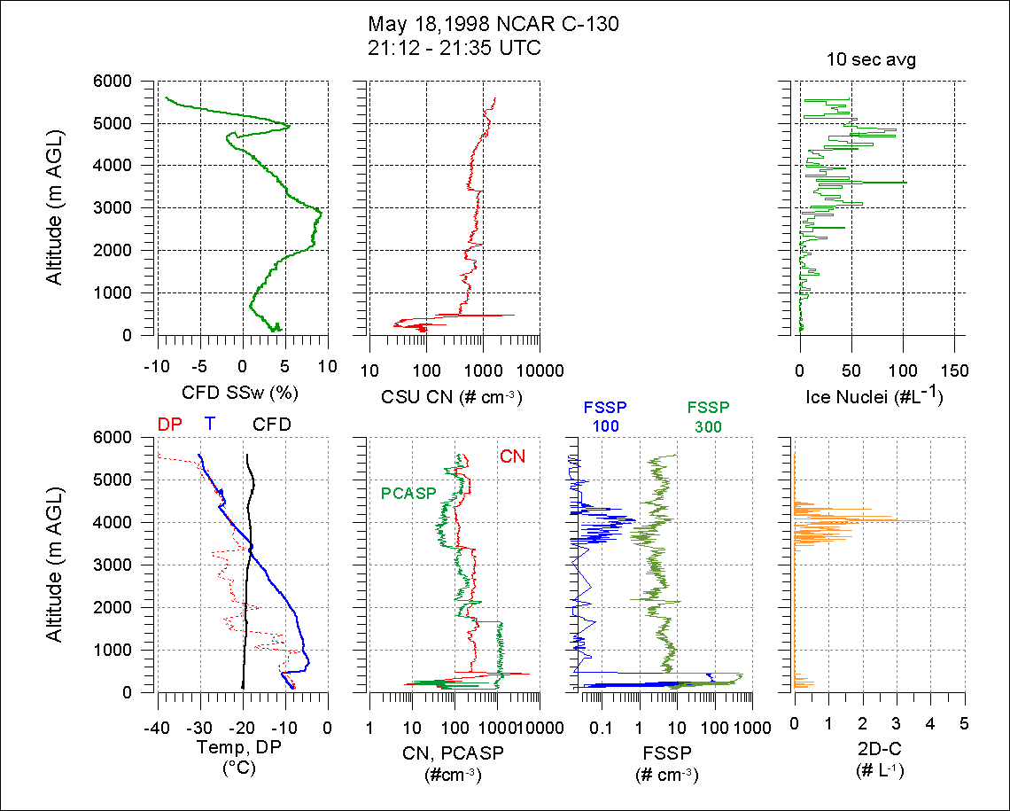
These notes describe some vertical features of the ice nuclei when the NCAR C-130 aircraft changed altitude near the SHEBA ice camp. In the first segment, 21:10 - 21:35, the C-130 descended from 5600m to 90m altitude over the ice pack within 40km of the SHEBA ship. During descent, the aircraft penetrated two cloud layers:
Data from NOAA's vertically pointing radar showed the upper cloud layer had been around all day and began dissipating ~22:00. The lower cloud had also been around but showed no signs of dissipating. Several temperature inversion layers were encountered during the descent. Inversions existed at 4.5 and 3.4km (base and top of As). The dominant inversion was 500-800m, capping the low level cloud.
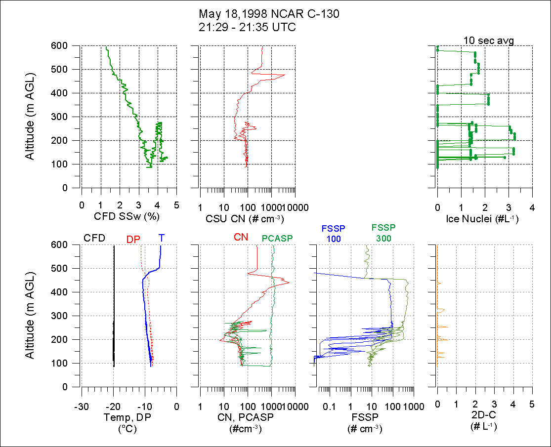
The second data segment shown here is two hours later when the aircraft climbed from inside the cloud to above cloud top and then descended into the surface layer.
While in the low level cloud, the C-130 anti-iced air sample inlet rimed shut due to the accumulation of super-cooled water. Within a few minutes, the ice melted off, and the sample flow was restored. As long as the aircraft remained in the supercooled water cloud, this cycle of riming shut and melting off continued. This inlet was the preferable one for ice nuclei sampling, but when problems with riming were recognized, an "interstitial" sample inlet was used. The interstitial inlet had other problems (not discussed here). Both inlets were used during the low level portions of the May 18 flight.
IN measurements were collected throughout the flight, inside and outside of clouds. When in cloud, droplets and crystals can enter the sample inlet; they may evaporate and become part of the sample, or they may get stuck on the walls of the piping and be excluded from the sample. IN data are obtained when in clouds, but is not obvious how to interpret such measurements. All IN concentrations shown here were averaged over 10 second intervals (approximately 0.17 liters).
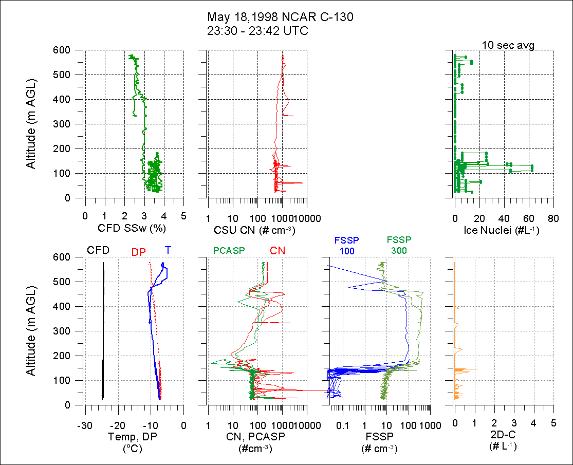
Deep soundings near the ice camp occurred during the arrival descent at 21:12 and the departure climb which began ~23:43. Figure 1 shows the arrival sounding 21:12-21:35 and Figure 2 shows the lowest 600m. During the arrival descent, ice nuclei were measured with the CFD at -19 to -20°C and a wide range of supersaturations, -9 to +9%. The intended standard procedure was to sample at nearly constant T and SSw during soundings, in order to isolate the vertical variation as the only variable. However, this procedure was not followed on the arrival descent. In this case, then, it is not clear whether the vertical variations of IN concentration are due to altitude (different strata) or to CFD operating conditions or some combination of both.
The temperature and CN soundings exhibited strong vertical stratifications, with boundaries between the strata at 5300m, 4400m, 3400m, 1700m and 500m. The strongest demarcation was at 500m, the top of the low level cloud. A dramatic thin maximum of CN occured in the top of the cloud. For the CSU CN data, this maximum may be an artifact (water splashing on the inlet creates droplets that evaporate to CN). However, the NCAR CN inlet faces aft and does not have this splashing characteristic. Thus, it seems likely that this maximum is not an artifact. Why should there be a local CN max near cloud top? Perhaps a photochemical gas to particle process could be responsible. This CN maximum was also observed, to a lesser degree, during the later vertical profile (23:30 Figure 3).
During the descent sounding, the general trend showed IN concentration
increasing with altitude. The smallest concentration occured in the surface
layer below the low level cloud. The following table shows IN data
averaged by vertical layers during the descent 21:12 - 21:35..
| Altitude (m MSL) | Average IN conc (#/L) | min IN - max IN conc (#/L) |
| 5600-4500m | 47 | 4-93 |
| 4500-3500m | 27 | 6-104 |
| 3500-1700m | 15 | 0-61 |
| 1500- 500m | 4.0 | 0-19 |
| 500- ~sfc | 1.1 | 0-3 |
Ice particle concentrations, estimated on the 2D-c probe shadow-OR signal, were up to 3/L in the As cloud and 0.5/L or less in the low level cloud. The vertical profile of CPI probe particle concentrations showed much higher values, ~50/L in both the As and low level clouds. A large fraction of the CPI images in the low level cloud were circular and <100µm.
Later IN sampling in the second segment (23:30 Figure 3) was done at -25°C, much colder than the environment (-5 to -11°C) and colder than the earlier IN measurements. The sampling supersaturation was fairly steady, +3%. From 23:30-23:43 the aircraft climbed above cloud top and then descended to the surface layer. The IN data showed the highest concentrations (up to 60/L) were just below cloud base at 130m. Low IN concentrations occurred elsewhere. The overall average during this time was 5.5/L.
In addition to the IN data Samples of IN particles were collected with the impactor at the outlet of the CFD. These are being analyzed by electron microscope for size and physico-chemical characteristics..