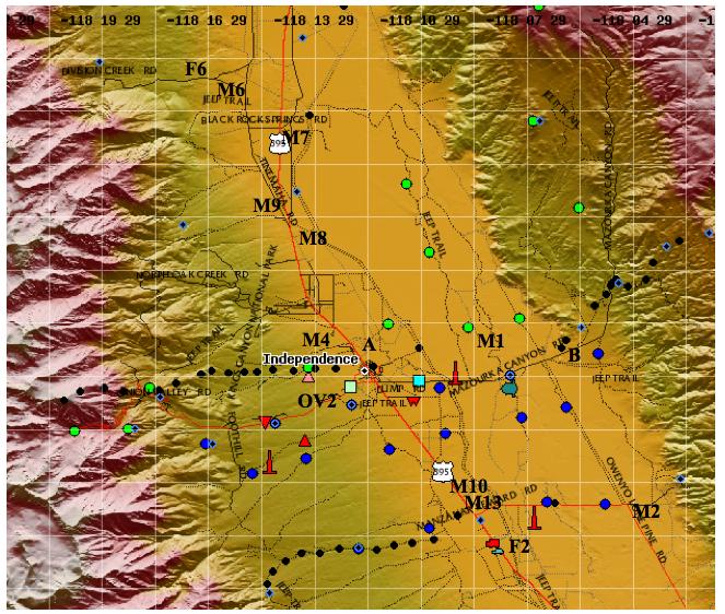
This is a list of potential sites for MISS (Mobile Integrated Sounding System) operations during the T-REX project. The order is approximately north-to-south (apart from the first site, which is the MISS base site). During non-IOP periods, MISS will generally be at the base site. If requested by the T-REX Science Director, it will be moved to one of the Roving Sites prior to the beginning of an IOP, and remain at that site until the IOP is complete. We will need to re-inspect each site prior to deployment to ensure the site is still suitable. Note that while at the roving sites, MISS operates off an auxiliary generator which may limit the hours of operation. The "Grade" column is just a wild guess of the expected data quality from each site (e.g., expected clutter and radio interference) and the access (and may be inaccurate!).
| ID | Description | Lat, Lon, Alt | Grade |
|---|---|---|---|
| F2 |
MISS Base Site This is the old MAPR site from the Sierra Rotors project. It is a road maintenacne pit approximately 1 mile SE of Manzanar. There is some shielding and is fairly private. It is also used for grazing mules. To access the site, drive south from Independence along 395 approx 6 miles (1/4 mile past Manzanar) and turn east onto a dirt road and drive in about 1/2 mile. |
36d 43.3m N 118d 8.5m W 1166m | A |
| Roving Sites | |||
| F6 |
Division Creek Road water table sampler There's a water sampling station about 3/4 mile up Division Creek Rd (which runs west off Tinemaha Rd about a mile north of Sawmill Creek Rd), just short of the Forest Service Boundary. MISS has to be carefully backed into the site. There is no shielding and the site can suffer significant clutter, however it is close to the mountains and MISS got good observations sitting under a rotor cloud here during IOP2. |
36d 56.397m N 118d 16.249m W 1259m | B |
| M6 |
Division Creek Pit This is an old gravel pit just southwest of the Division Creek Rd and Tinemaha Rd intersection (access off Division Creek), with a large turning area. When we visited a truck was being loaded with old scrap pipes, however the area is probably generally unused. A little shielding. A recent visit found the gate locked so we might not be able to use this site. |
36d 56.186m N 118d 15.783 W 1229m | B |
| M7 |
Black Rock Spring Rd Pit This road runs east from Hwy 395 about 9 miles north of Independence. About 1/4 mile along on the south side is an old pit, with an 8-foot berm and wide turning area. The berm will provide some shielding. |
36d 55.1m N 118d 14.25m W 1170m | A |
| M9S |
Old 395 North The old highway branchs west off the current highway about 5 miles north of Independence. This old road turns into Tinemaha Rd further north, however the southern end of the road appears to be unused. There is little shielding, however it may be a useful site because of the easy access. |
36d 53m N 118d 14.5mW 1190m | B |
| M8 |
Old Hwy 395 Pit This is about 2 miles north of Fort Independence Reservation, or about 5 miles north of the town of Independence. There are two possibilities here. The better site would be an old pit about 100 m down a gravel road that runs east from the old highway . This pit appears to have fairly good shielding. Another possibility is the old highway itself (probably backing into the T intersection), however there would be no shielding there. Access the area from Fort Independence Reservation, drive 2 miles north along Shabbell Lane through the unlocked gates. |
36d 51.993m N 118d 14.107m W 1202m | B+ |
| M4 |
North Independence Pit A gravel pit about one mile northwest of Independence Airport. There is only limited shielding for MISS and it may suffer from interference and clutter. Access the site by driving about 2.2 miles north of Independence on Hwy 395; turn southwest down a gravel road (almost directly opposite Fort Independence Road) and drive in SSW about 1/4 mile into the pit. |
36d 49m N 118d 13.1m W 1220m | B+ |
| A |
Independence Airport This is a little used airport and is the base site for ISFF. It was also the base for MISS during the Sierra Rotors Experiment. The sodar-RASS will be operating at this site, and will have to be shut-down if MISS is to operate here. It is about 1/4 mile N of town on the east side of highway 395. RASS quiet time should be set at this site. Some clutter. |
36d 48.6m N 118d 12.2m W 1196m | B |
| M1 |
Canoe Lake Sites North of Mazourka Canyon Road, about 3 miles east of Independence is a small lake and recreation area next to the Owens River. Around the lake are three or four sites that would suitable for MISS. For example on the southwest corner of the lake is a pullout that would have some shielding. There are also a couple of potentially useful pullouts about 1/2 to 1 mile north of the lake. These should be rechecked before using. To access, drive 3.1 miles east along Mazourka Canyon Rd from 395, turn north up a gravel road for 8/10 mile and look for the gravel road and lake on the right. |
36d 48.585m N 118d 8.649m W 1153m | A |
| B |
Kiersarge Mine site An old mine with wide parking lot. From 395 just south of Independence, take Mazourka Canyon road 5 miles east of Independence. Turn right (south) just behind the large hill with the old mine scaffold. This site was used during Sierra Rotors and has good shielding behind the hill. |
36d 48.5m N 118d 6.6m W 1178m | A |
| OV2 |
Onion Valley Two This site is 1.7 miles up Onion Valley road from 395 in Independence. The site is a J-shaped pullout on the north side. Backing in is required. The site may be useful as it is part-way between ISS2 and MAPR, however there may be interference with these systems and some ground clutter. |
36d 47.28m N 118d 13.32m W 1335m | B |
| M10 |
Shepherds Creek Site About one mile north of Manzanar is a gravel road on the east side of 395 - follow the road in about 1/2 mile and turn south to a low hill. Shepherd Creek runs on the south side of the side. The hill will provide some shielding, particularly if we back the trailer up into a small hollow, although there are some nearby trees. The area is sometimes used for camping. |
36d 44.932m N 118d 8.915m W 1167m | A |
| M13 |
Manzanar Airport There's an old airport at Manzanar, across the highway from the memorial with lots of flat area to turn and operate MISS. One option is the north end of the north-south runway. The access is good, however there's no shielding from clutter and lots of trees in the area. Access via Manzanar Reward Rd, which runs east from 395 and 1/2 mile runs directly across the runways, about 1/2 mile north of the memorial. | 36d 44.5m N 118d 8.8m W 1170m | B |
| M2 |
Corner Owenyo and Manzanar Reward Roads This site is 4 miles east of Manzanar, with a couple of short offshoot roads around the intersection that might be used to site and turn MISS. About 1/2 mile west of the intersection is DRI met station #15 with a dirt road triangle intersection that might also site/turn MISS. Both sites offer no shielding and should be rechecked before using. Access via Manzanar Reward Rd, which runs east from 395 across the old Manzanar Airport, about 1/2 mile north of Manzanar. Drive in 4 miles. |
36d 44.3m N 118d 4.7m W 1135m | B |