T-REX SITE SURVEY FOR ISS
Steve Cohn, Bill Brown, Lou Verstraete
August 22 – 25, 2005.
Report as of 9/9/2005, written by Bill Brown.
The TREX project requests the operation of three ISS in the Owens Valley, California, for March and April 2006. This project is an expansion of the Sierra Rotors project of March/April 2004 which used two ISS in a study of mountain waves and rotors. Refer to the Sierra Rotors site survey for more discussion of the general area and nearby towns. The ISFF groups site survey also has relevant information.
One of the ISS will use MAPR, another will be MISS, and the third is a standard ISS. Three so-called “fixed sites” are required as the MISS system requires a base site. 12 potential sites for the fixed sites were identified; three of these have been identified as preferred sites. 10 new sites for MISS temporary operations were found (in addition the sites identified during the Sierra Rotors project). Spectrum Analyzer tests found no RF interference at any of the sites.
MAPR
SITE (Dump Gravel Pit
Site, F4)
Lat: 36d 47.279m Lon: 118d 10.705m Alt: 1196m
This site is a lightly used gravel pit about a mile southeast of Independence. The floor of the pit is about 2 acres and is about 20 feet below the surrounding terrain thus shielding the profiler from clutter and interference. The area is owed by LA Water and Power and leased to the Inyo County Road Department. We have verbal agreement from representatives of both agencies (Paula Hubbard/LAWP and Ron Chegwidden?/Inyo) to use the site and with the pit supervisor (Paul Valden?), we identified an area within the pit we can use. There is a power line running to the nearby Independence Dump and ideally we would like to extend this line (about 250 yards) to the gravel pit to power the ISS. It is also possible to operate a generator, however that is undesirable because it is likely that the sodar will also be placed here.
To access the site, drive south from Independence along 395 approx ½ mile, turn east on the Independence Dump road (sealed), drive in about 1/3 mile and turn south over the Roading Dept mixing strip, down into the pit. The site is in the southeast corner of the pit.
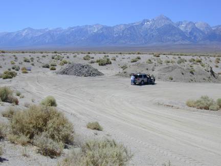
View looking down into pit at the area proposed to site MAPR. The view is towards the southwest. The container is proposed to locate this side of the asphalt pile and the profiler and sodar on the far side of the pile. The met. tower can be located out of the pit to the south. The ground on the south slope of the pit is being revegetated, however we can place equipment (met tower, even the profiler) on there provided we don’t disturb the land (stakes are okay).
The dump is to the east (left of photo) about 250m away. A power drop would most likely be placed close to where this photo was taken requiring a cable run of about 200 feet down to the trailer.
MISS
BASE SITE (Mule Site, F2)
Lat: 36d 43.3m Lon: 118d 8.5m Alt: 1166m
This site is the same site as we used for MAPR during Sierra Rotors and this year we plan to base MISS here while it’s not out roving around the valley. It is a dirt storage area about a mile southeast of the Manzanar historic monument. The site consists of two dirt/gravel hills (about 8 – 10 feet high) aligned approx east west, with a road/flat area and stream in between. The hills were found to provide good clutter shielding during Sierra Rotors, and is reasonably private from the road. The site is owned by LA Water and Power and is leased to a mule grazing operation. LAWP seemed to be happy with us using the site again. Like last year, a generator will be required, as will a fence around the site. The fence will need Taranaki gates for easy access by the MISS trailer.
To access the site, drive south from Independence along 395 approx 6 miles (1/4 mile past Manzanar) and turn east onto a dirt road. Drive in about ½ mile and turn right to the south side of the low hill.
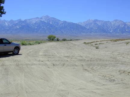
View of proposed MISS Base site looking west.
DBS SITE
(Onion Valley Site, F12)
Lat: 36d 46.676m Lon: 118d 14.911m Alt: 1505m
This site is up Onion Valley road approx 3½ miles west of Independence and about 4 miles west of the MAPR site. The site was site number OV4 of the MISS mobile sites during Sierra Rotors. It is also ¼ mile northwest of DRI station #2. It consists of a pull-out (actually part of the old Onion Valley road) on the north side of the road, with a short side road going north from that. The site is owned by BLM; we didn’t meet with them, however Vanda reports that they have been very receptive to her and other groups requests this year.
The trailer would be sited on the pull-out road, and the profiler would be sited 30m down the side road, which drops into a shallow gulley. This position would put the profiler about 10 feet below the surrounding terrain affording some shielding from clutter. There would still be a few trees visible to the profiler, however there were limited options in the area and it’s expected we will still get good data there. The site is hidden from the MAPR site by the adjacent ridges both here and at the MAPR gravel pit so there should be minimal interference between the two. A generator will be required at this site.
To access the site from Independence, turn west onto Market Street from 395 (Market turns into Onion Valley Road), drive up 3.4 miles and look for the pull-out on the right (north) side of the road. You’ll see DRI Met tower #3 on the left shortly before the pull-out.
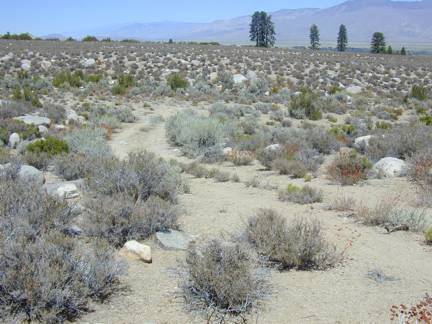
View looking NNE from about where trailer would be located, down side road where profiler would be located.
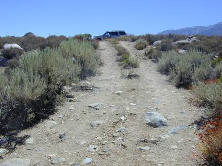
View back up side road from suggested profiler location towards trailer location (about where the SUV is). Looking south.
BACKUP
SITE (North Independence
Site, F5/M4)
Lat: 36d 49m Lon: 118d 13.1m Alt: 1220m
There is another little used gravel pit to about one mile northwest of Independence that would be suitable for a backup site for either MAPR or the DBS ISS. The gravel pit covers a couple of acres and includes a couple of depressions suitable for placing the profiler out of sight. These two depressions we’re calling A and B. For these A at the western end of the pit is easier access however there are signs of wet ground (recall that this last spring had exceptionally heavy snow) so we would need to be careful placing the profiler. Site B has better shielding in a hollow on the northern side of the pit (about 100m from A) however would require carrying the antenna around the end of the pit, wheeling it 75m, then carrying it 150m over rough ground. This site would require a generator. The site is apparently on BLM land (check this if we decide to use this site).
Access the site by driving about 2.2 miles north of Independence on Hwy 395; turn southwest down a gravel road (almost directly opposite Fort Independence Road) and drive in SSW about ¼ mile into the pit.
MISS ROVING SITES
During the Sierra Rotors project we identified 11 potential
sites from which to operate MISS while it’s roving away from its base. We should be able to use
most of these sites again. We
identified a number of new potential MISS roving sites. We will need to recheck many of these
sites just prior to ops to reassess access and suitability. These are roughly in north to south
order.
M9 Old 395, north of Independence (Tinemaha Road) . This long road runs parallel to (and about a mile west of) highway 395. It is sealed and has good access via Black Rock Spring Road (which changes name to Sawmill Creek Road to the west) – about 9 miles north of Independence and via Goodale Road (and Aberdeen) 4 miles further north. The southern 3 miles of this road is little used and MISS could probably be directly sited on the road. Some sections may have a little shielding. There are also some sites up side roads (eg, M5, M6, F6 below).
F6 Division Creek Road water table sampler. There’s a water sampling station about ¾ mile up Division Creek Rd (a gravel road that runs west off Tinemaha Rd about a mile north of Sawmill Creek Rd), just short of the Forrest Service Boundary. There’s a 20-25m turning circle and we need to recheck the access to this site. No shielding. Lat: 36d 56.397m Lon: 118d 16.249m Alt: 1259m.
M6/F7 Division Creek Pit. There’s an old gravel pit just southwest of the Division Creek Rd and Tinemaha Rd intersection (access off Division Creek), with a large turning area. When we visited a truck was being loaded with old scrap pipes, however the area is probably generally unused. A little shielding. Lat: 36d 56.186m Lon: 118d 15.783m Alt: 1229m.
M7/F9 Black Rock Spring Rd Pit. This road runs east from Hwy 395 about 9 miles north of Independence. About ¼ mile along on the south side is an old pit, with an 8-foot berm and wide turning area. The berm will provide some shielding. Lat: 36d 55.1m Lon: 118d 14.25m Alt: 1170m.
M5 Bee swarm corral. About ½ mile west up a gravel road (Forrest Service 12S04) from Tinemaha Road (old 395) about 1 ¼ mile south of Sawmill Creek Rd. There’s an old corral (which had a swarm of bees when we visited) with a small turning circle. We need to recheck access to this site. No shielding. Lat: 36d 53.895m Lon: 18d 15.707m Alt: 1216m
M8/F10 Old Hwy 395, about 2 miles north of Fort Independence Reservation, or about 5 miles north of the town of Independence. The old highway dead-ends just after a T (for a gravel road that runs east). We could use the T to back MISS into the dead-end. There will probably be clutter at this site. Also just to the east of this site there’s an old pit (with better shielding) that had beehives when we visited, however we may want to recheck it during the project. Access the area from Fort Independence Reservation, drive 2 miles north along Shabbell Lane through the unlocked gate. Lat: 36d 51.993m Lon: 118d 14.107m Alt: 1202m.
M3 Oak Creek Campground. This campground is about 4 miles northwest of Independence. There are a number of RV pullouts; many may be too tight for MISS however there is a turning circle at the western end where I may be possible to operate. We’ll need to recheck access and contact the campground operators. Some shielding from clutter, although many nearby trees. The road to the site is sealed, although a little narrow in places. Access by driving west 1 ½ mile up Fish Hatchery Rd (2 miles north of Independence), turn north onto North Oak Creek Rd, the campground is a mile up the road. (Note that ½ mile along North Oak Creek is a gravel road on the southwest side that loops back to N. Oak Creek and it may be possible to operate there). Lat:36d 50.523m Lon: 118d 15.966m Alt: 1503m.
M4/F5 North Independence Pit – a gravel pit although with only limited shielding for MISS. The backup for the fixed sites – see the comments above. Lat: 36d 49m Lon: 118d 13.1m Alt: 1220m.
F11 Treatment Plant. There is a wastewater treatment plant about ¾ mile east of Independence. This is a fenced (locked gate) area with four treatment pools. In general the berm is too low to provide much shielding for MISS, however it might be possible to place the trailer just east of the site so that the eastern berm (the highest at around 7-8 feet) might provide some shielding. Should recheck this site before using. Lat: 36d 48.6m Lat: 118d 11.2m Alt: 1170m.
M1 Canoe Lake Site. North of Mazourka Canyon Road, about 3 miles east of Independence is a small lake and recreation area next to the Owens River. Around the lake are three or four sites that would suitable for MISS. For example on the southwest corner of the lake is a pullout that would have some shielding. There are also a couple of potentially useful pullouts about ½ to 1 mile north of the lake. These should be rechecked before using. To access, drive 3.1 miles east along Mazourka Canyon Rd from 395, turn north up a gravel road for 8/10 mile and look for the gravel road and lake on the right. Lat: 36d 48.585m Lon: 118d 8.649m Alt: 1153m.
M10/F3 Shepherds Creek Site. About one mile north of Manzanar is a
gravel road on the east side of 395 – follow the road in about ½
mile and turn south to a low hill.
Shepherd Creek rounds on the south side of the side. The hill will provide some shielding,
particularly if we back the trailer up into a small hollow, although there are
some nearby trees. The area is
sometimes used for camping.
Lat: 36d 44.932m Lon: 118d 8.915m Alt: 1167m
M12 Farm next to Manzanar. The farm was a large turning area; when we visited there were large stacks of alfalfa hay bales, which may provide visual shielding, however not RF shielding. There will probably be clutter at this site. Access is via a gravel road about 2½ miles north of Manzanar or 3½ miles south of Independence, on the west side of 395. Drive onto the farm, heading south for about a mile. Lat: 36d 44.5m Lon: 118d 9.8m Alt: 1180m
M13 Manzanar Airport. There’s an old airport at Manzanar, across the highway from the memorial with lots of flat area to turn and operate MISS. One option is the north end of the north-south runway. The access is good, however there’s no shielding from clutter and lots of trees in the area. Access via Manzanar Reward Rd, which runs east from 395 and ½ mile runs directly across the runways, about ½ mile north of the memorial. Lat: 36d 44.5m Lon: 118d 8.8m Alt: 1170m.
M2 Corner Owenyo and Manzanar Reward Roads. This site is 4 miles east of Manzanar, with a couple of short offshoot roads around the intersection that might be used to site and turn MISS. About ½ mile west of the intersection is DRI met station #15 with a dirt road triangle intersection that might also site/turn MISS. Both sites offer no shielding and should be rechecked before using. Access via Manzanar Reward Rd, which runs east from 395 across the old Manzanar Airport, about ½ mile north of Manzanar. Drive in 4 miles. Lat: 36d 44.3m Lon: 118d 4.7m Alt: 1135m.
M1/F1 Bairs Creek, about ¼ - ½ mile southwest of Manzanar. There are a couple of sites here that may be suitable for MISS roving, although the drive in is rather long and fords a creek. Access is either through Manzanar (although there are some low trees that may make this difficult) or take the gravel road that runs along the north side of Manzanar (Forrest Service 14S01), it turns south after ¾ mile, follow it for about another mile (Forrest Service 14S04). There’s a side road off to the west that could work for a site (although with no shielding). Alternatively there’s a low dirt hill with large turning area about ¼ mile further along (which may provide a little shielding). Lat: 36d 42.73m Lon:118d 9.69m Alt: 1224m.
TOWNS / FACILITIES / ETC
We know the nearby towns and facilities from the Sierra Rotors project and they are discussed in that projects site survey as well as in the ISFF survey. The nearest nearby large town is Bishop. Two hotels that seem promising are the Holiday Inn Express (where we stayed for Sierra Rotors) and the Vagabond Inn; both have high-speed internet access, rooms with fridge/microwave, and reasonable rates. During operations some might consider staying in Lone Pine (about 15 miles south of Independence) where the Comfort Inn also offers these facilities. The Lone Pine Best Western Frontier Motel has internet and fridges in the rooms. All hotels can be heavily booked, esp. as the fishing season starts in April, so early reservations will be needed.