 SCMS Project ISS Data Quality Review
SCMS Project ISS Data Quality Review
SCMS Project ISS Data Quality ReviewThe data recovery obtained from the ISS site in SCMS was reasonably good. The overall data quality was very good. A few problems were encountered and are addressed specifically herein. Note that this document addresses data obtained from the SCMS ISS deployment only. Information on data obtained from other platforms is not addressed in this report.
Operations were interrupted on a few occasions. The first interruption occurred on July 27 when there were problems with power generation. Surface data ingest was lost at approximately 1330Z and the entire ISS was shut down at 1730Z on the 27th. A few days later, hurricane Erin forced an interruption in operations for just over a day. The site was shut down and evacuated due to the storm at 1742Z, August 1st. The ISS resumed operation at 1130Z on August 3rd.
After July 27th, it was decided to shut down the ISS overnight. This was done primarily because of the difficulty associated with getting fuel to the site after the access "road" had become increasingly soggy from repeated rains. The ISS was only operated during daytime hours from July 27th through August 4th and again from August 7th through August 10th. The ISS was operated around the clock from August 4th through August 6th and from August 10th through August 14th, the end of the project.
There is one major gap in the surface data record from the project. That gap runs from roughly 1330Z on July 27th until late in the day July 31st. This gap was caused by a failure in the surface data ingestion software in the ISS Sun computer system. The software failure was believed to be associated with the power generation problems encountered on July 27th. (A fix was not implemented until after the weekend.) Surface data was again recorded successfully for a short period on the 31st of July.
Any subsequent surface data gaps were associated with ISS shutdowns as detailed in the previous section. There were several overnight shutdowns and one longer shutdown due to hurricane Erin.
During the hurricane, the wind sensor (prop-vane anemometer) was blown off its mount. This was repaired and back in operation on August 3rd at 1330Z. The wind direction and wind speed data are thus invalid from the end of operation on August 1st until this time. On August 4th, a prop blade was noticed missing from the wind sensor. This had come off (apparently damaged but not broken at the time the sensor mounting was fixed after the hurricane) sometime after 1330Z on August 3rd. The wind sensor was replaced on August 6th at 1430Z. The wind speed data are invalid from the time the prop broke off until August 6th at 1430Z.
One significant problem encountered at the SCMS ISS site was that of radiational heating of the ISS surface temperature sensor. This problem became apparent in evaluating sounding temperature profiles. The surface temperature was too high when compared with the temperature from a ventilated, shaded sonde just prior to launch. This showed up dramatically in the resultant quick-look skew-T plots. (Note that when this heating occurred in the surface sensor, the ISS surface temperature data have been replaced in the final sounding data set as detailed later in this chapter).
The radiational heating of the ISS surface temperature sensor was confirmed through direct comparison with a PAM III temperature sensor located at the same height about 100 meters farther down the site access road. In one case, the ISS surface temperature sensor read 1.5 to 2.0 degrees Celsius greater than that of the PAM III sensor during the day then came back to within 0.5 degrees Celsius of that sensor throughout the night.
As one of the PAM III sites in SCMS was located less than 100 meters down the ISS access road, data from that platform may be useful when working with the ISS data. Certainly, the PAM III data may serve to fill some of the data gaps in the ISS surface data record.
Profiler and RASS Data
Consensus wind data from the profiler were compared to wind data obtained from the balloon soundings. The profiler wind data consensus nearest the balloon launch time was used in that comparison. Note that this comparison compares instantaneous wind data (actually smoothed over one minute) with wind data averaged over time (25 minutes) and space. Plots of these comparisons for each sounding are included in Appendix C. Daily plots (time-height) of profiler consensus winds are presented in Appendix G.
Consensus virtual temperature data from the RASS operation were also compared to the balloon sounding data. Again the RASS data nearest the sounding launch time were used for the comparison. The balloon sounding virtual temperature data were computed from the sounding temperature, relative humidity, and pressure. Plots of the data are presented in Appendix H. The plots show agreement to within one degree or less, sustained over several hundreds of meters in many instances. The plots do show a slight "cold" bias in the RASS sounding values (the balloon sounding values are generally slightly higher than those from the RASS consensus data). In addition, there are times, particularly near the surface, where the two virtual temperature values diverge by up to two degrees or more.
As project data processing and evaluation progressed, consensus virtual potential temperatures were calculated from the existing RASS files and available surface data files. This effort resulted in a separate set of netcdf RASS data files containing one additional variable, "v_theta". Note that the times for which virtual potential temperatures could be calculated were limited by available surface data. Refer to the section on surface data quality to determine where there are gaps.
The virtual potential temperature values were obtained using surface data (pressure and calculated virtual temperature) and the RASS heights and virtual temperatures with the hypsometric formula. The hypsometric formula relates height change to pressure change using a layer mean virtual temperature. It is given as follows.
Here:
Virtual potential temperature profiles are plotted and included in Appendix H. It may be of interest to try to correlate the convective boundary height with the virtual potential temperature profiles. In addition, plots comparing virtual potential temperatures calculated from the CLASS soundings to those from the RASS are also included in Appendix H. The virtual potential temperature values from the CLASS soundings show a more defined mixed layer (constant virtual potential temperature with height) than do the corresponding RASS values. These comparisons reflects the virtual temperature "cold bias" referred to above.
Profiler data were processed to provide 25 minute consensus wind data files. These files contain consensus horizontal wind and signal-to-noise data for each range gate (altitude above ground). There are three columns of signal-to-noise ratio data in these consensus files: snr1, snr2, and snrw. Snr1 and snr2 are data from the first two orthogonal oblique beams in the beam sequence. Snrw has data from the first vertical beam in the beam sequence. The files are provided in both ASCII and netcdf format. The ASCII files are named using time (hhmm) and julien day. The netcdf files are named using time (hhmmss) and year, month, and day.
The profiler wind data consensus files were generated from data obtained between five and thirty minutes past the hour and between thirty-five minutes past the hour and the next hour. In clear air operation, the consensus winds required that 55% of the data be within a 2 m/s window. Vertical motion subtract was enabled.
Radio acoustic sounding system (RASS) virtual temperature data were processed to provide five minute consensus files. These files contain consensus virtual temperature data for each range gate (altitude above ground). They are provided in both ASCII and netcdf format. The naming conventions are the same as those for the profiler wind data files.
The RASS consensus virtual temperature data files were generated from data obtained between the hour and five minutes past the hour and between thirty minutes and thirty-five minutes past the hour. The consensus data required that 65% of the data be within a 6m/s window. Again, clear air vertical motion subtract was enabled. The RASS vertical temperature profile was obtained using the vertical beam specified in Appendix B using radar parameter set #4.
Note that in all projects, raw spectral data are saved. This will allow for the possibility of re-processing. At present it would thus be possible to re-run the profiler operating program (POP) with different consensus parameters after the project was completed. In addition, various alternative profiler processing techniques are currently being developed and evaluated.
The profiler/RASS radar parameter sets, including beam information, are given in Appendix B. The information provided gives the radar parameters for each beam, the number of beams used, individual beam orientation, and the beam sequence used. This information was valid for the entire project, with one minor exception.
For two short periods, the profiler was run using the vertical beam only to try to determine rain rates with the profiler. This was done with the permission of the investigators. On August 1st, the profiler operation was switched to this vertical mode from 1520Z until 1540Z and from 1730Z until 1742Z (shutdown for hurricane Erin).
The profiler operating system can store four different sets of radar parameters. Any one beam can be set up to utilize one of these parameter sets (see table 1A in Appendix B). In the presentation in appendix B, if a parameter set is not used that set is left blank. Note that radar parameter set #4 is always the parameter set used for RASS operation. The vertical beam used for the RASS consensus is indicated by an "R" in table 1B in Appendix B.
Appendix B summarizes the radar operating modes for the ISS during SCMS. Part A of the table describes four sets of radar system parameters - information on the timing signals and the sampling intervals resulting from those signals. Part B shows the sequence of beam directions and the parameter set chosen for each beam. The radar operating mode is specified by the information in this table as data is collected for each beam in the order and with the parameters chosen. The vector wind is found by combining information from several beam directions.
The first 6 rows of part A show derived intervals and values based on other system parameters. SCALE is the Nyquist interval, or maximum positive and negative radial velocity observable (along the beam) with the sampling rates chosen; DWELL is the time spent collecting samples before moving to the next beam; RANGE shows the lowest and highest along-beam range (above the antenna, not above sea level) for which observations will be made; IPP is the inter-pulse period or time between transmitted pulses expressed in km, which constrains the highest altitude to which data may be sampled; and PULSE is the transmitted pulse length in m, which sets the finest range resolution possible.
The next three rows of this table are values chosen by the operator, rather than derived values. IPP again is the inter-pulse period, but now in us. Changing the IPP will affect all the derived parameters in the first 6 rows with the exception of PULSE. PW is again the pulse width, now expressed in ns. The wind profiler is designed with four possible PW values 400, 700, 1700, and 3300 corresponding to spatial pulses of 60, 105, 255 and 462m. CODE BITS allows for increased sensitivity but its use is limited by the maximum transmitter duty cycle. Possible values are 0, 1, 2, and 4.
The final 6 rows of part A describe more parameters chosen by the operator. NHTS is the number of ranges sampled. DELAY in ns affects the waiting time before the first range sample - it specifies the lowest measured altitude. SPACE in ns is the distance between ranges sampled. SPACE is limited to the same four values as PW, and typically it is chosen to be the same as PW, but over-sampling or under-sampling is possible.
The COH AVG value is the number of coherent averages of raw radar return data used to generate one point (each of NPTS) to be used in a Fourier transform that will generate one spectral average. Coherent averaging can increase the profiler sensitivity, and also will affect the SCALE and DWELL. NPTS is the number of spectral points used in the Fourier transform to produce one spectral average. It affects the velocity resolution of the Doppler spectra and will affect DWELL. Finally, the SPEC AVG value is the number of spectral averages taken during the beam DWELL period. This affects signal detection, and obviously the DWELL.
If one multiplies the COH AVG value, times NPTS, times the SPEC AVG value, the number of radar pulses within a given DWELL time is obtained. That DWELL time being the summation of the pulse times and any delays in the operation of the system.
Part B of the table shows the sequence of beam directions and parameter sets used. The profiler has 5 beam directions - four oblique beams at 90 degree intervals in azimuth with an elevation angle of 67 degrees, and a vertical beam (with two possible polarizations). Each row in part B shows the beam number, the parameter set used (as defined in part A), and the elevation angle of that beam. The profiler sequences through each row and then returns to the top in a continuous cycle.
In Appendix F, the signal-to-noise ratio data have been plotted in time - height contour plots. These data are actually range corrected to improve the presentation. The range corrected data are in decibels. (The signal-to-noise ratio data, in dB, in the consensus data files are not range corrected.) In the range correction used, the signal-to-noise ratio value at each range gate is multiplied by the range squared. (Note that in dB, this is equivalent to adding 20*log10(range) to the signal-to-noise ratio in dB.) The presentation uses the vertical beam signal-to-noise ratio data only, thus range along the beam is equivalent to altitude.
In several plots presented in Appendix F, maxima in range corrected signal-to-noise ratio data can be seen, particularly through the period from 1200Z to 1700Z. During that period these maxima increase in height with time as the convective boundary layer grows through the day. These maximum contours effectively trace the growth of the convective boundary layer (they approximate the height of the top of the convective boundary layer at any given time).
The plot of data from August 11th shows this growth of the convective boundary layer top. One can easily see that convective boundary layer growth from 1300Z through 1700Z. If the maxima in range corrected vertical beam signal-to-noise data are compared to the balloon sounding data from this day, remarkable agreement is seen: the convective boundary layer height as discerned from the balloon sounding agrees extremely well with the maximum in range corrected signal-to-noise ratio.
Note that profiler vertical beam signal-to-noise ratio data are presented for all days of ISS operation in Appendix F. It is noted that in a number of days, there is no clear maximum in signal-to-noise ratio data tracing the convective boundary layer. This may be due to a number of things, most likely clouds or rain.
Most of the soundings made had good data recovery. There was very little lost data and only occasional periods of bad data. The periods of bad data were usually of short duration.
The periods when there are bad radiosonde Loran-C winds are easily identified in the comparison plots of Appendix C. Here wind data from the profiler are plotted with the radiosonde wind data. Overall, these plots show reasonably good agreement between the two wind measurements. Remember that the radiosonde wind data are more or less instantaneous and that the profiler wind data are an average over 25 minutes. In addition, the time overlap for the comparison is not always exact. It takes a little less than 15 minutes for the balloon to ascend through the depth of air that the profiler "sees". The sounding launch time and the consensus file mid-point time are given on each of the plots.
Note that when these bad Loran-C winds occur, they are associated with acceptable "Q" values (see section Individual Sounding Data Quality). This is a function of the fact that the "Q" value is nothing more than the standard deviation of the wind data over the smoothing interval used for the wind data calculation. (See "SSSF Observing Facilities: Description and Specifications".) It is possible for the navigator to generate bad data over a sufficient period to produce bad winds with an acceptable standard deviation. The investigator should be aware of this situation and use the "Q" values with caution.
The thermodynamic sensors performed reliably throughout the project. There was virtually no lost data due to a pressure sensor failure. The temperature and humidity sensor performance was good as well, with the exception of some sonde sensor arm heating at launch in some soundings.
Data recovery or availability is represented graphically in Appendix D. This presentation is derived from the "Ten-Second Data" file. Sounding data losses can be associated with problems in various system components. In the case of no data, or intermittent data, it is likely due to a failure of some type in the sonde, commonly a transmitter problem or an antenna problem. In the case of missing or bad wind data the problem is most likely associated with the Loran-C reception by the sonde or relay of that signal to the ground station.
In soundings where the surface temperature from the ISS was determined to be too high (due to radiational heating) another temperature, either the PAM III temperature, if available, or the temperature from the sonde before launch was substituted as the surface temperature in the sounding post processing. In use of a sonde temperature, care must be taken to make sure that the sonde temperature was reasonable - i.e. a temperature taken from a shaded, well ventilated sonde having no hint of sensor arm heating (see following discussion). In all, twenty-two soundings were reprocessed using a replacement surface temperature. Those soundings are listed on the cover page of Appendix E.
Another problem addressed in post processing was that of sonde sensor arm heating. There were times when this problem clearly affected the sonde PTU data before and just after launch. The sondes in SCMS were launched outside the trailer using a bag launcher. In the hot, sunny conditions, sonde sensor arm heating could easily occur if the sonde were not adequately shaded. In sonde sensor arm heating, the sensor arm itself heats up resulting in too high a temperature reading and too low a relative humidity reading.
The humidity reading is low due to the way in which the sensor works. The humicap sensor gives a reading of humidity relative to the temperature of the sensor arm itself. If the sensor arm is warmer than the environment, that humidity reading will be lower than ambient as the ambient vapor pressure remains unchanged, but the saturation vapor pressure (based on the temperature of the sensor arm) is higher than ambient.
At launch, the sonde is ventilated by the rising balloon. The temperature sensor is mounted in a very thin cylinder at the end of the radiosonde sensor arm. The thermal time constant of this cylinder is such that the temperature data recovers completely within the first ten seconds of ascent. The humidity sensor is mounted on a flat plate which has a slower thermal time constant. (The thermal time constant of the flat plate was determined to be nearly 14 seconds at 3.0 m/s ventilation in wind tunnel tests. NOTE: this is NOT the relative humidity sensor time constant.) Thus, it takes from up to 60 seconds for the humidity sensor to come to equilibrium with the environment.
A correction has been developed for the sensor arm heating. That correction uses the surface data and determined thermal characteristics of the sensor arm to correct the data over the first portion of the sounding. The correction was applied to many of the ISS soundings in SCMS. The first line of the file header indicates whether or not the correction was applied. The details of the correction can be obtained in the following reference:
Cole, H. L., and E. R. Miller, 1995: A Correction for Low-Level Radiosonde Temperature and Relative Humidity Measurements. Proc., Ninth Symp. on Meteorological Observations and Instrumentation, Charlotte, Amer. Meteor. Soc., 32-36.
As part of the overall SCMS effort, which also included deployment of three PAM III sites and the use of the CP2 radar, "Mobile CLASS" soundings were taken during the first part of July. Although not part of the ISS data set, those soundings are included and addressed herein. Comments as to the quality of the data from these soundings are included in the next section. Note that where appropriate, the "Mobile CLASS" surface temperature was replaced with a sonde temperature in reprocessing.
Note that in the stability parameters calculated for the mobile CLASS soundings, the value for CAPE will not always be completely accurate. It will be somewhat less than the actual CAPE value as most of these soundings truncate below the level that would complete the CAPE area determination in the sounding analysis. In such cases, the CAPE area calculation ends at the termination of the sounding.
The "COMMENTS ON DATA QUALITY:" are included to address and explain problems encountered in the sounding data. Although, effort is extended to cover as many data problems as possible, it is certain that not every bit of spurious data will be addressed herein. It is hoped that the comments provided will give the investigator using this data a good understanding of the possible problems that are sometimes encountered and an overall feel for the system and sensor performance.
Note that general comments about the data, not necessarily regarding problems, are also included with these comments.
In addition, the operator comments are included in the following section.
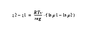
� 1 refers to the surface value.
� 2 refers to the height for which a pressure value is calculated.
� z is height.
� p is pressure.
� Tv is the layer mean virtual temperature.Consensus Parameters, Radar Parameters, and Beam Information.
Vertical Beam Signal-To-Noise: The Convective Boundary Layer
Radiosonde Data
CLASS Sounding Post Processing
Mobile CLASS Soundings
Stability Parameters
Individual Sounding Data Quality
Site: ISS4 -- Lake Loughman - Snake Creek Bridge Road, Florida
Email: cole@ucar.edu
Last Modified August 1 1996 at 15:29MDT