Operations
Field site
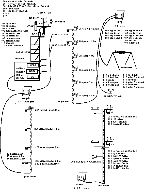
The CACHE94 operation offered several special problems not encountered in the conventional ``flat land'' deployments. The access to the mountain top was a steep, poor-surfaced road and the conventional towing vehicles could not deliver the ASTER trailers to the site. Local logging contractors, using heavy equipment, were employed to haul the trailers to the site. Due to the limited area available on the ridge top and the presence of the existing instrumented towers and seatainers serving as research shelters, the ASTER towers and sensors had to be deployed among the existing structures. The bare rock surface precluded the use of driven stakes for guy attachments and a limited number of one ton concrete ``dumplings'' served as tower bases and guy points. This resulted in difficulty in the establishment of the desired directionality to the sensor booms. The tower bases were fixed atop the concrete dumplings at different elevations and this displacement had to be taken into account when specifying sensor heights. An advantage of the site derived from the forested nature of the slopes. As the displacement height was some 5 meters or so the ASTER trailers could be positioned within fifteen meters of the towers without inducing flow disturbance. This allowed for a simpler power and data cable layout.
Click here to see the equipment layout for CACHE94
The location of the radiation sensors presented a problem. All the flat areas at the site had bare rock or disturbed gravel surfaces and the more representative forested areas had fairly extreme slopes and were difficult to access. A trail was cut into the vegetation down the southern slope of the ridge and the radiation stand was erected with the cross beam accurately level with an east-west orientation.
The environment at Cheeka Peak often presented conditions of wind-driven cloud. This situation imposed a severe test on the entire sensor network. The sensors themselves, the electronics and the cabling connections all were susceptible to water invasion. Equipment and procedures had to be adapted to overcome this problem.
Figure 6 depicts a schematic of the equipment layout at the CACHE94 site.
Operational periods
The ASTER system was fully operational by 8 August and, for the duration of the field program, data was continuously acquired from all the ASTER-maintained sensors.
Operational period 8 August - 24 September 1994; julian days 214 - 268
- First operational period, ops1 : jd(1994, 214, 00:00:00 - 1994, 218, 21:00:00)
- Second operational period, ops2 : jd(1994, 218, 21:00:00 - 1994, 221, 18:48:00)
- Third operational period, ops3 : jd(1994, 221, 18:48:00 - 1994, 224, 15:41:00)
- Fourth operational period, ops4 : jd(1994, 224, 15:41:00 - 1994, 227, 20:46:00)
- Fifth operational period, ops5 : jd(1994, 227, 20:46:00 - 1994, 228, 01:31:00)
- Sixth operational period, ops6 : jd(1994, 228, 01:31:00 - 1994, 231, 17:00:00)
- Seventh operational period, ops7 : jd(1994, 231, 17:00:00 - 1994, 235, 19:00:00)
- Eight operational period, ops8 : jd(1994, 235, 19:00:00 - 1994, 256, 18:20:00)
- Ninth operational period, ops9 : jd(1994, 256, 18:20:00 - 1994, 260, 16:30:00)
- Tenth operational period, ops10 : jd(1994, 260, 16:30:00 - 1994, 268, 00:00:00)
Tear-down commenced 24 September 1994.
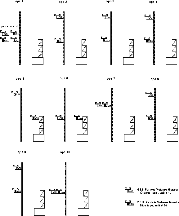
Figure 7 Schematic illustrating differing placements for the two PVM's
The original archiving configuration of the sensors which was established for the first operating period of CACHE94 is shown below.
The fast sensors on the walkup tower were originally archived as marigold 100, 101, 200, 201, and 202.
Walkup tower fast sensors
marigold 100,101,200,201,202 walk/fast
The slow sensors on the walkup tower and in the seatainer were originally archived as marigold 102, 103, 104, 105, 106, 107, 108, 109, 110, and 111.
Walkup tower & seatainer slow sensors
marigold 102,103,104,105,106,107,108,109,110,111 walk/slow
The psychrometers and the barometer were originally archived as marigold 204, 205, 206, 207, 208, 209, 210, 112 ,113, and 114.
Psycs and barometer
marigold 204,205,206,207,208,209,210,112,113,114 psyc/psyc
The propellor vanes were originally archived as daisy 202, 203, 204, 205, 206, and 207.
Props
daisy 202,203,204,205,206,207 prop/prop
The sensors on the flux tower were originally archived as cosmos 100, 101, 102, 103, 104, 105, 106, 107, 108, 109, 200, and 201.
Flux tower
cosmos 100,101,102,103,104,105,106,107,108,109,200,201 flux/fast
The radiation sensors, the soil sensors and the rain sensor were originally archived as daisy 100, 101, 102, 103, 104, 105, 106, 107, 108, 109, 110, 111, 112, 113, 114, 116, 117, 118, 119, 120, 121, 122, and 123
Rad farm, tsoils, rain
daisy    100,101,102,103,104,105,106,107,108,109,110,111,
         112,113,114,116,117,118,119,120,121,122,123      rad/rad
Changes in this archiving configuration lead to the establishment of a subsequent operational period.
The nominal original sensor configuration was as shown in Figure 6. Subsequent operational periods were occasioned either by changes in the archiving configuration or by changes in the positions of the two Particle Volume Meters (PVM's). A schematic of the different configurations for the two PVM's is shown in Figure 7.
Cloud research periods
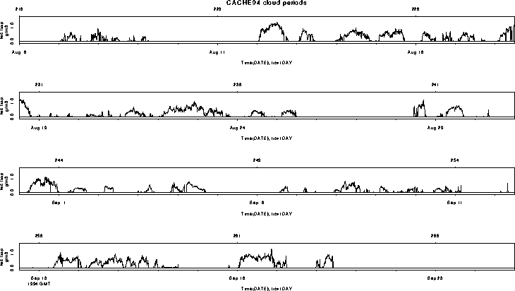
The prime objective of CACHE94 was the investigation of the turbulent deposition of cloud droplets. Cloud periods were frequent, lengthy, and thick during the campaign, as can be seen in Figure 8. Results from CACHE-1 indicate that periods of steady and continuous cloud are suitable for the measurement of cloud water deposition. This criterion is quantified as the mean-scaled standard deviation of cloud liquid water content; during CACHE-1, a value of 0.3 has been found (for half-hour statistics) to be a reasonable threshold for a 10m sensor height, stratifying cloud events into steady and more variable types.
The preferred wind direction for examination of turbulent fluxes (of liquid water, CO2, heat, momentum, etc.) is from the South-Southwest to North-Northwest. These conditions prevailed during cloud events, but clear-air periods must be segregated by wind direction in order to minimize the effects of flow distortion by the towers, booms, and instruments.
Figure 8 Cloud periods during CACHE94
Last Modified: 12:05pm MDT, July 4, 1996